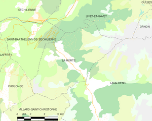
canton of Valbonnais (canton de Valbonnais)
 Hiking in canton of Valbonnais
Canton de Valbonnais, located in the Isère department of the Auvergne-Rhône-Alpes region in southeastern France, is a stunning area for hiking enthusiasts. Nestled within the French Alps, it offers breathtaking landscapes, diverse flora and fauna, and various hiking trails that cater to all skill levels.
Key Features of Hiking in Canton de Valbonnais:
-
Diverse Terrain: The region features a mix of valleys, mountains, and alpine pastures. Hikers can explore charming villages, crystal-clear rivers, and rugged peaks.
-
Trail Variety: There are numerous trails ranging from easy walks in the valley to more challenging summits. Popular trails include the GR54 (Tour des Écrins), which opens up spectacular views and connects with various other trails in the National Park.
-
Natural Parks: The area is close to the Écrins National Park, which provides opportunities for hiking amidst some of the highest peaks in the Alps. Here, you can find well-marked trails that lead to beautiful lakes, glaciers, and panoramic viewpoints.
-
Cultural Experience: Hiking in Valbonnais also offers a taste of local culture. You'll encounter quaint villages with traditional Alpine architecture and might see local wildlife, such as marmots and chamois.
-
Accessibility: The trails vary in accessibility. Some are suitable for families with children, while others are designed for more experienced hikers seeking altitude and challenge.
-
Best Time to Hike: The hiking season typically runs from late spring (May) through early fall (October), with the best weather conditions generally occurring from June to September.
-
Preparation: Always come prepared with appropriate gear, sufficient water, maps or GPS navigation, and check weather conditions before you set out. The weather can change rapidly in the mountains, so it's crucial to be ready for any situation.
-
Guided Tours: If you’re unfamiliar with the area or want to explore with a local, consider joining a guided hiking tour. These tours often provide insights into the history, geology, and ecology of the region.
In summary, hiking in Canton de Valbonnais presents a fantastic opportunity to immerse yourself in nature, experience the beauty of the Alps, and discover the rich cultural landscape of the region. Whether you are a beginner or an experienced hiker, there's something for everyone to enjoy.
- Страна:

- Столица: Вальбонне
- Координаты: 44° 56' 24" N, 5° 54' 52" E


- GPS треки (wikiloc): [Ссылка]
- Хранилище Wikidata: Wikidata: Q1501414
- код кантона INSEE: [3836]
Включает регионы:


Лавальдан
- коммуна во Франции
Hiking in Лавальдан
Lavaldens is a beautiful destination for hiking enthusiasts, located in the stunning region of the Italian Alps, specifically within the Province of Trento. The area is known for its picturesque landscapes, charming villages, and a variety of trails suitable for different levels of hikers. Here are some key points to consider when hiking in Lavaldens:...
- Страна:
- Почтовый код: 38350
- Координаты: 44° 58' 58" N, 5° 53' 15" E
- GPS треки (wikiloc): [Ссылка]
- Площадь: 41.4 кв.км
- Население: 163

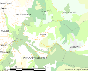
Сьево
- коммуна во Франции
Hiking in Сьево
Siévoz is a beautiful area in the French Alps, known for its scenic landscapes and hiking opportunities. If you're planning a hiking trip there, here are some key points to consider:...
- Страна:
- Почтовый код: 38350
- Координаты: 44° 54' 12" N, 5° 50' 15" E
- GPS треки (wikiloc): [Ссылка]
- Площадь: 7.37 кв.км
- Население: 136

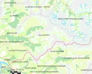
Вальжуффре
- коммуна во Франции
Hiking in Вальжуффре
Valjouffrey is a beautiful and lesser-known hiking destination located in the Isère department of the Auvergne-Rhône-Alpes region in France. Nestled in the heart of the Vercors Massif, Valjouffrey offers stunning landscapes characterized by dramatic peaks, lush valleys, and serene alpine lakes, making it a perfect spot for outdoor enthusiasts....
- Страна:
- Почтовый код: 38740
- Координаты: 44° 52' 20" N, 6° 1' 52" E
- GPS треки (wikiloc): [Ссылка]
- Высота над уровнем моря: 1014 м m
- Площадь: 72.56 кв.км
- Население: 145
- Веб сайт: [Ссылка]


Ле-Перье
- коммуна во Франции
Hiking in Ле-Перье
Le Périer is a charming village located in the Isère department of the Auvergne-Rhône-Alpes region in southeastern France. It's situated near the Vercors Regional Natural Park, which offers a variety of hiking opportunities for outdoor enthusiasts....
- Страна:
- Почтовый код: 38740
- Координаты: 44° 56' 13" N, 5° 58' 24" E
- GPS треки (wikiloc): [Ссылка]
- Площадь: 47.99 кв.км
- Население: 137


Ори-ан-Ратье
- коммуна во Франции
Hiking in Ори-ан-Ратье
Oris-en-Rattier is a charming little village in the Isère department in the Auvergne-Rhône-Alpes region of France. Nestled within the stunning landscapes of the French Alps, it offers a range of hiking opportunities for enthusiasts of all levels....
- Страна:
- Почтовый код: 38350
- Координаты: 44° 55' 16" N, 5° 52' 12" E
- GPS треки (wikiloc): [Ссылка]
- Площадь: 18.83 кв.км
- Население: 111

Антрег
- коммуна во Франции
Hiking in Антрег
Entraigues, located in the Isère department of the Auvergne-Rhône-Alpes region in southeastern France, is a charming village surrounded by beautiful natural landscapes, making it a great destination for hiking enthusiasts. Here are some key aspects to consider when planning your hike in this area:...
- Страна:
- Почтовый код: 38740
- Координаты: 44° 54' 6" N, 5° 56' 53" E
- GPS треки (wikiloc): [Ссылка]
- Высота над уровнем моря: 800 м m
- Площадь: 21.66 кв.км
- Население: 235
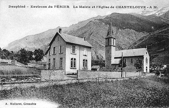

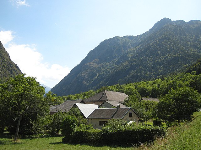
Шантлув
- коммуна во Франции
Hiking in Шантлув
Chantelouve, located in the Isère department of France, is a wonderful destination for hiking enthusiasts, especially those looking to explore the stunning landscapes of the French Alps. Here are some highlights and tips for hiking in this area:...
- Страна:
- Почтовый код: 38740
- Координаты: 44° 59' 2" N, 5° 58' 6" E
- GPS треки (wikiloc): [Ссылка]
- Площадь: 33.41 кв.км
- Население: 80
- Веб сайт: [Ссылка]

Ла-Морт
- коммуна во Франции
Hiking in Ла-Морт
La Morte, located in the French Alps, is a lesser-known but breathtaking area for hiking enthusiasts. It is characterized by its stunning landscapes, including rugged mountains, lush valleys, and pristine lakes. Here are some key points to consider when hiking in La Morte:...
- Страна:
- Почтовый код: 38350
- Координаты: 45° 1' 47" N, 5° 51' 22" E
- GPS треки (wikiloc): [Ссылка]
- Площадь: 19.45 кв.км
- Население: 133
- Веб сайт: [Ссылка]


Вальбонне
- коммуна во Франции
Hiking in Вальбонне
Valbonnais is a beautiful area located in the French Alps, specifically in the Isère department. It’s known for its stunning natural landscapes, diversity of hiking trails, and rich cultural heritage. Here’s what you need to know about hiking in Valbonnais:...
- Страна:
- Почтовый код: 38740
- Координаты: 44° 54' 0" N, 5° 54' 15" E
- GPS треки (wikiloc): [Ссылка]
- Площадь: 23.95 кв.км
- Население: 499
- Веб сайт: [Ссылка]