Étreval (Étreval)

- commune in Meurthe-et-Moselle, France
- Country:

- Postal Code: 54330
- Coordinates: 48° 27' 19" N, 6° 3' 5" E


- GPS tracks (wikiloc): [Link]
- Area: 2.37 sq km
- Population: 65
- Wikipedia en: wiki(en)
- Wikipedia: wiki(fr)
- Wikidata storage: Wikidata: Q287482
- Wikipedia Commons Category: [Link]
- Freebase ID: [/m/03qdgw9]
- Freebase ID: [/m/03qdgw9]
- GeoNames ID: Alt: [6436595]
- GeoNames ID: Alt: [6436595]
- SIREN number: [215401852]
- SIREN number: [215401852]
- INSEE municipality code: 54185
- INSEE municipality code: 54185
Shares border with regions:

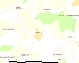
Chaouilley
- commune in Meurthe-et-Moselle, France
- Country:
- Postal Code: 54330
- Coordinates: 48° 26' 21" N, 6° 4' 5" E
- GPS tracks (wikiloc): [Link]
- Area: 5.12 sq km
- Population: 115


Vroncourt
- commune in Meurthe-et-Moselle, France
- Country:
- Postal Code: 54330
- Coordinates: 48° 27' 54" N, 6° 4' 49" E
- GPS tracks (wikiloc): [Link]
- Area: 4.16 sq km
- Population: 277

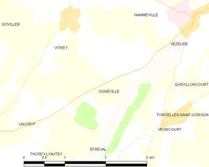
Ognéville
- commune in Meurthe-et-Moselle, France
- Country:
- Postal Code: 54330
- Coordinates: 48° 28' 30" N, 6° 3' 58" E
- GPS tracks (wikiloc): [Link]
- Area: 4.12 sq km
- Population: 105
- Web site: [Link]


Thorey-Lyautey
- commune in Meurthe-et-Moselle, France
- Country:
- Postal Code: 54115
- Coordinates: 48° 26' 35" N, 6° 1' 43" E
- GPS tracks (wikiloc): [Link]
- Area: 6.19 sq km
- Population: 140