
Aachen (Aachen)

.svg)
- city in North Rhine-Westphalia, Germany
 Hiking in Aachen
Aachen, located in western Germany near the borders with Belgium and the Netherlands, offers a variety of hiking opportunities that cater to different skill levels and preferences. Here are some key points about hiking in and around Aachen:
1.
- Hohes Venn: This nature reserve is part of the larger Eifel region and features a unique landscape of heathland, bogs, and woodlands. There are several marked trails that allow hikers to explore this beautiful natural area.
- Alte Vennbahnradweg: A former railway line that has been converted into a cycling and walking path. It offers a flat terrain, making it suitable for hikers of all levels, and connects Aachen with the picturesque countryside.
2.
- Aachen's rich history can be explored through its hiking paths, including routes that pass historical landmarks such as the Aachen Cathedral, a UNESCO World Heritage site, and the town's old city center.
3.
- Aachen's Stadtwald (City Forest): This urban forest provides a network of trails for walking and hiking. It’s perfect for short hikes and is accessible from the city.
- East Belgian Nature Park: Just a short distance from Aachen, this park offers diverse landscapes, including woodlands, meadows, and wetlands, with well-marked hiking routes.
4.
- Hiking is popular year-round, but best enjoyed in the spring and fall when temperatures are moderate and the landscapes are particularly beautiful. In winter, some paths can be muddy or icy, so proper footwear is recommended.
5.
- The region around Aachen is home to a variety of wildlife, including deer, various bird species, and unique flora. Expect to enjoy the sights and sounds of nature while hiking.
6.
- Many trails are well-marked and maintained, making it easier for both novice and experienced hikers to navigate. It’s advisable to carry a local map or use GPS tracking features on mobile devices for the best experience.
7.
- After a day of hiking, you’ll find plenty of cozy cafés and restaurants in Aachen where you can enjoy local cuisine and refresh yourself.
8.
- If you're new to the area or prefer organized hikes, consider joining guided hiking tours that offer insights into the natural and historical significance of the region.
Whether you are looking for a casual stroll or a more challenging hike, Aachen has something to offer. Just remember to check local trail conditions and weather forecasts before heading out. Happy hiking!
- Country:

- Postal Code: 52080; 52079; 52078; 52077; 52076; 52075; 52074; 52073; 52072; 52071; 52070; 52069; 52068; 52067; 52066; 52065; 52064; 52063; 52062
- Local Dialing Code: 02408; 02407; 02405; 02403; 0241
- Licence Plate Code: AC
- Coordinates: 50° 46' 34" N, 6° 5' 2" E


- GPS tracks (wikiloc): [Link]
- AboveSeaLevel: 125 м m
- Area: 160.85 sq km
- Population: 244951
- Web site: http://www.aachen.de/
- Wikipedia en: wiki(en)
- Wikipedia: wiki(de)
- Wikidata storage: Wikidata: Q1017
- Wikipedia Commons Gallery: [Link]
- Wikipedia Commons Category: [Link]
- Wikipedia Commons Maps Category: [Link]
- Freebase ID: [/m/0qjd]
- GeoNames ID: Alt: [3247449]
- BnF ID: [11865908c]
- VIAF ID: Alt: [124330404]
- OSM relation ID: [62564]
- GND ID: Alt: [4000003-5]
- archINFORM location ID: [381]
- Library of Congress authority ID: Alt: [n80046295]
- PACTOLS thesaurus ID: [pcrtyWocDktVkc]
- MusicBrainz area ID: [bf5d41ea-2772-403f-9d6a-c4fade30a2ae]
- WOEID: [633175]
- Quora topic ID: [Aachen-Germany-1]
- TGN ID: [7004799]
- SUDOC authorities ID: [026405865]
- Encyclopædia Britannica Online ID: [place/Aachen]
- Gran Enciclopèdia Catalana ID: [0004606]
- Encyclopædia Universalis ID: [aix-la-chapelle-histoire-de-l-art-et-archeologie]
- Historical Gazetteer (GOV) ID: [AACHENJO30BS]
- EMLO location ID: [6e2fd318-9a91-44d4-b478-a0f874b2996e]
- Facebook Places ID: [110758342277781]
- Great Russian Encyclopedia Online ID: [1842331]
- Digital Atlas of the Roman Empire ID: [363]
- ISNI: Alt: [0000 0001 2097 3385]
- NKCR AUT ID: [ge134535]
- DMOZ ID: Alt: [Regional/Europe/Germany/States/North_Rhine-Westphalia/Localities/Aachen/]
- National Library of Israel ID: [000979115]
- NUTS code: [DEA21]
- YSO ID: [188863]
- Nomisma ID: [aachen]
- Klexikon article ID: [Aachen]
- BabelNet ID: [00000174n]
- Brockhaus Enzyklopädie online ID: [aachen-40]
- Global Anabaptist Mennonite Encyclopedia Online ID: [Aachen (Nordrhein-Westfalen, Germany)]
- FAST ID: [1208397]
- Catholic Encyclopedia ID: [01001a]
- BNE ID: Alt: [XX458734]
- Canadiana Authorities ID: [0500L7658]
- NSK ID: [000587911]
- BAV ID: [ADV12247284]
- Orthodox Encyclopedia ID: [77174]
- Instagram username: [stadtaachen]
- CERL ID: [cnl00006597]
- OmegaWiki Defined Meaning: [503491]
- German municipality key: 05334002
- US National Archives Identifier: 10044717
- LAU: 05334002
Includes regions:

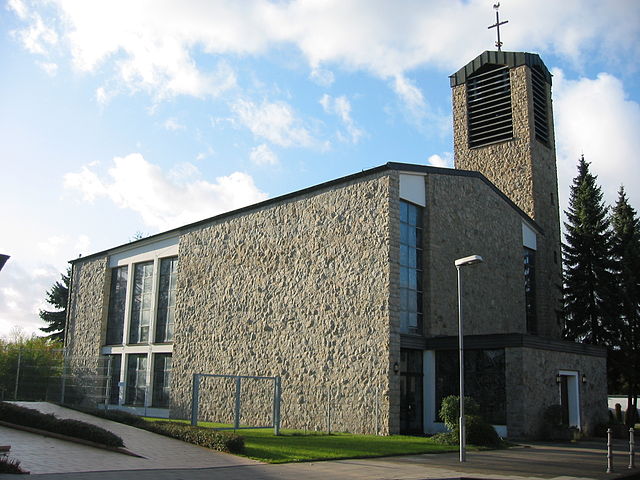
Eilendorf
- human settlement in Germany
Hiking in Eilendorf
Eilendorf, a district in Aachen, Germany, offers several opportunities for hiking enthusiasts to explore the beautiful natural surroundings. While Eilendorf itself is a small area, it is well-connected to larger hiking trails and scenic routes that take you through the picturesque landscape of North Rhine-Westphalia....
- Country:
- Postal Code: 52080
- Local Dialing Code: 0241
- Coordinates: 50° 46' 46" N, 6° 9' 45" E
- GPS tracks (wikiloc): [Link]
- AboveSeaLevel: 196 м m
- Area: 6.84 sq km
- Population: 15376
- Web site: [Link]
Brand
- district of Aachen, Germany
Hiking in Brand
Brand is a charming district located on the outskirts of Aachen, Germany, known for its beautiful landscapes and outdoor opportunities. Hiking in the area offers a blend of scenic views, historical landmarks, and the chance to explore nature. Here are some highlights and tips for hiking in Brand:...
- Country:
- Postal Code: 52078; 52076
- Local Dialing Code: 0241
- Coordinates: 50° 44' 56" N, 6° 9' 54" E
- GPS tracks (wikiloc): [Link]
- AboveSeaLevel: 262 м m
- Population: 17063

Haaren
- District of Aachen, Germany
Hiking in Haaren
Haaren, a district of Aachen in Germany, is situated near the borders with Belgium and the Netherlands, providing hikers with a beautiful natural setting for outdoor adventures. The region's landscape features rolling hills, lush forests, and scenic trails that are perfect for hiking....
- Country:
- Postal Code: 52070; 52068
- Local Dialing Code: 0241
- Coordinates: 50° 47' 44" N, 6° 7' 37" E
- GPS tracks (wikiloc): [Link]
- Area: 8.80 sq km
- Population: 12216

Laurensberg
- human settlement in Germany
Hiking in Laurensberg
Laurensberg is a district in the city of Aachen, Germany, known for its beautiful natural surroundings and access to hiking trails. While the district itself may not offer extensive hiking options, it serves as a gateway to the broader landscapes of the region. Here are some highlights and tips for hiking in and around Laurensberg:...
- Country:
- Postal Code: 52072; 52074
- Local Dialing Code: 0241
- Coordinates: 50° 47' 50" N, 6° 3' 46" E
- GPS tracks (wikiloc): [Link]
- AboveSeaLevel: 163 м m
- Area: 29.97 sq km
- Population: 19380
Richterich
- human settlement in Germany
Hiking in Richterich
Richterich is a district in the city of Aachen, located in North Rhine-Westphalia, Germany. While it may not be primarily known for extensive hiking trails, there are several nearby areas that offer great opportunities for hiking enthusiasts....
- Country:
- Postal Code: 52072
- Local Dialing Code: 0241
- Coordinates: 50° 48' 31" N, 6° 3' 45" E
- GPS tracks (wikiloc): [Link]
- AboveSeaLevel: 186 м m
- Area: 13.18 sq km
- Population: 8701
Kornelimünster/Walheim
- stadtbezirk of Aachen in North Rhine-Westphalia, Germany
Hiking in Kornelimünster/Walheim
Kornelimünster-Walheim is a picturesque area located near Aachen in Germany, known for its beautiful landscapes and charming village ambiance. Hiking in this region can be a delightful experience, offering a variety of trails that wind through lush forests, rolling hills, and serene meadows. Here are some highlights and tips for hiking in this area:...
- Country:
- Postal Code: 52076
- Local Dialing Code: 02408
- Coordinates: 50° 43' 17" N, 6° 10' 49" E
- GPS tracks (wikiloc): [Link]
- AboveSeaLevel: 240 м m
- Area: 37.03 sq km

Aachen-Mitte
- human settlement in Germany
Hiking in Aachen-Mitte
Aachen-Mitte, located in Germany, is an excellent area for hiking enthusiasts. While the city itself is more urban, it offers access to trails and nearby natural settings that can be explored. Here are some highlights about hiking in and around Aachen-Mitte:...
- Country:
- Postal Code: 52066; 52064; 52062
- Local Dialing Code: 0241
- Coordinates: 50° 46' 30" N, 6° 5' 3" E
- GPS tracks (wikiloc): [Link]
- AboveSeaLevel: 170 м m
Shares border with regions:


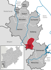
Würselen
- city in the district of Aachen, in North Rhine-Westphalia, Germany
Hiking in Würselen
Würselen is a town in North Rhine-Westphalia, Germany, located near the city of Aachen. While it may not be as famous as some other hiking destinations, it offers a variety of trails and natural landscapes that make it a lovely place for hiking enthusiasts. Here are some key points about hiking in and around Würselen:...
- Country:
- Postal Code: 52146
- Local Dialing Code: 02406; 02405
- Licence Plate Code: AC
- Coordinates: 50° 49' 29" N, 6° 7' 39" E
- GPS tracks (wikiloc): [Link]
- AboveSeaLevel: 170 м m
- Area: 34.39 sq km
- Population: 38934
- Web site: [Link]

Roetgen
- municipality in the district of Aachen, in North Rhine-Westphalia, Germany
Hiking in Roetgen
Roetgen, located in North Rhine-Westphalia, Germany, is a picturesque town that serves as an excellent base for hiking enthusiasts. Nestled near the border with Belgium and surrounded by the stunning landscapes of the Eifel region, it offers a variety of trails suitable for different skill levels. Here are some highlights for hiking in Roetgen:...
- Country:
- Postal Code: 52159
- Local Dialing Code: 02471
- Licence Plate Code: AC
- Coordinates: 50° 39' 0" N, 6° 12' 0" E
- GPS tracks (wikiloc): [Link]
- AboveSeaLevel: 410 м m
- Area: 39.03 sq km
- Population: 8625
- Web site: [Link]
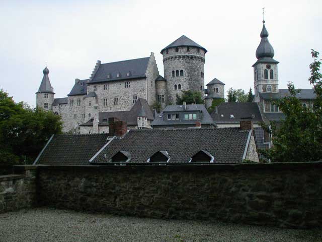

Stolberg
- city in the district of Aachen, in North Rhine-Westphalia, Germany
Hiking in Stolberg
Stolberg is located in the Rhineland region of Germany and is surrounded by beautiful landscapes that are perfect for hiking enthusiasts. Here are some highlights and tips for hiking in and around Stolberg:...
- Country:
- Postal Code: 52224; 52223; 52222
- Local Dialing Code: 02409; 02408; 02402
- Licence Plate Code: AC
- Coordinates: 50° 46' 0" N, 6° 14' 0" E
- GPS tracks (wikiloc): [Link]
- AboveSeaLevel: 260 м m
- Area: 98.48 sq km
- Population: 56751
- Web site: [Link]

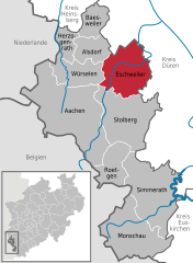
Eschweiler
- city in the district of Aachen, in North Rhine-Westphalia, Germany
Hiking in Eschweiler
Eschweiler, located in the North Rhine-Westphalia region of Germany, offers a variety of hiking opportunities for outdoor enthusiasts. The surrounding landscapes feature scenic views, including lush forests, rolling hills, and rivers, which can provide a wonderful backdrop for your hiking adventures....
- Country:
- Postal Code: 52249
- Local Dialing Code: 02403
- Licence Plate Code: AC, MON
- Coordinates: 50° 49' 0" N, 6° 17' 0" E
- GPS tracks (wikiloc): [Link]
- AboveSeaLevel: 135 м m
- Area: 75.87 sq km
- Population: 56207
- Web site: [Link]


Herzogenrath
- city in the district of Aachen, in North Rhine-Westphalia, Germany
Hiking in Herzogenrath
Herzogenrath, located in North Rhine-Westphalia, Germany, offers a variety of hiking opportunities for outdoor enthusiasts. The region is characterized by its lush landscapes, tranquil forests, and scenic trails, making it a great destination for both casual walkers and more experienced hikers....
- Country:
- Postal Code: 52134
- Local Dialing Code: 02407; 02406
- Licence Plate Code: AC
- Coordinates: 50° 52' 0" N, 6° 6' 0" E
- GPS tracks (wikiloc): [Link]
- AboveSeaLevel: 140 м m
- Area: 33.38 sq km
- Population: 46462
- Web site: [Link]