
Roetgen (Roetgen)

.svg)
- municipality in the district of Aachen, in North Rhine-Westphalia, Germany
 Hiking in Roetgen
Roetgen, located in North Rhine-Westphalia, Germany, is a picturesque town that serves as an excellent base for hiking enthusiasts. Nestled near the border with Belgium and surrounded by the stunning landscapes of the Eifel region, it offers a variety of trails suitable for different skill levels. Here are some highlights for hiking in Roetgen:
Hiking Trails
-
Rothaarsteig Trail: This long-distance hiking trail runs through the beautiful Eifel region and offers stunning views, dense forests, and diverse flora and fauna. It’s well-marked, making it suitable for both novice and experienced hikers.
-
Eifel National Park: Just a short distance from Roetgen, this park has numerous trails that take you through ancient woodlands, along rivers, and up to scenic viewpoints. The park is known for its rich biodiversity and is a great spot for birdwatching.
-
Langenfeld Trail: This is a shorter, family-friendly trail that takes you through the idyllic countryside surrounding Roetgen. It's perfect for leisurely walks, offering a chance to enjoy the local flora and fauna.
Tips for Hiking in Roetgen
- Trail Markings: Most trails in the area are well-marked with signs and symbols, but it’s a good idea to carry a map or download a hiking app for your smartphone for extra navigation support.
- Weather Considerations: The weather can change rapidly in the Eifel region, so be sure to check forecasts and dress in layers. Bring waterproof gear if there might be rain.
- Equipment: Good hiking boots are essential for the often uneven terrain. A hiking pole might also be helpful, especially on steeper sections.
- Local Amenities: Roetgen has local shops where you can stop for refreshments or pack a picnic to enjoy during your hike.
Additional Activities
In addition to hiking, Roetgen is close to various attractions such as cycling paths, and it offers cultural experiences in local towns, making it a well-rounded destination for outdoor and leisure activities.
Whether you’re looking for a challenging hike or a peaceful walk in nature, Roetgen and its surroundings provide an array of options for outdoor adventures. Enjoy your time exploring this beautiful part of Germany!
- Country:

- Postal Code: 52159
- Local Dialing Code: 02471
- Licence Plate Code: AC
- Coordinates: 50° 39' 0" N, 6° 12' 0" E


- GPS tracks (wikiloc): [Link]
- AboveSeaLevel: 410 м m
- Area: 39.03 sq km
- Population: 8625
- Web site: https://www.roetgen.de/
- Wikipedia en: wiki(en)
- Wikipedia: wiki(de)
- Wikidata storage: Wikidata: Q200743
- Wikipedia Commons Category: [Link]
- Freebase ID: [/m/0bfht1]
- GeoNames ID: Alt: [6553051]
- BnF ID: [16715285c]
- VIAF ID: Alt: [154811356]
- OSM relation ID: [158018]
- GND ID: Alt: [4050358-6]
- archINFORM location ID: [9792]
- Library of Congress authority ID: Alt: [n83189571]
- MusicBrainz area ID: [fc155a79-b641-43ae-9d27-7db96e14f4db]
- WOEID: [689833]
- Historical Gazetteer (GOV) ID: [ROEGENJO30CP]
- DMOZ ID: Alt: [World/Deutsch/Regional/Europa/Deutschland/Nordrhein-Westfalen/Landkreise/Städteregion_Aachen/Städte_und_Gemeinden/Roetgen/]
- National Library of Israel ID: [001000880]
- FAST ID: [1226014]
- German municipality key: 05334024
- GNS Unique Feature ID: -1852683
Shares border with regions:

Aachen
- city in North Rhine-Westphalia, Germany
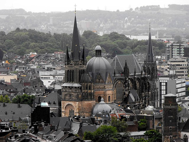
Hiking in Aachen
Aachen, located in western Germany near the borders with Belgium and the Netherlands, offers a variety of hiking opportunities that cater to different skill levels and preferences. Here are some key points about hiking in and around Aachen:...
- Country:
- Postal Code: 52080; 52079; 52078; 52077; 52076; 52075; 52074; 52073; 52072; 52071; 52070; 52069; 52068; 52067; 52066; 52065; 52064; 52063; 52062
- Local Dialing Code: 02408; 02407; 02405; 02403; 0241
- Licence Plate Code: AC
- Coordinates: 50° 46' 34" N, 6° 5' 2" E
- GPS tracks (wikiloc): [Link]
- AboveSeaLevel: 125 м m
- Area: 160.85 sq km
- Population: 244951
- Web site: [Link]


Simmerath
- municipality in the district of Aachen, in North Rhine-Westphalia, Germany
Hiking in Simmerath
Simmerath is a picturesque town located in the Eifel region of Germany, known for its stunning landscapes and rich natural beauty, making it an excellent destination for hiking enthusiasts. Here are some highlights regarding hiking in and around Simmerath:...
- Country:
- Postal Code: 52152
- Local Dialing Code: 02473
- Licence Plate Code: AC
- Coordinates: 50° 36' 0" N, 6° 17' 59" E
- GPS tracks (wikiloc): [Link]
- AboveSeaLevel: 280 м m
- Area: 110.92 sq km
- Population: 15094
- Web site: [Link]

Stolberg
- city in the district of Aachen, in North Rhine-Westphalia, Germany
Hiking in Stolberg
Stolberg is located in the Rhineland region of Germany and is surrounded by beautiful landscapes that are perfect for hiking enthusiasts. Here are some highlights and tips for hiking in and around Stolberg:...
- Country:
- Postal Code: 52224; 52223; 52222
- Local Dialing Code: 02409; 02408; 02402
- Licence Plate Code: AC
- Coordinates: 50° 46' 0" N, 6° 14' 0" E
- GPS tracks (wikiloc): [Link]
- AboveSeaLevel: 260 м m
- Area: 98.48 sq km
- Population: 56751
- Web site: [Link]