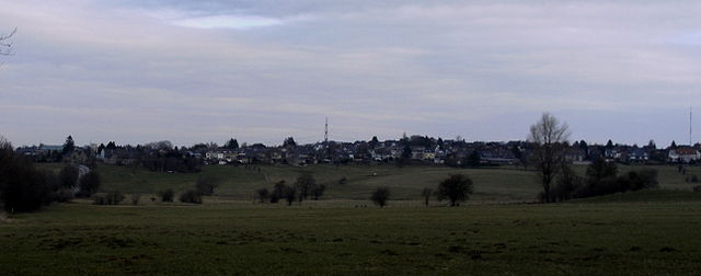
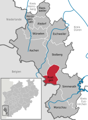
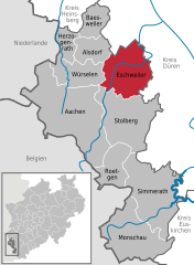
Stolberg (Stolberg)
.svg)
- city in the district of Aachen, in North Rhine-Westphalia, Germany
 Hiking in Stolberg
Stolberg is located in the Rhineland region of Germany and is surrounded by beautiful landscapes that are perfect for hiking enthusiasts. Here are some highlights and tips for hiking in and around Stolberg:
1.
- Stolberg is situated near the foothills of the Eifel Mountains, offering numerous trails that cater to different skill levels.
- The area boasts diverse landscapes including forests, streams, and hills, providing picturesque views throughout your hike.
2.
- Rur River Trails: These trails follow the winding Rur River and offer beautiful views of the water and surrounding nature.
- Eifel National Park: A short drive from Stolberg, this park offers well-marked trails that take you through untouched nature, showcasing the unique flora and fauna of the region.
- Historic Town Walks: Explore Stolberg’s charming old town with its medieval buildings, including the famous Stolberg Castle, which makes for a great addition to a hiking itinerary.
3.
- Gear Up: Ensure you have appropriate hiking gear, including sturdy footwear, weather-appropriate clothing, and a backpack with essentials like water and snacks.
- Navigation: While trails are generally well-marked, consider bringing a map or using a hiking app on your phone to stay on track.
- Safety First: Always let someone know your hiking plans, stay hydrated, and be aware of your surroundings, especially when hiking in more wooded areas.
4.
- Spring and autumn are particularly beautiful times to hike in Stolberg, thanks to mild weather and vibrant scenery. Summer can also be good, but be prepared for hotter temperatures.
5.
- Besides hiking, Stolberg offers rich history and culture. Be sure to explore local museums and cafes in the town after a day of hiking.
Overall, Stolberg offers an enriching hiking experience with its combination of natural beauty and historical significance. Always check local regulations and trail conditions before heading out. Happy hiking!
- Country:

- Postal Code: 52224; 52223; 52222
- Local Dialing Code: 02409; 02408; 02402
- Licence Plate Code: AC
- Coordinates: 50° 46' 0" N, 6° 14' 0" E


- GPS tracks (wikiloc): [Link]
- AboveSeaLevel: 260 м m
- Area: 98.48 sq km
- Population: 56751
- Web site: https://www.stolberg.de/
- Wikipedia en: wiki(en)
- Wikipedia: wiki(de)
- Wikidata storage: Wikidata: Q4068
- Wikipedia Commons Gallery: [Link]
- Wikipedia Commons Category: [Link]
- Wikipedia Commons Maps Category: [Link]
- Freebase ID: [/m/07545c]
- GeoNames ID: Alt: [2826595]
- BnF ID: [153423742]
- VIAF ID: Alt: [248486002]
- OSM relation ID: [157996]
- GND ID: Alt: [4057714-4]
- archINFORM location ID: [11519]
- Library of Congress authority ID: Alt: [n84234651]
- MusicBrainz area ID: [f3c9383c-0d3d-45cb-a8ab-ef4921078ecd]
- Historical Gazetteer (GOV) ID: [STOERGJO30CS]
- Facebook Places ID: [109524912405898]
- Digital Atlas of the Roman Empire ID: [19702]
- DMOZ ID: Alt: [World/Deutsch/Regional/Europa/Deutschland/Nordrhein-Westfalen/Landkreise/Städteregion_Aachen/Städte_und_Gemeinden/Stolberg,_Rheinland/]
- National Library of Israel ID: [001006605]
- FAST ID: [1314782]
- CERL ID: [cnl00014379]
- German municipality key: 05334032
- US National Archives Identifier: 10045670
Includes regions:
Büsbach
- human settlement in Germany
Hiking in Büsbach
Büsbach is a charming area in Germany, often recognized for its scenic landscapes and natural beauty. If you’re considering hiking in Büsbach, here are some key points to keep in mind:...
- Country:
- Coordinates: 50° 45' 2" N, 6° 12' 50" E
- GPS tracks (wikiloc): [Link]
- AboveSeaLevel: 258 м m
- Population: 7200

Oberstolberg
- human settlement in Germany
Hiking in Oberstolberg
Oberstolberg is a picturesque area located in the North Rhine-Westphalia region of Germany, well-known for its stunning landscapes and rich natural beauty. Hiking in this region offers a mix of forest trails, hilly terrains, and scenic viewpoints, ideal for both short walks and longer treks....
- Country:
- Coordinates: 50° 46' 2" N, 6° 14' 3" E
- GPS tracks (wikiloc): [Link]
- AboveSeaLevel: 228 м m

Zweifall
- human settlement in Germany
Hiking in Zweifall
Zweifall is a beautiful area located in the northwestern part of Germany, within the state of North Rhine-Westphalia. It is known for its picturesque landscapes, lush forests, and diverse hiking trails that cater to various skill levels. Here are some highlights and tips for hiking in Zweifall:...
- Country:
- Postal Code: 52224
- Local Dialing Code: 02402
- Coordinates: 50° 43' 5" N, 6° 15' 25" E
- GPS tracks (wikiloc): [Link]
- AboveSeaLevel: 253 м m
- Area: 20.37 sq km
Vicht
- human settlement in Germany
Hiking in Vicht
Hiking in Vicht, which is a district of Stolberg in Germany, offers a variety of scenic trails and beautiful landscapes, making it a great destination for outdoor enthusiasts. The area is characterized by its rolling hills, forests, and charming rural scenery....
- Country:
- Postal Code: 52224
- Local Dialing Code: 02402
- Coordinates: 50° 44' 37" N, 6° 15' 57" E
- GPS tracks (wikiloc): [Link]
- AboveSeaLevel: 218 м m

Mausbach
- borough of Stolberg (Rhineland), Germany
Hiking in Mausbach
Mausbach, located in the Stolberg area of North Rhine-Westphalia, Germany, is a beautiful destination for hikers looking for a blend of nature, history, and scenic views. This region is characterized by its lush forests, rolling hills, and a network of well-marked trails that cater to various skill levels....
- Country:
- Postal Code: 52224
- Local Dialing Code: 02402
- Coordinates: 50° 45' 28" N, 6° 16' 40" E
- GPS tracks (wikiloc): [Link]
- AboveSeaLevel: 294 м m
Münsterbusch
- human settlement in Germany
Hiking in Münsterbusch
Münsterbusch is a picturesque area located in Germany, often noted for its serene natural landscapes and scenic trails. While it might not be one of the most widely recognized hiking destinations, it's appreciated for its tranquil environment, making it suitable for both casual walkers and dedicated hikers....
- Country:
- Postal Code: 52223
- Local Dialing Code: 02402
- Coordinates: 50° 46' 7" N, 6° 12' 50" E
- GPS tracks (wikiloc): [Link]
- AboveSeaLevel: 230 м m
Unterstolberg
- human settlement in Germany
Hiking in Unterstolberg
Unterstolberg is a charming town located in the state of Saxony-Anhalt in Germany. The surrounding region offers a variety of hiking opportunities, making it an appealing destination for outdoor enthusiasts....
- Country:
- Postal Code: 52222
- Local Dialing Code: 02402
- Coordinates: 50° 46' 35" N, 6° 13' 26" E
- GPS tracks (wikiloc): [Link]
- AboveSeaLevel: 173 м m

Atsch
- district of Aachen, Germany
Hiking in Atsch
Atsch, often known for its stunning natural landscapes, offers a variety of hiking opportunities for outdoor enthusiasts. When planning a hike in the area, here are some key points to consider:...
- Country:
- Local Dialing Code: 02402
- Coordinates: 50° 47' 3" N, 6° 12' 17" E
- GPS tracks (wikiloc): [Link]
- AboveSeaLevel: 194 м m
Schevenhütte
- human settlement in Germany
Hiking in Schevenhütte
Schevenhütte, located in the German state of Rhineland-Palatinate, is a great starting point for hiking enthusiasts looking to explore the scenic beauty of the surrounding region. Positioned near the Palatinate Forest, it serves as a gateway to numerous hiking trails that offer stunning views, diverse landscapes, and opportunities to experience local flora and fauna....
- Country:
- Postal Code: 52224
- Local Dialing Code: 02409
- Coordinates: 50° 46' 10" N, 6° 19' 31" E
- GPS tracks (wikiloc): [Link]
- AboveSeaLevel: 189 м m
Vicht-Breinigerberg
- human settlement in Germany
Hiking in Vicht-Breinigerberg
Vicht-Breinigerberg, located in Germany's North Rhine-Westphalia region, offers a variety of hiking opportunities amid beautiful landscapes. The area is characterized by rolling hills, forests, and picturesque views, making it an excellent destination for both casual walkers and avid hikers....
- Country:
- Coordinates: 50° 44' 13" N, 6° 14' 6" E
- GPS tracks (wikiloc): [Link]
- AboveSeaLevel: 275 м m

Breinig
- human settlement in Germany
Hiking in Breinig
Breinig, located in Pennsylvania, offers some great opportunities for hiking enthusiasts, particularly in the surrounding areas of the Appalachian region. Here are some highlights to consider:...
- Country:
- Postal Code: 52223
- Local Dialing Code: 02402
- Coordinates: 50° 43' 54" N, 6° 12' 35" E
- GPS tracks (wikiloc): [Link]
- AboveSeaLevel: 280 м m
Gressenich
- human settlement in Germany
Hiking in Gressenich
Gressenich is a small village in the municipality of Baesweiler, located in North Rhine-Westphalia, Germany. While Gressenich itself may not be a major hiking destination, the surrounding areas offer several opportunities for hiking and outdoor activities. Here are some key points to consider when planning a hiking experience around Gressenich:...
- Country:
- Postal Code: 52224
- Local Dialing Code: 02409
- Coordinates: 50° 46' 22" N, 6° 18' 1" E
- GPS tracks (wikiloc): [Link]
- AboveSeaLevel: 213 м m
Venwegen
- human settlement in Germany
Hiking in Venwegen
Venwegen, a small village located in the Netherlands, is often associated with tranquil landscapes and rural charm, which can provide a peaceful hiking experience. While it may not be as well-known for hiking as larger national parks or mountainous regions, the surrounding areas offer opportunities for those looking to enjoy nature on foot....
- Country:
- Postal Code: 52224
- Local Dialing Code: 02408
- Coordinates: 50° 42' 48" N, 6° 12' 53" E
- GPS tracks (wikiloc): [Link]
- AboveSeaLevel: 279 м m

Donnerberg
- human settlement in Germany
Hiking in Donnerberg
Donnerberg is a district located in the city of Siegen, North Rhine-Westphalia, Germany. This area is rich in natural beauty, offering opportunities for hiking and outdoor activities. While specific hiking trails can vary, here are some general tips and highlights for hiking in the Donnerberg area:...
- Country:
- Coordinates: 50° 46' 48" N, 6° 14' 20" E
- GPS tracks (wikiloc): [Link]
Werth
- human settlement in Germany
Hiking in Werth
Werth is a charming village located in the Stolberg municipality in Germany, nestled within the picturesque Harz Mountains region. The area surrounding Werth offers beautiful landscapes, rich natural diversity, and a variety of hiking trails suitable for different skill levels....
- Country:
- Postal Code: 52224
- Local Dialing Code: 02409
- Coordinates: 50° 46' 50" N, 6° 16' 56" E
- GPS tracks (wikiloc): [Link]
- AboveSeaLevel: 240 м m
Dorff
- human settlement in Germany
Hiking in Dorff
It seems there might be a bit of confusion, as "Dorff" isn't widely recognized as a specific hiking destination. However, if you meant a place like "Dorf," "Dorfleben," or perhaps a specific area known colloquially as Dorff, I can offer general advice on how to explore hiking in small villages or rural areas....
- Country:
- Postal Code: 52223
- Local Dialing Code: 02402
- Coordinates: 50° 44' 25" N, 6° 12' 2" E
- GPS tracks (wikiloc): [Link]
- AboveSeaLevel: 260 м m

Breinigerberg
- village of Stolberg, Germany
Hiking in Breinigerberg
Breinigerberg, located in the region of North Rhine-Westphalia in Germany, offers a delightful hiking experience amidst beautiful natural landscapes. This area is part of the Eifel mountain range and is characterized by rolling hills, lush forests, and scenic views that make it a popular destination for outdoor enthusiasts....
- Country:
- Postal Code: 52223
- Coordinates: 50° 44' 0" N, 6° 14' 0" E
- GPS tracks (wikiloc): [Link]
- AboveSeaLevel: 276 м m
- Population: 971
- Web site: [Link]
Shares border with regions:
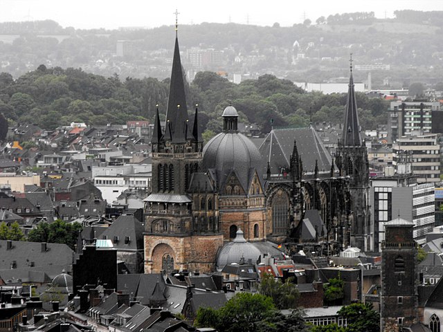

Aachen
- city in North Rhine-Westphalia, Germany
Hiking in Aachen
Aachen, located in western Germany near the borders with Belgium and the Netherlands, offers a variety of hiking opportunities that cater to different skill levels and preferences. Here are some key points about hiking in and around Aachen:...
- Country:
- Postal Code: 52080; 52079; 52078; 52077; 52076; 52075; 52074; 52073; 52072; 52071; 52070; 52069; 52068; 52067; 52066; 52065; 52064; 52063; 52062
- Local Dialing Code: 02408; 02407; 02405; 02403; 0241
- Licence Plate Code: AC
- Coordinates: 50° 46' 34" N, 6° 5' 2" E
- GPS tracks (wikiloc): [Link]
- AboveSeaLevel: 125 м m
- Area: 160.85 sq km
- Population: 244951
- Web site: [Link]
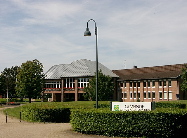

Hürtgenwald
- municipality in the Düren district, in North Rhine-Westphalia, Germany
Hiking in Hürtgenwald
Hürtgenwald, located in North Rhine-Westphalia, Germany, is known for its lush forests, rolling hills, and rich history, making it a fantastic destination for hikers. The area is characterized by its dense woodlands and diverse flora and fauna, offering a peaceful environment for outdoor enthusiasts. Here’s what you need to know about hiking in Hürtgenwald:...
- Country:
- Postal Code: 52393
- Local Dialing Code: 02429
- Licence Plate Code: DN
- Coordinates: 50° 43' 0" N, 6° 22' 0" E
- GPS tracks (wikiloc): [Link]
- AboveSeaLevel: 380 м m
- Area: 88.05 sq km
- Population: 8644
- Web site: [Link]


Langerwehe
- municipality in the Düren district, in North Rhine-Westphalia, Germany
Hiking in Langerwehe
Langerwehe is a small town located in North Rhine-Westphalia, Germany, nestled in the picturesque area of the Rureifel region. While it might not be as well-known as larger hiking destinations, it offers several enjoyable trails that are suitable for different skill levels....
- Country:
- Postal Code: 52379
- Local Dialing Code: 02423
- Licence Plate Code: DN
- Coordinates: 50° 49' 0" N, 6° 20' 59" E
- GPS tracks (wikiloc): [Link]
- AboveSeaLevel: 158 м m
- Area: 41.49 sq km
- Population: 13986
- Web site: [Link]

Roetgen
- municipality in the district of Aachen, in North Rhine-Westphalia, Germany
Hiking in Roetgen
Roetgen, located in North Rhine-Westphalia, Germany, is a picturesque town that serves as an excellent base for hiking enthusiasts. Nestled near the border with Belgium and surrounded by the stunning landscapes of the Eifel region, it offers a variety of trails suitable for different skill levels. Here are some highlights for hiking in Roetgen:...
- Country:
- Postal Code: 52159
- Local Dialing Code: 02471
- Licence Plate Code: AC
- Coordinates: 50° 39' 0" N, 6° 12' 0" E
- GPS tracks (wikiloc): [Link]
- AboveSeaLevel: 410 м m
- Area: 39.03 sq km
- Population: 8625
- Web site: [Link]


Simmerath
- municipality in the district of Aachen, in North Rhine-Westphalia, Germany
Hiking in Simmerath
Simmerath is a picturesque town located in the Eifel region of Germany, known for its stunning landscapes and rich natural beauty, making it an excellent destination for hiking enthusiasts. Here are some highlights regarding hiking in and around Simmerath:...
- Country:
- Postal Code: 52152
- Local Dialing Code: 02473
- Licence Plate Code: AC
- Coordinates: 50° 36' 0" N, 6° 17' 59" E
- GPS tracks (wikiloc): [Link]
- AboveSeaLevel: 280 м m
- Area: 110.92 sq km
- Population: 15094
- Web site: [Link]

Eschweiler
- city in the district of Aachen, in North Rhine-Westphalia, Germany
Hiking in Eschweiler
Eschweiler, located in the North Rhine-Westphalia region of Germany, offers a variety of hiking opportunities for outdoor enthusiasts. The surrounding landscapes feature scenic views, including lush forests, rolling hills, and rivers, which can provide a wonderful backdrop for your hiking adventures....
- Country:
- Postal Code: 52249
- Local Dialing Code: 02403
- Licence Plate Code: AC, MON
- Coordinates: 50° 49' 0" N, 6° 17' 0" E
- GPS tracks (wikiloc): [Link]
- AboveSeaLevel: 135 м m
- Area: 75.87 sq km
- Population: 56207
- Web site: [Link]