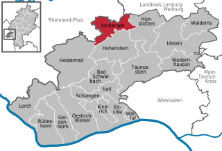
Aarbergen (Aarbergen)
- Rheingau-Taunus municipality in Hesse, Germany
Aarbergen, a picturesque municipality in the Rhine Valley of Germany, offers a variety of hiking opportunities that cater to different skill levels and preferences. Nestled within the scenic landscapes of the Taunus Mountains, hikers can enjoy lush forests, rolling hills, and stunning views of the surrounding countryside.
Recommended Hiking Trails
-
Aarbergen Circular Route:
- This trail provides a lovely way to explore the countryside around Aarbergen. It typically combines paths through forests and fields, offering a chance to enjoy both nature and the quaint charm of the local villages.
-
The Naturpark Rhein-Taunus:
- Parts of Aarbergen fall within this natural park, which features numerous well-marked trails. Hikers can experience diverse landscapes and rich flora and fauna. Trails vary in length and difficulty, making it family-friendly while also challenging for experienced hikers.
-
Lahn Valley Trails:
- The nearby Lahn River offers beautiful trails that follow the riverside. The routes vary from easy walks to more challenging hikes that ascend into the hills and offer panoramic views.
Tips for Hiking in Aarbergen
- Preparation: Before heading out, make sure to check the weather forecast and dress in layers. The weather can change quickly in the hills.
- Navigation: Although many trails are well-marked, carrying a map or a GPS device is wise. Familiarize yourself with the routes beforehand, especially if you're venturing on less traveled paths.
- Hydration and Snacks: Always carry enough water and some snacks, especially if you're planning to hike for several hours.
- Respect Nature: Stay on marked trails to protect the environment and wildlife. Carry out any trash you bring with you.
- Safety: If you're hiking alone, let someone know your planned route and expected return time.
Best Time to Visit
The best time to hike in Aarbergen is during the spring and fall when temperatures are mild, and the scenery is vibrant. Summer can be warm, and winters may bring snow, which could make some trails more challenging.
In summary, hiking in Aarbergen offers a delightful experience for nature lovers, with options ranging from leisurely walks to more strenuous treks. Whether you're looking for a day trip or a more extended adventure, Aarbergen and its surroundings have much to offer.
- Country:

- Postal Code: 65326
- Local Dialing Code: 06120
- Coordinates: 50° 14' 47" N, 8° 4' 20" E


- GPS tracks (wikiloc): [Link]
- AboveSeaLevel: 230 м m
- Area: 33.94 sq km
- Population: 6082
- Web site: http://www.aarbergen.de/
- Wikipedia en: wiki(en)
- Wikipedia: wiki(de)
- Wikidata storage: Wikidata: Q301056
- Wikipedia Commons Category: [Link]
- Freebase ID: [/m/02vvmgm]
- GeoNames ID: Alt: [3208019]
- VIAF ID: Alt: [152564765]
- OSM relation ID: [413109]
- GND ID: Alt: [4260205-1]
- Library of Congress authority ID: Alt: [n89119174]
- Historical Gazetteer (GOV) ID: [AARGENJO40BF]
- German municipality key: 06439001
Includes regions:
Daisbach
- municipal district of Aarbergen in Rheingau-Taunus-Kreis, Germany
Daisbach, a part of Aarbergen in Hesse, Germany, offers a lovely setting for hiking enthusiasts. The region is characterized by picturesque landscapes, dense forests, and charming rural scenery, making it an ideal spot for outdoor activities....
- Country:

- Postal Code: 65326
- Local Dialing Code: 06120
- Coordinates: 50° 14' 55" N, 8° 6' 21" E


- GPS tracks (wikiloc): [Link]
- AboveSeaLevel: 221 м m

Michelbach
- municipal district of Aarbergen in Rheingau-Taunus-Kreis, Germany
Michelbach is a beautiful village located in the Aarbergen municipality in Germany. The surrounding area is characterized by scenic landscapes, woodlands, and hilly terrain, making it an excellent destination for hiking enthusiasts. Here are some highlights and tips for hiking in Michelbach:...
- Country:

- Postal Code: 65326
- Local Dialing Code: 06120
- Coordinates: 50° 13' 50" N, 8° 3' 44" E


- GPS tracks (wikiloc): [Link]
- AboveSeaLevel: 193 м m
Hausen über Aar
- municipal district of Aarbergen in Rheingau-Taunus-Kreis, Germany
Hausen über Aar is a quaint municipality in Switzerland, known for its beautiful landscapes and access to various hiking opportunities. Located in the canton of Aargau, this area offers ideal conditions for outdoor activities and hiking enthusiasts....
- Country:

- Postal Code: 65326
- Local Dialing Code: 06120
- Coordinates: 50° 15' 3" N, 8° 3' 31" E


- GPS tracks (wikiloc): [Link]
- AboveSeaLevel: 179 м m
Kettenbach
- municipal district of Aarbergen in Rheingau-Taunus-Kreis, Germany
Kettenbach, located in the municipality of Aarbergen in Germany, is a beautiful destination for hiking enthusiasts. Nestled in the scenic landscape of the Rhine Valley, it offers various trails that cater to different skill levels. Here are some highlights to consider when hiking in this area:...
- Country:

- Postal Code: 65326
- Local Dialing Code: 06120
- Coordinates: 50° 14' 33" N, 8° 4' 27" E


- GPS tracks (wikiloc): [Link]
- AboveSeaLevel: 253 м m
Panrod
- municipal district of Aarbergen in Rheingau-Taunus-Kreis, Germany
Panrod is a lesser-known but beautiful area for hiking enthusiasts. While specific trails and routes may vary, areas like these typically offer a range of outdoor experiences through varied landscapes, such as forests, hills, and possibly scenic views....
- Country:

- Postal Code: 65326
- Local Dialing Code: 06120
- Coordinates: 50° 15' 18" N, 8° 7' 59" E


- GPS tracks (wikiloc): [Link]
- AboveSeaLevel: 297 м m
- Area: 7.72 sq km
Rückershausen
- municipal district of Aarbergen in Rheingau-Taunus-Kreis, Germany
Rückershausen, located in the municipality of Aarbergen in Hesse, Germany, offers beautiful landscapes and opportunities for outdoor enthusiasts, particularly hikers. Here are some details to consider if you're planning to hike in this area:...
- Country:

- Postal Code: 65326
- Local Dialing Code: 06430
- Coordinates: 50° 15' 58" N, 8° 3' 31" E


- GPS tracks (wikiloc): [Link]
- AboveSeaLevel: 174 м m
Shares border with regions:


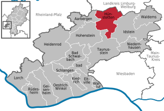
Hünstetten
- Rheingau-Taunus municipality in Germany
Hünstetten is a charming municipality located in the Rheingau-Taunus district of Hesse, Germany. It's nestled on the edge of the Taunus mountain range, making it an excellent spot for hiking enthusiasts. Here are some aspects to consider when planning a hiking trip in Hünstetten:...
- Country:

- Postal Code: 65510
- Local Dialing Code: 06438; 06128; 06126
- Coordinates: 50° 14' 58" N, 8° 11' 43" E


- GPS tracks (wikiloc): [Link]
- AboveSeaLevel: 360 м m
- Area: 50.56 sq km
- Population: 10475
- Web site: [Link]


Hohenstein
- Rheingau-Taunus municipality in Germany
Hohenstein, located in the state of Hesse, Germany, offers an array of hiking opportunities that highlight the region’s natural beauty and rich cultural heritage....
- Country:

- Postal Code: 65329
- Local Dialing Code: 06128; 06124; 06120
- Coordinates: 50° 11' 37" N, 8° 6' 1" E


- GPS tracks (wikiloc): [Link]
- AboveSeaLevel: 334 м m
- Area: 63.79 sq km
- Population: 6137
- Web site: [Link]

