Hünstetten (Hünstetten)
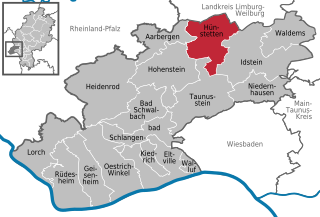
- Rheingau-Taunus municipality in Germany
Hünstetten is a charming municipality located in the Rheingau-Taunus district of Hesse, Germany. It's nestled on the edge of the Taunus mountain range, making it an excellent spot for hiking enthusiasts. Here are some aspects to consider when planning a hiking trip in Hünstetten:
Trails and Routes
-
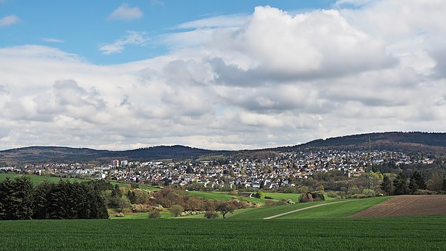
Scenic Landscapes: Hünstetten offers varied terrain, including woodlands, meadows, and hills. The trails often provide beautiful views of the surrounding countryside and nearby valleys.
-
Marked Hiking Trails: Many trails in the region are well-marked, making it easy to navigate. Popular local routes can lead you through the forests and to viewpoints that showcase the beautiful Taunus landscape.
-
Nature Reserves: The area is close to several nature reserves, providing opportunities to explore diverse flora and fauna along the hiking paths.
Recommended Hikes
-
Local Trails: You can find shorter loops perfect for family hikes or leisurely walks. These include routes that connect the villages in Hünstetten with scenic spots.
-
Long-Distance Routes: If you're up for a longer hike, consider connecting to larger trails in the Taunus region, such as the "E1 European Long-Distance Path," which traverses the area.
Accessibility
Hünstetten is accessible via public transportation from major nearby cities. This makes it a convenient getaway for a day hike.
Equipment and Preparation
- Footwear: Wear sturdy hiking boots to handle various trail conditions.
- Weather: Check the weather forecast before you head out, as conditions can change quickly in the hills.
- Supplies: Bring enough water and snacks, and consider packing a first-aid kit.
Local Attractions
After your hike, you might enjoy exploring local farms, vineyards, or cozy restaurants that reflect the region's culture and gastronomy.
Safety Considerations
Always inform someone about your hiking plans, especially if you intend to hike alone. It's good to carry a map or a GPS device, as some trails might not have mobile service.
Whether you’re a seasoned hiker or just looking for a leisurely walk in nature, Hünstetten provides a lovely backdrop for exploring the beautiful landscape of Hesse. Enjoy your hike!
- Country:

- Postal Code: 65510
- Local Dialing Code: 06438; 06128; 06126
- Coordinates: 50° 14' 58" N, 8° 11' 43" E


- GPS tracks (wikiloc): [Link]
- AboveSeaLevel: 360 м m
- Area: 50.56 sq km
- Population: 10475
- Web site: http://www.gemeinde-huenstetten.de
- Wikipedia en: wiki(en)
- Wikipedia: wiki(de)
- Wikidata storage: Wikidata: Q534887
- Wikipedia Commons Category: [Link]
- Freebase ID: [/m/02vvmjp]
- GeoNames ID: Alt: [2897302]
- VIAF ID: Alt: [248700987]
- OSM relation ID: [413391]
- GND ID: Alt: [4338885-1]
- archINFORM location ID: [12066]
- MusicBrainz area ID: [d339d27f-7c1e-4786-b0ab-5a48849ab148]
- German municipality key: 06439007
Includes regions:
Ketternschwalbach
- municipal district of Hünstetten in Rheingau-Taunus-Kreis, Germany
Ketternschwalbach is a small village in Germany, located within the scenic terrain of the Rhine Valley. This charming locale offers a variety of hiking opportunities that cater to both beginners and experienced trekkers. Here are some highlights and tips for hiking in and around Ketternschwalbach:...
- Country:

- Postal Code: 65510
- Local Dialing Code: 06438
- Coordinates: 50° 15' 51" N, 8° 9' 7" E


- GPS tracks (wikiloc): [Link]
- AboveSeaLevel: 299 м m
- Area: 5.76 sq km
Görsroth
- municipal district of Hünstetten in Rheingau-Taunus-Kreis, Germany
Görsroth, while not a widely recognized hiking destination, offers a unique experience for those looking to explore the scenic beauty of the surrounding area, particularly in regions like Germany. If you’re planning a hiking trip around Görsroth, here are some key points to consider:...
- Country:

- Postal Code: 65510
- Local Dialing Code: 06126
- Coordinates: 50° 13' 34" N, 8° 12' 48" E


- GPS tracks (wikiloc): [Link]
- AboveSeaLevel: 385 м m
- Area: 4.11 sq km

Oberlibbach
- municipal district of Hünstetten in Rheingau-Taunus-Kreis, Germany
Oberlibbach, nestled in the scenic landscape of Germany, offers a variety of hiking opportunities that cater to different skill levels. While it might not be as widely known as some other hiking destinations in Germany, it boasts beautiful natural scenery, charming trails, and a tranquil environment ideal for both nature enthusiasts and casual hikers....
- Country:

- Postal Code: 65510
- Local Dialing Code: 06128
- Coordinates: 50° 12' 25" N, 8° 11' 34" E


- GPS tracks (wikiloc): [Link]
- AboveSeaLevel: 365 м m
- Area: 3.80 sq km
Kesselbach
- municipal district of Hünstetten in Rheingau-Taunus-Kreis, Germany
Kesselbach, located in Hünstetten, Germany, is an excellent destination for hiking enthusiasts. This picturesque area combines beautiful natural landscapes with charming villages, making it a great spot for both leisurely strolls and more demanding hikes....
- Country:

- Postal Code: 65510
- Local Dialing Code: 06126
- Coordinates: 50° 13' 6" N, 8° 12' 10" E


- GPS tracks (wikiloc): [Link]
- AboveSeaLevel: 402 м m
- Area: 2.68 sq km
Limbach
- municipal district of Hünstetten in Rheingau-Taunus-Kreis, Germany
Hünstetten is a picturesque municipality located in the Rheingau-Taunus district of Hesse, Germany. The area is known for its beautiful landscapes, rolling hills, and serene nature, making it a great spot for hiking enthusiasts. Here’s what you should know about hiking in Limbach, part of Hünstetten:...
- Country:

- Postal Code: 65510
- Local Dialing Code: 06126
- Coordinates: 50° 14' 41" N, 8° 10' 31" E


- GPS tracks (wikiloc): [Link]
- AboveSeaLevel: 328 м m
- Area: 5.85 sq km
Strinz-Trinitatis
- municipal district of Hünstetten in Rheingau-Taunus-Kreis, Germany
Strinz-Trinitatis is a small village located in the state of Hesse, Germany, nestled within the scenic landscape of the Taunus mountain range. This area offers a variety of hiking opportunities, characterized by beautiful woodlands, charming villages, and panoramic views....
- Country:

- Postal Code: 65510
- Local Dialing Code: 06126
- Coordinates: 50° 14' 7" N, 8° 9' 22" E


- GPS tracks (wikiloc): [Link]
- AboveSeaLevel: 285 м m
- Area: 7.07 sq km
Wallbach
- municipal district of Hünstetten in Rheingau-Taunus-Kreis, Germany
Wallbach is a charming village located in the Taunus region of Germany, known for its beautiful landscapes and outdoor recreational opportunities, including hiking. The Taunus region is characterized by its rolling hills, wooded areas, and scenic views, making it a great destination for hikers of all skill levels....
- Country:

- Postal Code: 65510
- Local Dialing Code: 06126
- Coordinates: 50° 14' 58" N, 8° 11' 46" E


- GPS tracks (wikiloc): [Link]
- AboveSeaLevel: 320 м m
- Area: 3.86 sq km
Wallrabenstein
- municipal district of Hünstetten in Rheingau-Taunus-Kreis, Germany
Wallrabenstein is a picturesque village located within Hünstetten, in the Hessian district of Limburg-Weilburg, Germany. This area is known for its beautiful hilly landscapes, forests, and nearby nature reserves, making it an excellent destination for hiking enthusiasts of all levels....
- Country:

- Postal Code: 65510
- Local Dialing Code: 06126
- Coordinates: 50° 16' 3" N, 8° 14' 3" E


- GPS tracks (wikiloc): [Link]
- AboveSeaLevel: 250 м m
- Area: 8.02 sq km
Bechtheim
- municipal district of Hünstetten in Rheingau-Taunus-Kreis, Germany
Bechtheim, located in the municipality of Hünstetten in Germany, offers a quaint and scenic setting for hiking enthusiasts. The area is characterized by its rolling hills, beautiful landscapes, and picturesque vineyards that frame the trails. Here are some key points to consider when hiking in Bechtheim:...
- Country:

- Postal Code: 65510
- Local Dialing Code: 06438
- Coordinates: 50° 16' 25" N, 8° 11' 9" E


- GPS tracks (wikiloc): [Link]
- AboveSeaLevel: 288 м m
- Area: 3.98 sq km
Beuerbach
- municipal district of Hünstetten in Rheingau-Taunus-Kreis, Germany
Beuerbach, located in the municipality of Hünstetten in Germany, offers a charming setting for hiking enthusiasts. The region features scenic landscapes, including forests, meadows, and small hills, making it an ideal location for outdoor activities....
- Country:

- Postal Code: 65510
- Local Dialing Code: 06438
- Coordinates: 50° 16' 51" N, 8° 12' 31" E


- GPS tracks (wikiloc): [Link]
- AboveSeaLevel: 238 м m
- Area: 5.42 sq km
Shares border with regions:


Aarbergen
- Rheingau-Taunus municipality in Hesse, Germany
Aarbergen, a picturesque municipality in the Rhine Valley of Germany, offers a variety of hiking opportunities that cater to different skill levels and preferences. Nestled within the scenic landscapes of the Taunus Mountains, hikers can enjoy lush forests, rolling hills, and stunning views of the surrounding countryside....
- Country:

- Postal Code: 65326
- Local Dialing Code: 06120
- Coordinates: 50° 14' 47" N, 8° 4' 20" E


- GPS tracks (wikiloc): [Link]
- AboveSeaLevel: 230 м m
- Area: 33.94 sq km
- Population: 6082
- Web site: [Link]


Taunusstein
- town in Rheingau-Taunus-Kreis in Hesse, Germany
Taunusstein is a beautiful town located in the Taunus mountain range in Hesse, Germany. The area is known for its stunning natural landscapes, diverse flora and fauna, and numerous hiking trails suitable for various skill levels. Here are some aspects to consider if you're planning to hike in Taunusstein:...
- Country:

- Postal Code: 65232
- Local Dialing Code: 06128
- Coordinates: 50° 8' 36" N, 8° 9' 38" E


- GPS tracks (wikiloc): [Link]
- AboveSeaLevel: 381 м m
- Area: 67030000 sq km
- Population: 29746
- Web site: [Link]


Hohenstein
- Rheingau-Taunus municipality in Germany
Hohenstein, located in the state of Hesse, Germany, offers an array of hiking opportunities that highlight the region’s natural beauty and rich cultural heritage....
- Country:

- Postal Code: 65329
- Local Dialing Code: 06128; 06124; 06120
- Coordinates: 50° 11' 37" N, 8° 6' 1" E


- GPS tracks (wikiloc): [Link]
- AboveSeaLevel: 334 м m
- Area: 63.79 sq km
- Population: 6137
- Web site: [Link]

