
Abbadia San Salvatore (Abbadia San Salvatore)
.svg)
- Italian comune
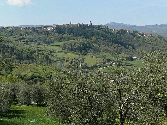
 Hiking in Abbadia San Salvatore
Abbadia San Salvatore is a picturesque town located in the province of Siena in Tuscany, Italy. It's nestled on the slopes of Mount Amiata, a dormant volcano that offers a variety of hiking opportunities through stunning landscapes, rich in natural beauty and history.
Hiking Trails
The area around Abbadia San Salvatore features numerous trails suited for different skill levels. Here are a few notable options:
-
Sentiero delle 8 Valli: This is a long-distance hiking path that connects various valleys around Mount Amiata. The trail offers diverse scenery, including forests, meadows, and panoramic views of the surrounding hills and valleys.
-
Mount Amiata Loop: There are several trails around Mount Amiata itself that vary in length and difficulty. The summit trail is popular and provides breathtaking views from the top, along with unique flora and fauna characteristic of this volcanic area.
-
Historical Trails: Some trails take you through ancient woodlands and lead to historical sites, including hermitages and ruins, providing a glimpse into the area's rich cultural history. The Hermitage of Saint Anselm is a notable stop along one of the routes.
Tips for Hiking in Abbadia San Salvatore
-
Weather: Check the weather conditions before you go, as they can change quickly, especially in the mountains. Spring and early autumn are particularly pleasant for hiking.
-
Gear: Wear sturdy hiking boots and dress in layers, as the temperatures can vary with elevation. Don’t forget to bring plenty of water, snacks, a map, and a first-aid kit.
-
Trail Markings: Follow the signs and trail markers, which are usually well-maintained. If you’re unfamiliar with the area, consider downloading a hiking app or taking a guide.
-
Local Regulations: Respect local wildlife and follow any specific guidelines for the trails, especially regarding fire safety and protected areas.
Attractions
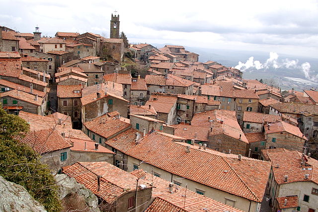
Beyond hiking, Abbadia San Salvatore itself is charming, with its medieval architecture, such as the Abbey of San Salvatore, and it offers local gastronomy showcasing the flavors of Tuscany.
Conclusion
Hiking in Abbadia San Salvatore is a great way to experience the natural beauty and cultural richness of Tuscany. Whether you seek a leisurely stroll through the woods or a challenging climb to the summit of Mount Amiata, the area has something to offer every hiking enthusiast. Enjoy your hike!
- Country:

- Postal Code: 53021
- Local Dialing Code: 0577
- Licence Plate Code: SI
- Coordinates: 42° 52' 59" N, 11° 40' 14" E


- GPS tracks (wikiloc): [Link]
- AboveSeaLevel: 822 м m
- Area: 58.99 sq km
- Population: 6325
- Web site: http://www.comune.abbadia.siena.it/
- Wikipedia en: wiki(en)
- Wikipedia: wiki(it)
- Wikidata storage: Wikidata: Q91096
- Wikipedia Commons Category: [Link]
- Freebase ID: [/m/0gm0k4]
- GeoNames ID: Alt: [6540483]
- VIAF ID: Alt: [172535936]
- OSM relation ID: [42191]
- GND ID: Alt: [4209773-3]
- Library of Congress authority ID: Alt: [n87867702]
- ISTAT ID: 052001
- Italian cadastre code: A006
Shares border with regions:

Castel del Piano
- Italian comune
Hiking in Castel del Piano
Castel del Piano is a beautiful area located in the Tuscany region of Italy, nestled within the Monte Amiata area. This region is known for its stunning landscapes, rich history, and diverse hiking opportunities. Here are some key points about hiking in Castel del Piano:...
- Country:
- Postal Code: 58033
- Local Dialing Code: 0564
- Licence Plate Code: GR
- Coordinates: 42° 53' 27" N, 11° 32' 22" E
- GPS tracks (wikiloc): [Link]
- AboveSeaLevel: 637 м m
- Area: 67.77 sq km
- Population: 4810
- Web site: [Link]


Santa Fiora
- Italian comune
Hiking in Santa Fiora
Santa Fiora is a charming village located in the Tuscan region of Italy, known for its beautiful natural surroundings, rich history, and excellent hiking opportunities. Nestled on the slopes of Mount Amiata, it offers stunning views and a variety of trails suitable for hikers of different skill levels. Here are some highlights of hiking in Santa Fiora:...
- Country:
- Postal Code: 58037
- Local Dialing Code: 0564
- Licence Plate Code: GR
- Coordinates: 42° 49' 55" N, 11° 35' 7" E
- GPS tracks (wikiloc): [Link]
- AboveSeaLevel: 687 м m
- Area: 63.45 sq km
- Population: 2563
- Web site: [Link]


Seggiano
- Italian comune
Hiking in Seggiano
Seggiano is a charming village located in the Tuscany region of Italy, situated on the slopes of Mount Amiata. The area is known for its beautiful landscapes, traditional Tuscan architecture, and rich natural resources, making it an excellent destination for hiking enthusiasts....
- Country:
- Postal Code: 58038
- Local Dialing Code: 0564
- Licence Plate Code: GR
- Coordinates: 42° 55' 45" N, 11° 33' 30" E
- GPS tracks (wikiloc): [Link]
- AboveSeaLevel: 491 м m
- Area: 49.43 sq km
- Population: 958
- Web site: [Link]


Castiglione d'Orcia
- Italian comune
Hiking in Castiglione d'Orcia
Castiglione d'Orcia is a picturesque village located in the Val d'Orcia region of Tuscany, Italy. Surrounded by stunning landscapes, rolling hills, and charming vineyards, it offers a variety of hiking opportunities for those wanting to explore the natural beauty and cultural heritage of the area....
- Country:
- Postal Code: 53023
- Local Dialing Code: 0577
- Licence Plate Code: SI
- Coordinates: 43° 1' 0" N, 11° 37' 0" E
- GPS tracks (wikiloc): [Link]
- AboveSeaLevel: 540 м m
- Area: 141.66 sq km
- Population: 2294
- Web site: [Link]

Piancastagnaio
- Italian comune
Hiking in Piancastagnaio
Piancastagnaio is a charming town located in the province of Siena, Tuscany, Italy. It's situated in the Monte Amiata area, which offers a wealth of natural beauty and diverse hiking opportunities....
- Country:
- Postal Code: 53025
- Local Dialing Code: 0577
- Licence Plate Code: SI
- Coordinates: 42° 51' 0" N, 11° 41' 0" E
- GPS tracks (wikiloc): [Link]
- AboveSeaLevel: 772 м m
- Area: 69.63 sq km
- Population: 4181
- Web site: [Link]


Radicofani
- Italian comune
Hiking in Radicofani
Radicofani is a charming village in Tuscany, Italy, known for its stunning landscapes, historical significance, and opportunities for hiking. Located near the border of Lazio, it sits atop a hill, offering sweeping views of the surrounding valleys and the nearby Orcia Valley, which is a UNESCO World Heritage site....
- Country:
- Postal Code: 53040
- Local Dialing Code: 0578
- Licence Plate Code: SI
- Coordinates: 42° 54' 0" N, 11° 46' 0" E
- GPS tracks (wikiloc): [Link]
- AboveSeaLevel: 780 м m
- Area: 118.1 sq km
- Population: 1073
- Web site: [Link]


San Casciano dei Bagni
- Italian comune
Hiking in San Casciano dei Bagni
San Casciano dei Bagni, located in the stunning region of Tuscany, Italy, is not only known for its relaxing thermal baths but also for its beautiful hiking opportunities. The surrounding landscape is characterized by rolling hills, charming vineyards, olive groves, and the picturesque Val d'Orcia. Here’s a guide to hiking in this picturesque area:...
- Country:
- Postal Code: 53040
- Local Dialing Code: 0578
- Licence Plate Code: SI
- Coordinates: 42° 52' 0" N, 11° 53' 0" E
- GPS tracks (wikiloc): [Link]
- AboveSeaLevel: 582 м m
- Area: 92.14 sq km
- Population: 1601
- Web site: [Link]