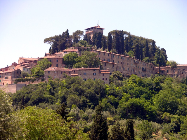
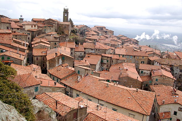
San Casciano dei Bagni (San Casciano dei Bagni)
- Italian comune
 Hiking in San Casciano dei Bagni
San Casciano dei Bagni, located in the stunning region of Tuscany, Italy, is not only known for its relaxing thermal baths but also for its beautiful hiking opportunities. The surrounding landscape is characterized by rolling hills, charming vineyards, olive groves, and the picturesque Val d'Orcia. Here’s a guide to hiking in this picturesque area:
Popular Hiking Trails
-
Path of the Thermal Springs: This trail takes you through the scenic countryside, allowing you to admire the natural hot springs. The path is relatively easy and offers stunning views of the surrounding hills.
-
Sentiero della Bonifica: A longer hike that connects several towns in the area, this route provides a mix of farmland and natural beauty, with well-marked paths. It’s a great way to engage with the local environment and perhaps stop at quaint villages.
-
Monti Cetona: For those looking for a more challenging hike, the trails in the nearby Monti Cetona offer rugged terrain and breathtaking panoramas. The climb up to the summit provides a rewarding views of the surrounding landscape.
Tips for Hiking in San Casciano dei Bagni
-
Best Time to Visit: Spring and early fall are ideal times for hiking. The weather is mild, and the countryside is bursting with flowers or autumn colors.
-
Stay Hydrated: Always carry plenty of water, especially in warmer months.
-
Footwear: Wear sturdy hiking boots with good grip, as some trails can be rocky or uneven.
-
Trail Map: It’s advisable to have a detailed hiking map or a GPS device since some trails may not be well marked.
-
Respect Nature: Follow Leave No Trace principles, and be considerate of wildlife and the environment.
Other Activities
In addition to hiking, you can enjoy the thermal baths for relaxation, explore local wineries, or visit historical sites nearby, such as ancient monasteries and castles.
Whether you’re looking for a leisurely stroll through olive groves or a more strenuous trek up a mountain, San Casciano dei Bagni offers something for every hiker. Enjoy your adventure in this beautiful part of Tuscany!
- Country:

- Postal Code: 53040
- Local Dialing Code: 0578
- Licence Plate Code: SI
- Coordinates: 42° 52' 0" N, 11° 53' 0" E


- GPS tracks (wikiloc): [Link]
- AboveSeaLevel: 582 м m
- Area: 92.14 sq km
- Population: 1601
- Web site: http://www.comune.sancascianodeibagni.siena.it/
- Wikipedia en: wiki(en)
- Wikipedia: wiki(it)
- Wikidata storage: Wikidata: Q91403
- Wikipedia Commons Category: [Link]
- Freebase ID: [/m/0gm10g]
- GeoNames ID: Alt: [6538601]
- VIAF ID: Alt: [141094650]
- OSM relation ID: [42185]
- GND ID: Alt: [4838790-3]
- TGN ID: [7023893]
- UN/LOCODE: [ITACB]
- Digital Atlas of the Roman Empire ID: [33614]
- ISTAT ID: 052027
- Italian cadastre code: H790
Shares border with regions:


Acquapendente
- Italian comune
Acquapendente is a charming town located in the province of Viterbo in the Lazio region of Italy, surrounded by beautiful countryside and natural landscapes. The area offers various hiking opportunities, which showcase the stunning scenery and rich historical background of the region....
- Country:

- Postal Code: 01021
- Local Dialing Code: 0763
- Licence Plate Code: VT
- Coordinates: 42° 44' 41" N, 11° 51' 54" E


- GPS tracks (wikiloc): [Link]
- AboveSeaLevel: 420 м m
- Area: 131.61 sq km
- Population: 5439
- Web site: [Link]


Proceno
- Italian comune
Proceno, a charming village located in the province of Viterbo in Italy, offers some delightful hiking opportunities amidst scenic countryside, rolling hills, and rich historical landscapes. Here are some highlights regarding hiking in and around Proceno:...
- Country:

- Postal Code: 01020
- Local Dialing Code: 0763
- Licence Plate Code: VT
- Coordinates: 42° 45' 29" N, 11° 49' 50" E


- GPS tracks (wikiloc): [Link]
- AboveSeaLevel: 418 м m
- Area: 42.02 sq km
- Population: 602
- Web site: [Link]


Città della Pieve
- Italian comune
Città della Pieve, located in the Umbria region of Italy, is a charming hilltop town known for its stunning landscapes, historic architecture, and rich cultural heritage. Hiking in this area offers a mix of scenic views, rolling hills, vineyards, and olive groves, making it an appealing destination for outdoor enthusiasts....
- Country:

- Postal Code: 06062
- Local Dialing Code: 0578
- Licence Plate Code: PG
- Coordinates: 42° 57' 14" N, 12° 0' 28" E


- GPS tracks (wikiloc): [Link]
- AboveSeaLevel: 508 м m
- Area: 110.94 sq km
- Population: 7686
- Web site: [Link]


Allerona
- town in the region Umbria, in Italy
Allerona is a charming town located in the province of Terni, in the Umbria region of Italy. It is set in a beautiful natural landscape, characterized by rolling hills, vineyards, olive groves, and lush forests, making it a fantastic destination for hikers and nature lovers....
- Country:

- Postal Code: 05011
- Local Dialing Code: 0763
- Licence Plate Code: TR
- Coordinates: 42° 49' 0" N, 11° 58' 0" E


- GPS tracks (wikiloc): [Link]
- AboveSeaLevel: 472 м m
- Area: 82.61 sq km
- Population: 1769
- Web site: [Link]


Fabro
- town in the region Umbria, in Italy
Fabro is a charming medieval town located in the Umbria region of Italy. While it may not be as widely recognized for hiking as some larger national parks, it offers access to beautiful landscapes, picturesque trails, and a rich cultural backdrop that can make for a unique hiking experience....
- Country:

- Postal Code: 05015
- Local Dialing Code: 0763
- Licence Plate Code: TR
- Coordinates: 42° 52' 0" N, 12° 1' 0" E


- GPS tracks (wikiloc): [Link]
- AboveSeaLevel: 364 м m
- Area: 34.55 sq km
- Population: 2828
- Web site: [Link]


Abbadia San Salvatore
- Italian comune
 Hiking in Abbadia San Salvatore
Abbadia San Salvatore is a picturesque town located in the province of Siena in Tuscany, Italy. It's nestled on the slopes of Mount Amiata, a dormant volcano that offers a variety of hiking opportunities through stunning landscapes, rich in natural beauty and history....
- Country:

- Postal Code: 53021
- Local Dialing Code: 0577
- Licence Plate Code: SI
- Coordinates: 42° 52' 59" N, 11° 40' 14" E


- GPS tracks (wikiloc): [Link]
- AboveSeaLevel: 822 м m
- Area: 58.99 sq km
- Population: 6325
- Web site: [Link]


Cetona
- Italian comune
Cetona is a beautiful town located in the Tuscany region of Italy, known for its stunning landscapes and rich history. The area surrounding Cetona offers several hiking opportunities that cater to different skill levels, making it a great destination for outdoor enthusiasts....
- Country:

- Postal Code: 53040
- Local Dialing Code: 0578
- Licence Plate Code: SI
- Coordinates: 42° 58' 0" N, 11° 54' 0" E


- GPS tracks (wikiloc): [Link]
- AboveSeaLevel: 350 м m
- Area: 53.57 sq km
- Population: 2678
- Web site: [Link]


Piancastagnaio
- Italian comune
Piancastagnaio is a charming town located in the province of Siena, Tuscany, Italy. It's situated in the Monte Amiata area, which offers a wealth of natural beauty and diverse hiking opportunities....
- Country:

- Postal Code: 53025
- Local Dialing Code: 0577
- Licence Plate Code: SI
- Coordinates: 42° 51' 0" N, 11° 41' 0" E


- GPS tracks (wikiloc): [Link]
- AboveSeaLevel: 772 м m
- Area: 69.63 sq km
- Population: 4181
- Web site: [Link]

Radicofani
- Italian comune
Radicofani is a charming village in Tuscany, Italy, known for its stunning landscapes, historical significance, and opportunities for hiking. Located near the border of Lazio, it sits atop a hill, offering sweeping views of the surrounding valleys and the nearby Orcia Valley, which is a UNESCO World Heritage site....
- Country:

- Postal Code: 53040
- Local Dialing Code: 0578
- Licence Plate Code: SI
- Coordinates: 42° 54' 0" N, 11° 46' 0" E


- GPS tracks (wikiloc): [Link]
- AboveSeaLevel: 780 м m
- Area: 118.1 sq km
- Population: 1073
- Web site: [Link]


Sarteano
- Italian comune
Sarteano is a charming town located in the Valdichiana area of Tuscany, Italy. Known for its stunning landscapes, medieval architecture, and rich history, Sarteano is an excellent base for hiking enthusiasts looking to explore the picturesque Tuscan countryside....
- Country:

- Postal Code: 53047
- Local Dialing Code: 0578
- Licence Plate Code: SI
- Coordinates: 42° 59' 0" N, 11° 52' 0" E


- GPS tracks (wikiloc): [Link]
- AboveSeaLevel: 525 м m
- Area: 84.81 sq km
- Population: 4705
- Web site: [Link]
