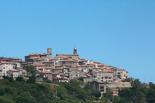
Piancastagnaio (Piancastagnaio)
.svg)
- Italian comune
 Hiking in Piancastagnaio
Piancastagnaio is a charming town located in the province of Siena, Tuscany, Italy. It's situated in the Monte Amiata area, which offers a wealth of natural beauty and diverse hiking opportunities.
Hiking Trails
-
Monte Amiata: The most prominent feature near Piancastagnaio is Monte Amiata itself, an extinct volcano. There are several trails that lead up to the summit, where hikers can enjoy stunning panoramic views of the surrounding landscapes, including the Val d'Orcia and the Maremma.
-
Cypress and Chestnut Forests: The area around Piancastagnaio is rich in biodiversity. Trails wind through cypress and chestnut forests, providing a peaceful hiking experience while also allowing you to enjoy the local flora and fauna.
-
Villages and Historical Sites: Many hiking trails connect Piancastagnaio to nearby villages and historical sites. You might encounter old churches, ancient ruins, and picturesque rural landscapes along the way.
Difficulty Levels
The hiking trails in the Piancastagnaio area vary in difficulty from easy strolls through scenic woodlands to more challenging ascents. It's suitable for families, casual walkers, and more experienced hikers looking for adventure.
Best Time to Hike
The best time for hiking in Piancastagnaio is during the spring (April to June) and fall (September to October) when the weather is mild, and the natural scenery is especially vibrant. Summer can be hot, and winter may bring snow at higher elevations, so be prepared accordingly.
Practical Considerations
- Equipment: Make sure to wear appropriate hiking shoes and bring layers, as temperatures can vary.
- Maps: It's advisable to carry a map or a GPS device, as some trails may not be well-marked.
- Guided Tours: For those interested in learning more about the natural history and culture of the area, consider joining a guided hiking tour.
Local Attractions
If you have time, explore the town of Piancastagnaio itself. It has a rich history, and its medieval quarter is worth wandering. Don't forget to try local Tuscan cuisine in the area’s trattorias.
In summary, hiking in Piancastagnaio offers an excellent opportunity to experience the natural beauty and cultural heritage of Tuscany, making it a fantastic destination for outdoor enthusiasts.
- Country:

- Postal Code: 53025
- Local Dialing Code: 0577
- Licence Plate Code: SI
- Coordinates: 42° 51' 0" N, 11° 41' 0" E


- GPS tracks (wikiloc): [Link]
- AboveSeaLevel: 772 м m
- Area: 69.63 sq km
- Population: 4181
- Web site: http://www.comune.piancastagnaio.siena.it
- Wikipedia en: wiki(en)
- Wikipedia: wiki(it)
- Wikidata storage: Wikidata: Q91292
- Wikipedia Commons Gallery: [Link]
- Wikipedia Commons Category: [Link]
- Freebase ID: [/m/0gm0wh]
- GeoNames ID: Alt: [6536852]
- VIAF ID: Alt: [132958244]
- OSM relation ID: [42171]
- GND ID: Alt: [4408862-0]
- UN/LOCODE: [ITPAH]
- ISTAT ID: 052020
- Italian cadastre code: G547
Shares border with regions:

Castell'Azzara
- Italian comune
Hiking in Castell'Azzara
Castell'Azzara is a charming village located in the province of Grosseto, Tuscany, Italy. It's known for its scenic landscapes and rich natural beauty, making it a great destination for hiking enthusiasts. Here are some highlights and tips for hiking in the area:...
- Country:
- Postal Code: 58034
- Local Dialing Code: 0564
- Licence Plate Code: GR
- Coordinates: 42° 46' 21" N, 11° 41' 55" E
- GPS tracks (wikiloc): [Link]
- AboveSeaLevel: 815 м m
- Area: 64.23 sq km
- Population: 1414
- Web site: [Link]


Proceno
- Italian comune
Hiking in Proceno
Proceno, a charming village located in the province of Viterbo in Italy, offers some delightful hiking opportunities amidst scenic countryside, rolling hills, and rich historical landscapes. Here are some highlights regarding hiking in and around Proceno:...
- Country:
- Postal Code: 01020
- Local Dialing Code: 0763
- Licence Plate Code: VT
- Coordinates: 42° 45' 29" N, 11° 49' 50" E
- GPS tracks (wikiloc): [Link]
- AboveSeaLevel: 418 м m
- Area: 42.02 sq km
- Population: 602
- Web site: [Link]


Santa Fiora
- Italian comune
Hiking in Santa Fiora
Santa Fiora is a charming village located in the Tuscan region of Italy, known for its beautiful natural surroundings, rich history, and excellent hiking opportunities. Nestled on the slopes of Mount Amiata, it offers stunning views and a variety of trails suitable for hikers of different skill levels. Here are some highlights of hiking in Santa Fiora:...
- Country:
- Postal Code: 58037
- Local Dialing Code: 0564
- Licence Plate Code: GR
- Coordinates: 42° 49' 55" N, 11° 35' 7" E
- GPS tracks (wikiloc): [Link]
- AboveSeaLevel: 687 м m
- Area: 63.45 sq km
- Population: 2563
- Web site: [Link]


Abbadia San Salvatore
- Italian comune
Hiking in Abbadia San Salvatore
Abbadia San Salvatore is a picturesque town located in the province of Siena in Tuscany, Italy. It's nestled on the slopes of Mount Amiata, a dormant volcano that offers a variety of hiking opportunities through stunning landscapes, rich in natural beauty and history....
- Country:
- Postal Code: 53021
- Local Dialing Code: 0577
- Licence Plate Code: SI
- Coordinates: 42° 52' 59" N, 11° 40' 14" E
- GPS tracks (wikiloc): [Link]
- AboveSeaLevel: 822 м m
- Area: 58.99 sq km
- Population: 6325
- Web site: [Link]


San Casciano dei Bagni
- Italian comune
Hiking in San Casciano dei Bagni
San Casciano dei Bagni, located in the stunning region of Tuscany, Italy, is not only known for its relaxing thermal baths but also for its beautiful hiking opportunities. The surrounding landscape is characterized by rolling hills, charming vineyards, olive groves, and the picturesque Val d'Orcia. Here’s a guide to hiking in this picturesque area:...
- Country:
- Postal Code: 53040
- Local Dialing Code: 0578
- Licence Plate Code: SI
- Coordinates: 42° 52' 0" N, 11° 53' 0" E
- GPS tracks (wikiloc): [Link]
- AboveSeaLevel: 582 м m
- Area: 92.14 sq km
- Population: 1601
- Web site: [Link]