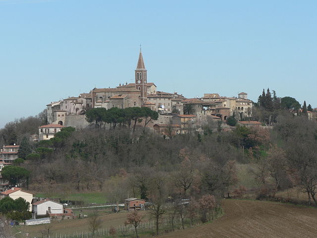
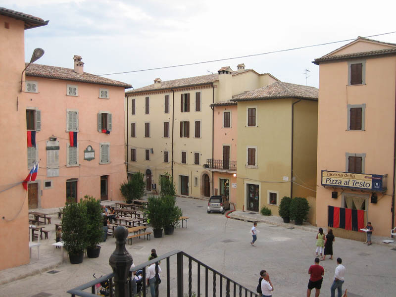
Acquasparta (Acquasparta)
.svg)
- town in the region Umbria, in Italy
 Hiking in Acquasparta
Acquasparta is a charming town located in the Umbria region of Italy, known for its rich history and beautiful landscapes. It offers a variety of hiking opportunities that allow you to explore the scenic Umbrian countryside, with its rolling hills, ancient ruins, and lush greenery.
Hiking Trails
-
CAI Trails: The Italian Alpine Club (CAI) has marked various trails in the Acquasparta area, catering to different skill levels. These trails often lead through woods, vineyards, and olive groves, giving hikers a chance to experience the local flora and fauna.
-
Natural Reserve of Monte Casciarello: This area offers more challenging hiking trails leading to breathtaking views of the surrounding valleys. You may encounter local wildlife and enjoy a variety of plant species along the paths.
-
Waterfall Trails: The surrounding areas offer trails that lead to beautiful waterfalls, making for great spots to rest and enjoy a picnic.
-
Historic Trails: Some trails can take you to nearby historic sites, such as the ruins of ancient Roman structures or medieval towns, adding a cultural element to your hike.
Recommended Tips
-
Best Time to Hike: The ideal time for hiking in Acquasparta is during the spring (April to June) and fall (September to October) when temperatures are mild, and the landscape is particularly beautiful.
-
Gear: Ensure you have appropriate hiking shoes, enough water, snacks, and a map or GPS for navigation.
-
Local Guides: Consider hiring a local guide for a more enriching experience. They can offer insights into the history and biodiversity of the area.
-
Respect Nature: Follow Leave No Trace principles to keep the trails clean and preserve the natural beauty for others.
Additional Activities
While hiking is a highlight, Acquasparta also offers opportunities for cultural visits, including local wineries, historic sites, and traditional Umbrian cuisine. Make sure to explore the local culture and indulge in some of the regional delicacies after your hike!
Enjoy the beauty of Acquasparta and the surrounding countryside while hiking!
- Country:

- Postal Code: 05021
- Local Dialing Code: 0744
- Licence Plate Code: TR
- Coordinates: 42° 41' 0" N, 12° 33' 0" E


- GPS tracks (wikiloc): [Link]
- AboveSeaLevel: 320 м m
- Area: 81.61 sq km
- Population: 4676
- Web site: http://www.comune.acquasparta.tr.it
- Wikipedia en: wiki(en)
- Wikipedia: wiki(it)
- Wikidata storage: Wikidata: Q6029
- Wikipedia Commons Category: [Link]
- Freebase ID: [/m/09j02_]
- GeoNames ID: Alt: [6540494]
- VIAF ID: Alt: [236055169]
- OSM relation ID: [42132]
- archINFORM location ID: [7674]
- MusicBrainz area ID: [cc61a0e0-a508-4ee3-a818-55ecb376dd1b]
- TGN ID: [7058042]
- UN/LOCODE: [ITACS]
- Facebook Places ID: [106231952741855]
- ISTAT ID: 055001
- Italian cadastre code: A045
Shares border with regions:
Montecastrilli
- town in the region Umbria, Italy
Hiking in Montecastrilli
Montecastrilli, located in the Umbria region of Italy, is surrounded by beautiful landscapes that are perfect for hiking enthusiasts. The area offers a mix of natural beauty, historical sites, and charming rural scenery. Here are some highlights for hiking in Montecastrilli:...
- Country:
- Postal Code: 05026
- Local Dialing Code: 0744
- Licence Plate Code: TR
- Coordinates: 42° 39' 0" N, 12° 29' 0" E
- GPS tracks (wikiloc): [Link]
- AboveSeaLevel: 391 м m
- Area: 62.43 sq km
- Population: 5037
- Web site: [Link]

Massa Martana
- Italian comune
Hiking in Massa Martana
Massa Martana, located in the province of Terni in Italy's Umbria region, is a beautiful destination for hiking enthusiasts. The area is characterized by its lush landscapes, rolling hills, and rich historical significance, which makes it an excellent spot for outdoor adventures....
- Country:
- Postal Code: 06056
- Local Dialing Code: 075
- Licence Plate Code: PG
- Coordinates: 42° 47' 0" N, 12° 31' 0" E
- GPS tracks (wikiloc): [Link]
- AboveSeaLevel: 351 м m
- Area: 78.41 sq km
- Population: 3742
- Web site: [Link]


Spoleto
- Italian comune
Hiking in Spoleto
Spoleto, located in the heart of Umbria, Italy, is a fantastic destination for hikers, offering a blend of stunning landscapes, historical significance, and a variety of trails catering to different skill levels. Here’s an overview of what you can expect when hiking in this enchanting region:...
- Country:
- Postal Code: 06049
- Local Dialing Code: 0743
- Licence Plate Code: PG
- Coordinates: 42° 44' 0" N, 12° 44' 0" E
- GPS tracks (wikiloc): [Link]
- AboveSeaLevel: 396 м m
- Area: 348.14 sq km
- Population: 38035
- Web site: [Link]


Todi
- Italian comune
Hiking in Todi
Todi, a picturesque medieval town in the Umbria region of Italy, offers a range of hiking opportunities that allow you to explore its stunning natural landscapes and rich cultural heritage. Here are some key points to consider if you're planning to hike in Todi:...
- Country:
- Postal Code: 06059
- Local Dialing Code: 075
- Licence Plate Code: PG
- Coordinates: 42° 47' 0" N, 12° 25' 0" E
- GPS tracks (wikiloc): [Link]
- AboveSeaLevel: 410 м m
- Area: 222.86 sq km
- Population: 16606
- Web site: [Link]


Avigliano Umbro
- town in the region Umbria, in Italy
Hiking in Avigliano Umbro
Avigliano Umbro, located in the Umbria region of Italy, offers a picturesque landscape that is ideal for hiking enthusiasts. Nestled in the hills and surrounded by lush woods and valleys, this area provides a perfect blend of natural beauty, historical sites, and tranquility....
- Country:
- Postal Code: 05020
- Local Dialing Code: 0744
- Licence Plate Code: TR
- Coordinates: 42° 39' 0" N, 12° 26' 0" E
- GPS tracks (wikiloc): [Link]
- AboveSeaLevel: 441 м m
- Area: 51.34 sq km
- Population: 2509
- Web site: [Link]


Terni
- city in the region Umbria, in Italy
Hiking in Terni
Terni, located in the Umbria region of Italy, offers a variety of hiking opportunities that are perfect for outdoor enthusiasts. The area is known for its stunning natural landscapes, including waterfalls, rivers, and rolling hills. Here are some key highlights about hiking in and around Terni:...
- Country:
- Postal Code: 05100
- Local Dialing Code: 0744
- Licence Plate Code: TR
- Coordinates: 42° 34' 0" N, 12° 39' 0" E
- GPS tracks (wikiloc): [Link]
- AboveSeaLevel: 130 м m
- Area: 211.90 sq km
- Population: 111189
- Web site: [Link]