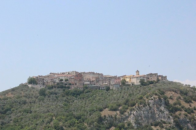
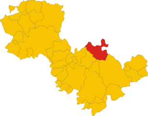
Spoleto (Spoleto)
.svg)
- Italian comune
 Hiking in Spoleto
Spoleto, located in the heart of Umbria, Italy, is a fantastic destination for hikers, offering a blend of stunning landscapes, historical significance, and a variety of trails catering to different skill levels. Here’s an overview of what you can expect when hiking in this enchanting region:
Trails and Routes
-
Via di Francesco: This trail follows the footsteps of St. Francis of Assisi and connects different towns in Umbria. The sections around Spoleto provide beautiful views and serene landscapes.
-
Parks and Natural Areas: The Monti Martani Regional Park, located nearby, has numerous trails that showcase the region's flora, fauna, and beautiful vistas.
-
Cascata delle Marmore: While primarily known for its stunning waterfalls, the area around Cascata delle Marmore offers numerous walking paths and hiking routes that provide different perspectives of the falls and the surrounding nature.
-
Spoleto to Rocca Albornoziana: A shorter hike that takes you up to the historical fortress, offering panoramic views of the surrounding countryside and the town of Spoleto itself.
Difficulty Levels
Hiking trails around Spoleto cater to various skill levels:
- Easy: Gentle paths suitable for families and beginners.
- Moderate: Trails with some elevation gain and more rugged terrain.
- Challenging: Steeper and longer hikes for experienced hikers looking for a workout and rewarding views.
Highlights
- Scenic Views: Many trails offer breathtaking views of the Umbrian hills, valleys, and the historic architecture of Spoleto.
- Cultural Sites: Hiking in the area often leads to ancient churches, castles, and ruins, enriching your outdoor experience with historical context.
- Flora and Fauna: The region is rich in biodiversity, making it a great spot for nature lovers and wildlife enthusiasts.
Best Time to Hike
The best times for hiking in Spoleto are spring (April to June) and fall (September to October) when temperatures are mild, and the landscapes are particularly vibrant. Summer can be hot, while winter may bring snow, especially at higher elevations.
Preparation Tips
- Footwear: Wear sturdy hiking boots for comfort and support.
- Navigation: Bring a map or GPS device as some trails may not be well-marked.
- Supplies: Carry enough water, snacks, and sun protection.
- Local Knowledge: Consider joining a guided hike to learn more about the environment and history of the area.
Hiking in Spoleto offers a unique combination of natural beauty and cultural heritage, making it a rewarding experience for outdoor enthusiasts. Whether you're trekking through wooded paths or exploring ancient ruins, there's plenty to discover in this picturesque part of Italy.
- Country:

- Postal Code: 06049
- Local Dialing Code: 0743
- Licence Plate Code: PG
- Coordinates: 42° 44' 0" N, 12° 44' 0" E


- GPS tracks (wikiloc): [Link]
- AboveSeaLevel: 396 м m
- Area: 348.14 sq km
- Population: 38035
- Web site: http://www.comunespoleto.gov.it/
- Wikipedia en: wiki(en)
- Wikipedia: wiki(it)
- Wikidata storage: Wikidata: Q20571
- Wikipedia Commons Gallery: [Link]
- Wikipedia Commons Category: [Link]
- Freebase ID: [/m/01pr7d]
- GeoNames ID: Alt: [6541116]
- BnF ID: [12245663c]
- VIAF ID: Alt: [139544297]
- OSM relation ID: [42105]
- GND ID: Alt: [4105495-7]
- archINFORM location ID: [1062]
- PACTOLS thesaurus ID: [pcrt2N2EvbrYD8]
- MusicBrainz area ID: [f6b4c8b7-cefb-420f-bc7a-df91ac0613cb]
- UN/LOCODE: [ITSLT]
- Encyclopædia Universalis ID: [spolete]
- EMLO location ID: [0c6e8ac7-79b2-4aba-936a-7b456449b9f9]
- Facebook Places ID: [115287148484571]
- Great Russian Encyclopedia Online ID: [4248051]
- Digital Atlas of the Roman Empire ID: [42237]
- DMOZ ID: Alt: [Regional/Europe/Italy/Umbria/Localities/Spoleto/]
- Pleiades ID: [413320]
- Treccani ID: [Spoleto]
- ISTAT ID: 054051
- Italian cadastre code: I921
- US National Archives Identifier: 10044623
Shares border with regions:


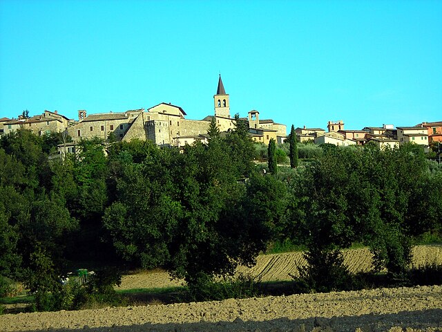
Ferentillo
- town in the region Umbria, in Italy
Hiking in Ferentillo
Ferentillo is a charming village located in the province of Terni, in the Umbria region of Italy. Nestled in the Valnerina valley, it is surrounded by stunning natural landscapes, making it an ideal destination for hiking enthusiasts. Here are some insights about hiking in and around Ferentillo:...
- Country:
- Postal Code: 05034
- Local Dialing Code: 0744
- Licence Plate Code: TR
- Coordinates: 42° 37' 17" N, 12° 47' 25" E
- GPS tracks (wikiloc): [Link]
- AboveSeaLevel: 260 м m
- Area: 69.59 sq km
- Population: 1873
- Web site: [Link]

Montefranco
- town in the region Umbria, in Italy
Hiking in Montefranco
Montefranco, located in the beautiful Region of Umbria in Italy, is an excellent destination for hiking enthusiasts. Nestled in the Valnerina valley, this area offers stunning landscapes, rich biodiversity, and a variety of trails suitable for different skill levels....
- Country:
- Postal Code: 05030
- Local Dialing Code: 0744
- Licence Plate Code: TR
- Coordinates: 42° 36' 0" N, 12° 46' 0" E
- GPS tracks (wikiloc): [Link]
- AboveSeaLevel: 375 м m
- Area: 10.09 sq km
- Population: 1304
- Web site: [Link]


Campello sul Clitunno
- Italian comune
Hiking in Campello sul Clitunno
Campello sul Clitunno is a picturesque village located in the province of Perugia, in the Umbria region of Italy. Known for its stunning landscapes and rich natural environment, it offers several opportunities for hiking and exploring the surrounding areas....
- Country:
- Postal Code: 06042
- Local Dialing Code: 0743
- Licence Plate Code: PG
- Coordinates: 42° 49' 0" N, 12° 46' 0" E
- GPS tracks (wikiloc): [Link]
- AboveSeaLevel: 290 м m
- Area: 49.76 sq km
- Population: 2375
- Web site: [Link]

Castel Ritaldi
- Italian comune
Hiking in Castel Ritaldi
Castel Ritaldi, located in the Umbria region of Italy, offers a charming backdrop for hiking enthusiasts. This small town is surrounded by beautiful rolling hills, vineyards, and olive groves, making it an ideal location to explore the natural beauty of the area....
- Country:
- Postal Code: 06044
- Local Dialing Code: 0743
- Licence Plate Code: PG
- Coordinates: 42° 49' 24" N, 12° 40' 20" E
- GPS tracks (wikiloc): [Link]
- AboveSeaLevel: 297 м m
- Area: 22.44 sq km
- Population: 3245
- Web site: [Link]

Giano dell'Umbria
- Italian comune
Hiking in Giano dell'Umbria
Giano dell'Umbria, located in the heart of Umbria, Italy, is a picturesque destination that offers a unique blend of hiking opportunities and breathtaking landscapes. Here’s an overview of what you can expect when hiking in this charming area:...
- Country:
- Postal Code: 06030
- Local Dialing Code: 0742
- Licence Plate Code: PG
- Coordinates: 42° 50' 0" N, 12° 35' 0" E
- GPS tracks (wikiloc): [Link]
- AboveSeaLevel: 547 м m
- Area: 44.48 sq km
- Population: 3893
- Web site: [Link]

Massa Martana
- Italian comune
Hiking in Massa Martana
Massa Martana, located in the province of Terni in Italy's Umbria region, is a beautiful destination for hiking enthusiasts. The area is characterized by its lush landscapes, rolling hills, and rich historical significance, which makes it an excellent spot for outdoor adventures....
- Country:
- Postal Code: 06056
- Local Dialing Code: 075
- Licence Plate Code: PG
- Coordinates: 42° 47' 0" N, 12° 31' 0" E
- GPS tracks (wikiloc): [Link]
- AboveSeaLevel: 351 м m
- Area: 78.41 sq km
- Population: 3742
- Web site: [Link]


Sant'Anatolia di Narco
- Italian comune
Hiking in Sant'Anatolia di Narco
Sant'Anatolia di Narco is a charming village located in the Umbria region of Italy, surrounded by scenic landscapes, rolling hills, and lush forests, making it a great destination for hiking enthusiasts. The area offers a mix of trails that cater to different skill levels, so both beginners and experienced hikers can enjoy the natural beauty of the region....
- Country:
- Postal Code: 06040
- Local Dialing Code: 0743
- Licence Plate Code: PG
- Coordinates: 42° 44' 0" N, 12° 50' 0" E
- GPS tracks (wikiloc): [Link]
- AboveSeaLevel: 328 м m
- Area: 46.55 sq km
- Population: 557
- Web site: [Link]
Scheggino
- Italian comune
Hiking in Scheggino
Scheggino is a charming village located in the heart of Umbria, Italy, known for its picturesque landscapes, rich history, and excellent hiking opportunities. The area is characterized by rolling hills, lush valleys, and stunning views of the surrounding mountains, making it a great destination for outdoor enthusiasts....
- Country:
- Postal Code: 06040
- Local Dialing Code: 0743
- Licence Plate Code: PG
- Coordinates: 42° 43' 0" N, 12° 50' 0" E
- GPS tracks (wikiloc): [Link]
- AboveSeaLevel: 281 м m
- Area: 35.85 sq km
- Population: 452
- Web site: [Link]


Trevi
- Italian comune
Hiking in Trevi
Trevi, located in the Umbria region of Italy, is a charming town known for its picturesque landscapes, olive groves, and scenic hills. It offers several excellent hiking opportunities, suitable for different skill levels. Here are some highlights and suggestions for hiking in and around Trevi:...
- Country:
- Postal Code: 06039
- Local Dialing Code: 0742
- Licence Plate Code: PG
- Coordinates: 42° 53' 36" N, 12° 45' 42" E
- GPS tracks (wikiloc): [Link]
- AboveSeaLevel: 412 м m
- Area: 71.19 sq km
- Population: 8363
- Web site: [Link]


Vallo di Nera
- Italian comune
Hiking in Vallo di Nera
Vallo di Nera is a beautiful village in the Umbria region of Italy, surrounded by stunning natural landscapes that make it an excellent destination for hiking enthusiasts. Here's an overview of what to expect when hiking in and around Vallo di Nera:...
- Country:
- Postal Code: 06040
- Local Dialing Code: 0743
- Licence Plate Code: PG
- Coordinates: 42° 45' 19" N, 12° 51' 52" E
- GPS tracks (wikiloc): [Link]
- AboveSeaLevel: 467 м m
- Area: 36.22 sq km
- Population: 360
- Web site: [Link]

Acquasparta
- town in the region Umbria, in Italy
Hiking in Acquasparta
Acquasparta is a charming town located in the Umbria region of Italy, known for its rich history and beautiful landscapes. It offers a variety of hiking opportunities that allow you to explore the scenic Umbrian countryside, with its rolling hills, ancient ruins, and lush greenery....
- Country:
- Postal Code: 05021
- Local Dialing Code: 0744
- Licence Plate Code: TR
- Coordinates: 42° 41' 0" N, 12° 33' 0" E
- GPS tracks (wikiloc): [Link]
- AboveSeaLevel: 320 м m
- Area: 81.61 sq km
- Population: 4676
- Web site: [Link]


Terni
- city in the region Umbria, in Italy
Hiking in Terni
Terni, located in the Umbria region of Italy, offers a variety of hiking opportunities that are perfect for outdoor enthusiasts. The area is known for its stunning natural landscapes, including waterfalls, rivers, and rolling hills. Here are some key highlights about hiking in and around Terni:...
- Country:
- Postal Code: 05100
- Local Dialing Code: 0744
- Licence Plate Code: TR
- Coordinates: 42° 34' 0" N, 12° 39' 0" E
- GPS tracks (wikiloc): [Link]
- AboveSeaLevel: 130 м m
- Area: 211.90 sq km
- Population: 111189
- Web site: [Link]