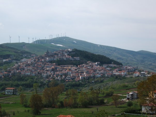
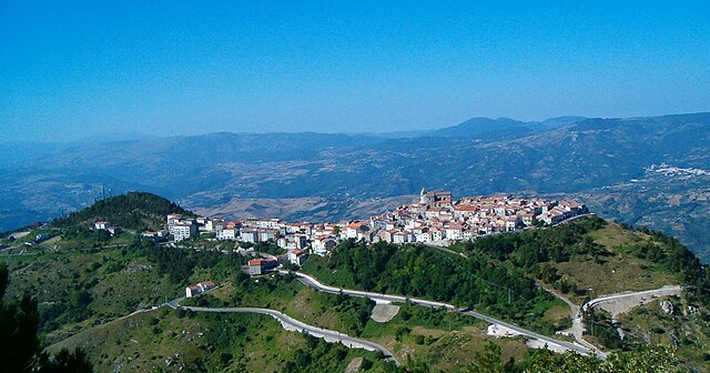
Agnone (Agnone)
.svg)
- Italian comune
 Hiking in Agnone
Agnone is a beautiful town located in the Molise region of Italy, known for its rich history, stunning landscapes, and the surrounding natural beauty, making it a great destination for hiking enthusiasts.
Hiking Trails and Areas
-
Valle del Trigno: This area offers several trails that wind through picturesque valleys and along the Trigno River. The trails vary in difficulty and provide breathtaking views of the surrounding mountains and water.
-
Parco Nazionale d'Abruzzo, Lazio e Molise: While a bit farther from Agnone, this national park features some of the best hiking in the region. It boasts a variety of trails suitable for different skill levels, offering access to varied terrain, wildlife, and stunning alpine scenery.
-
Mount Ocre and Surroundings: For more adventurous hikers, the over-footpath routes leading up to local peaks provide panoramic views of the Apennine mountains. This area is perfect for those looking to experience both challenging hikes and serene nature.
Tips for Hiking in Agnone
-
Best Time to Hike: The ideal months for hiking are spring (April to June) and early fall (September to October) when temperatures are mild and the scenery is vibrant.
-
Gear: Make sure to wear appropriate hiking shoes, carry water, and pack snacks. A map or GPS device is helpful, as some trails may be less marked.
-
Local Guidance: Consider hiring a local guide or joining organized hiking groups, especially if you're unfamiliar with the area, to enhance your experience and ensure safety.
-
Cultural Experience: Take some time to explore the town of Agnone, known for its historic sites and local cuisine. After a day of hiking, enjoying traditional dishes and local wines is a great way to recharge.
Safety Considerations
- Always check the weather conditions before heading out, as conditions can change rapidly in the mountains.
- Inform someone about your hiking plans and expected return time.
- If you're hiking alone, ensure you have proper navigation aids to avoid getting lost.
Hiking in Agnone offers a unique blend of natural beauty and cultural exploration, making it a rewarding experience for outdoor enthusiasts!
- Country:

- Postal Code: 86081
- Local Dialing Code: 0865
- Licence Plate Code: IS
- Coordinates: 41° 48' 38" N, 14° 22' 31" E


- GPS tracks (wikiloc): [Link]
- AboveSeaLevel: 830 м m
- Area: 96.85 sq km
- Population: 5008
- Web site: http://www.comune.agnone.is.it/
- Wikipedia en: wiki(en)
- Wikipedia: wiki(it)
- Wikidata storage: Wikidata: Q221126
- Wikipedia Commons Category: [Link]
- Freebase ID: [/m/0d151y]
- GeoNames ID: Alt: [6540872]
- BnF ID: [12685469d]
- VIAF ID: Alt: [129032746]
- OSM relation ID: [41517]
- Digital Atlas of the Roman Empire ID: [36723]
- ISTAT ID: 094002
- Italian cadastre code: A080
Shares border with regions:
Belmonte del Sannio
- Italian comune
Hiking in Belmonte del Sannio
Belmonte del Sannio is a picturesque village located in the Molise region of Italy, surrounded by beautiful natural landscapes that offer excellent hiking opportunities. The area's unique terrain features rolling hills, dense forests, and stunning views, making it an attractive destination for hikers of all skill levels. Here are some highlights about hiking in and around Belmonte del Sannio:...
- Country:
- Postal Code: 86080
- Local Dialing Code: 0865
- Licence Plate Code: IS
- Coordinates: 41° 49' 0" N, 14° 25' 0" E
- GPS tracks (wikiloc): [Link]
- AboveSeaLevel: 864 м m
- Area: 20.32 sq km
- Population: 735
- Web site: [Link]


Capracotta
- Italian comune
Hiking in Capracotta
Capracotta, located in the Apennine Mountains of Italy, is a delightful destination for hiking enthusiasts. This charming mountain town is situated in the Molise region and offers breathtaking landscapes, rich biodiversity, and a network of well-marked trails suitable for various skill levels....
- Country:
- Postal Code: 86082
- Local Dialing Code: 0865
- Licence Plate Code: IS
- Coordinates: 41° 50' 0" N, 14° 16' 0" E
- GPS tracks (wikiloc): [Link]
- AboveSeaLevel: 1421 м m
- Area: 42.55 sq km
- Population: 874
- Web site: [Link]


Carovilli
- Italian comune
Hiking in Carovilli
Carovilli is a picturesque town located in the Molise region of Italy, surrounded by the beautiful landscapes of the Apennine mountains. Hiking in Carovilli offers a blend of stunning natural scenery, historical sites, and cultural experiences....
- Country:
- Postal Code: 86083
- Local Dialing Code: 0865
- Licence Plate Code: IS
- Coordinates: 41° 43' 0" N, 14° 18' 0" E
- GPS tracks (wikiloc): [Link]
- AboveSeaLevel: 865 м m
- Area: 41.56 sq km
- Population: 1338
- Web site: [Link]
Castelverrino
- Italian comune
Hiking in Castelverrino
Castelverrino, located in Italy, offers beautiful hiking trails set in a picturesque landscape. Nestled near the region of Molise, it is characterized by its stunning natural scenery, rolling hills, and serene atmosphere....
- Country:
- Postal Code: 86080
- Local Dialing Code: 0865
- Licence Plate Code: IS
- Coordinates: 41° 46' 0" N, 14° 24' 0" E
- GPS tracks (wikiloc): [Link]
- AboveSeaLevel: 600 м m
- Area: 6.2 sq km
- Population: 107
- Web site: [Link]


Pescolanciano
- Italian comune
Hiking in Pescolanciano
Pescolanciano is a charming village located in the Molise region of Italy, surrounded by beautiful landscapes and rich natural features that make it a great destination for hiking enthusiasts. Here are some key points about hiking in and around Pescolanciano:...
- Country:
- Postal Code: 86097
- Local Dialing Code: 0865
- Licence Plate Code: IS
- Coordinates: 41° 41' 0" N, 14° 20' 0" E
- GPS tracks (wikiloc): [Link]
- AboveSeaLevel: 800 м m
- Area: 34.73 sq km
- Population: 848
- Web site: [Link]


Pescopennataro
- Italian comune
Hiking in Pescopennataro
Pescopennataro is a charming village located in the Molise region of Italy, nestled in the Apennine mountains. This picturesque area is a great destination for hiking enthusiasts, offering scenic trails and breathtaking views. Here are some key points to consider when hiking in and around Pescopennataro:...
- Country:
- Postal Code: 86080
- Local Dialing Code: 0865
- Licence Plate Code: IS
- Coordinates: 41° 52' 41" N, 14° 17' 39" E
- GPS tracks (wikiloc): [Link]
- AboveSeaLevel: 1190 м m
- Area: 18.84 sq km
- Population: 273
- Web site: [Link]


Pietrabbondante
- Italian comune
Hiking in Pietrabbondante
Pietrabbondante, located in the Molise region of Italy, offers a unique hiking experience with its beautiful landscapes, historical significance, and the opportunity to explore rugged terrain. Here are some key highlights of hiking in this charming area:...
- Country:
- Postal Code: 86085
- Local Dialing Code: 0865
- Licence Plate Code: IS
- Coordinates: 41° 45' 0" N, 14° 23' 0" E
- GPS tracks (wikiloc): [Link]
- AboveSeaLevel: 1027 м m
- Area: 27.44 sq km
- Population: 735
- Web site: [Link]


Poggio Sannita
- Italian comune
Hiking in Poggio Sannita
Poggio Sannita, a charming town located in the Molise region of Italy, offers beautiful hiking opportunities for outdoor enthusiasts. Nestled in the Apennine Mountains, this area is characterized by stunning landscapes, rich biodiversity, and a variety of trails suitable for different skill levels. Here are some highlights and tips for hiking in and around Poggio Sannita:...
- Country:
- Postal Code: 86086
- Local Dialing Code: 0865
- Licence Plate Code: IS
- Coordinates: 41° 46' 40" N, 14° 24' 46" E
- GPS tracks (wikiloc): [Link]
- AboveSeaLevel: 705 м m
- Area: 25.74 sq km
- Population: 647
- Web site: [Link]


Vastogirardi
- Italian comune
Hiking in Vastogirardi
Vastogirardi is a delightful hidden gem located in the Molise region of Italy, known for its stunning landscapes, rich history, and outdoor recreational opportunities. Here are some highlights of hiking in Vastogirardi:...
- Country:
- Postal Code: 86089
- Local Dialing Code: 0865
- Licence Plate Code: IS
- Coordinates: 41° 46' 0" N, 14° 16' 0" E
- GPS tracks (wikiloc): [Link]
- AboveSeaLevel: 1200 м m
- Area: 60.71 sq km
- Population: 684
- Web site: [Link]

Castiglione Messer Marino
- Italian comune
Hiking in Castiglione Messer Marino
Castiglione Messer Marino is a charming village in the Abruzzo region of Italy, known for its beautiful landscapes, rich history, and traditional architecture. The area is surrounded by the stunning scenery of the Abruzzo National Park and offers a variety of hiking opportunities for both novice and experienced hikers....
- Country:
- Postal Code: 66033
- Local Dialing Code: 0873
- Licence Plate Code: CH
- Coordinates: 41° 52' 0" N, 14° 27' 0" E
- GPS tracks (wikiloc): [Link]
- AboveSeaLevel: 1081 м m
- Area: 47.99 sq km
- Population: 1712
- Web site: [Link]


Rosello
- Italian comune
Hiking in Rosello
Hiking in Rosello, a location known for its natural beauty and scenic trails, offers a variety of experiences for outdoor enthusiasts. While specific details about the area can vary, here are some general highlights and tips for hiking in Rosello:...
- Country:
- Postal Code: 66040
- Local Dialing Code: 0872
- Licence Plate Code: CH
- Coordinates: 41° 54' 4" N, 14° 20' 57" E
- GPS tracks (wikiloc): [Link]
- AboveSeaLevel: 927 м m
- Area: 19.23 sq km
- Population: 226
- Web site: [Link]

Schiavi di Abruzzo
- Italian comune
Hiking in Schiavi di Abruzzo
Schiavi di Abruzzo is a charming village located in the province of Chieti, nestled in the heart of the Apennine Mountains in Italy. Hiking in this area offers beautiful landscapes, rich biodiversity, and a chance to experience the local culture and historical sites....
- Country:
- Postal Code: 66045
- Local Dialing Code: 0873
- Licence Plate Code: CH
- Coordinates: 41° 48' 58" N, 14° 29' 5" E
- GPS tracks (wikiloc): [Link]
- AboveSeaLevel: 1172 м m
- Area: 45.58 sq km
- Population: 815
- Web site: [Link]