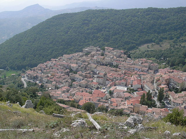
Pescolanciano (Pescolanciano)
.svg)
- Italian comune
 Hiking in Pescolanciano
Pescolanciano is a charming village located in the Molise region of Italy, surrounded by beautiful landscapes and rich natural features that make it a great destination for hiking enthusiasts. Here are some key points about hiking in and around Pescolanciano:
Natural Beauty
- Scenic Views: The area offers stunning views of the Apennine Mountains and surrounding valleys, making for breathtaking hiking experiences.
- Flora and Fauna: The region is home to diverse plant and animal life, which can be observed while hiking. Keep an eye out for local wildlife along the trails.
Hiking Trails
- Various Trails: There are various hiking trails ranging from easy walks for beginners to more challenging hikes for experienced trekkers.
- Local Guidance: Consider hiring a local guide or joining a hiking group to explore the best trails and learn about the area’s flora, fauna, and history along the way.
Nearby Attractions
- Regional Parks: The nearby Monti della Laga and other regional parks offer a broader range of hiking opportunities, including well-marked trails with different levels of difficulty.
- Cultural Sites: While hiking, you can also discover historical sites, medieval villages, and ancient ruins that provide cultural enrichment to your outdoor adventure.
Preparing for Your Hike
- Gear and Supplies: Always wear appropriate hiking gear, including sturdy boots, weather-appropriate clothing, and carry enough water, snacks, and a map or GPS device.
- Weather Awareness: Before heading out, check the weather forecast and be prepared for sudden changes, especially in mountainous areas.
Safety Tips
- Stay on Marked Trails: To ensure safety and minimize environmental impact, stick to designated trails.
- Travel in Groups: If possible, hike with others. It’s safer and more enjoyable to share the experience.
Pescolanciano’s rich natural environment and picturesque landscapes make it a fantastic locale for hiking, whether you're looking for a peaceful stroll or an exhilarating trek. Enjoy your outdoor adventures!
- Country:

- Postal Code: 86097
- Local Dialing Code: 0865
- Licence Plate Code: IS
- Coordinates: 41° 41' 0" N, 14° 20' 0" E


- GPS tracks (wikiloc): [Link]
- AboveSeaLevel: 800 м m
- Area: 34.73 sq km
- Population: 848
- Web site: http://www.comune.pescolanciano.is.it/
- Wikipedia en: wiki(en)
- Wikipedia: wiki(it)
- Wikidata storage: Wikidata: Q279328
- Wikipedia Commons Category: [Link]
- Freebase ID: [/m/0gq_mq]
- GeoNames ID: Alt: [6537952]
- VIAF ID: Alt: [234351113]
- OSM relation ID: [41456]
- UN/LOCODE: [ITELC]
- Digital Atlas of the Roman Empire ID: [26463]
- ISTAT ID: 094032
- Italian cadastre code: G495
Shares border with regions:


Agnone
- Italian comune
Hiking in Agnone
Agnone is a beautiful town located in the Molise region of Italy, known for its rich history, stunning landscapes, and the surrounding natural beauty, making it a great destination for hiking enthusiasts....
- Country:
- Postal Code: 86081
- Local Dialing Code: 0865
- Licence Plate Code: IS
- Coordinates: 41° 48' 38" N, 14° 22' 31" E
- GPS tracks (wikiloc): [Link]
- AboveSeaLevel: 830 м m
- Area: 96.85 sq km
- Population: 5008
- Web site: [Link]


Carovilli
- Italian comune
Hiking in Carovilli
Carovilli is a picturesque town located in the Molise region of Italy, surrounded by the beautiful landscapes of the Apennine mountains. Hiking in Carovilli offers a blend of stunning natural scenery, historical sites, and cultural experiences....
- Country:
- Postal Code: 86083
- Local Dialing Code: 0865
- Licence Plate Code: IS
- Coordinates: 41° 43' 0" N, 14° 18' 0" E
- GPS tracks (wikiloc): [Link]
- AboveSeaLevel: 865 м m
- Area: 41.56 sq km
- Population: 1338
- Web site: [Link]
Chiauci
- Italian comune
Hiking in Chiauci
Chiauci is a small town in the Abruzzo region of Italy, situated on the border of Molise. It is known for its beautiful landscapes, rich history, and charming architecture. Hiking in the Chiauci area offers a variety of trails that showcase the stunning natural beauty of the Apennine Mountains....
- Country:
- Postal Code: 86090
- Local Dialing Code: 0865
- Licence Plate Code: IS
- Coordinates: 41° 41' 0" N, 14° 23' 0" E
- GPS tracks (wikiloc): [Link]
- AboveSeaLevel: 879 м m
- Area: 15.85 sq km
- Population: 221
- Web site: [Link]
Civitanova del Sannio
- Italian comune
Hiking in Civitanova del Sannio
Civitanova del Sannio is a charming village located in the Molise region of Italy, surrounded by beautiful landscapes, rolling hills, and natural beauty that makes it a great destination for hiking enthusiasts. Here are some highlights for hiking in and around Civitanova del Sannio:...
- Country:
- Postal Code: 86094
- Local Dialing Code: 0865
- Licence Plate Code: IS
- Coordinates: 41° 40' 0" N, 14° 24' 0" E
- GPS tracks (wikiloc): [Link]
- AboveSeaLevel: 656 м m
- Area: 50.47 sq km
- Population: 918
- Web site: [Link]
Miranda, Molise
- Italian comune
Hiking in Miranda, Molise
Miranda is a charming village located in the region of Molise, Italy, known for its beautiful landscapes and rich historical context. Hiking in this area offers a unique experience, combining nature, culture, and stunning views....
- Country:
- Postal Code: 86080
- Local Dialing Code: 0865
- Licence Plate Code: IS
- Coordinates: 41° 39' 0" N, 14° 15' 0" E
- GPS tracks (wikiloc): [Link]
- AboveSeaLevel: 860 м m
- Area: 22.15 sq km
- Population: 1022
- Web site: [Link]


Pietrabbondante
- Italian comune
Hiking in Pietrabbondante
Pietrabbondante, located in the Molise region of Italy, offers a unique hiking experience with its beautiful landscapes, historical significance, and the opportunity to explore rugged terrain. Here are some key highlights of hiking in this charming area:...
- Country:
- Postal Code: 86085
- Local Dialing Code: 0865
- Licence Plate Code: IS
- Coordinates: 41° 45' 0" N, 14° 23' 0" E
- GPS tracks (wikiloc): [Link]
- AboveSeaLevel: 1027 м m
- Area: 27.44 sq km
- Population: 735
- Web site: [Link]
Sessano del Molise
- Italian comune
Hiking in Sessano del Molise
Sessano del Molise is a picturesque village located in the Molise region of Italy, surrounded by beautiful landscapes that are perfect for hiking enthusiasts. The area offers a variety of trails that vary in difficulty, allowing hikers of all skill levels to enjoy the natural beauty of the region....
- Country:
- Postal Code: 86097
- Local Dialing Code: 0865
- Licence Plate Code: IS
- Coordinates: 41° 38' 0" N, 14° 20' 0" E
- GPS tracks (wikiloc): [Link]
- AboveSeaLevel: 796 м m
- Area: 25.32 sq km
- Population: 730
- Web site: [Link]