
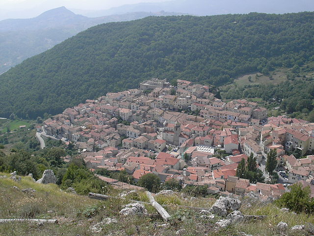
Carovilli (Carovilli)
.svg)
- Italian comune
 Hiking in Carovilli
Carovilli is a picturesque town located in the Molise region of Italy, surrounded by the beautiful landscapes of the Apennine mountains. Hiking in Carovilli offers a blend of stunning natural scenery, historical sites, and cultural experiences.
Hiking Trails
-
Monte Civitella: This is one of the most popular hiking destinations near Carovilli. The trail offers breathtaking views of the surrounding mountains and valleys. The hike can be moderately challenging, making it suitable for those with some hiking experience.
-
Parco Nazionale d’Abruzzo, Lazio e Molise: While a bit of a drive from Carovilli, this national park is well worth the visit. It offers a variety of trails ranging from easy walks to more challenging hikes, allowing hikers to experience rich biodiversity, including wildlife like wolves and Marsican bears.
-
Local Paths: There are numerous well-marked paths in and around Carovilli, which connect the town to neighboring villages and stunning overlooks. These trails can often be explored on foot and are ideal for leisurely strolls or more intense hikes.
Best Time to Hike
The best times for hiking in Carovilli are during the spring (April to June) and early autumn (September to October). During these seasons, the weather is generally mild, the vegetation is lush, and there are fewer tourists.
Tips for Hiking in Carovilli
- Check the Weather: Always check the local weather conditions before heading out, as the weather can change rapidly in the mountains.
- Wear Appropriate Gear: Sturdy hiking boots, comfortable clothing, and a hat for sun protection will enhance your hiking experience.
- Stay Hydrated: Bring plenty of water, especially on longer hikes.
- Map and Navigation: While many trails are marked, having a map or GPS can be helpful, especially if you venture into less populated areas.
- Respect Nature: Follow local guidelines for nature conservation, taking care not to disturb wildlife or leave litter behind.
Cultural Aspects
Hiking in Carovilli also provides opportunities to explore local culture. You can enjoy traditional cuisine at village trattorias, learn about local history, and interact with friendly locals. The combination of natural beauty and rich cultural heritage makes hiking in this area a unique experience.
In summary, hiking in Carovilli can offer both stunning natural landscapes and an appreciation for the local culture, making it a rewarding activity for both avid hikers and casual walkers.
- Country:

- Postal Code: 86083
- Local Dialing Code: 0865
- Licence Plate Code: IS
- Coordinates: 41° 43' 0" N, 14° 18' 0" E


- GPS tracks (wikiloc): [Link]
- AboveSeaLevel: 865 м m
- Area: 41.56 sq km
- Population: 1338
- Web site: http://www.comune.carovilli.is.it
- Wikipedia en: wiki(en)
- Wikipedia: wiki(it)
- Wikidata storage: Wikidata: Q278920
- Wikipedia Commons Category: [Link]
- Freebase ID: [/m/0gq_3k]
- GeoNames ID: Alt: [6540873]
- VIAF ID: Alt: [132680498]
- OSM relation ID: [41466]
- TGN ID: [1043905]
- Digital Atlas of the Roman Empire ID: [26462]
- ISTAT ID: 094007
- Italian cadastre code: B810
Shares border with regions:


Agnone
- Italian comune
Hiking in Agnone
Agnone is a beautiful town located in the Molise region of Italy, known for its rich history, stunning landscapes, and the surrounding natural beauty, making it a great destination for hiking enthusiasts....
- Country:
- Postal Code: 86081
- Local Dialing Code: 0865
- Licence Plate Code: IS
- Coordinates: 41° 48' 38" N, 14° 22' 31" E
- GPS tracks (wikiloc): [Link]
- AboveSeaLevel: 830 м m
- Area: 96.85 sq km
- Population: 5008
- Web site: [Link]
Miranda, Molise
- Italian comune
Hiking in Miranda, Molise
Miranda is a charming village located in the region of Molise, Italy, known for its beautiful landscapes and rich historical context. Hiking in this area offers a unique experience, combining nature, culture, and stunning views....
- Country:
- Postal Code: 86080
- Local Dialing Code: 0865
- Licence Plate Code: IS
- Coordinates: 41° 39' 0" N, 14° 15' 0" E
- GPS tracks (wikiloc): [Link]
- AboveSeaLevel: 860 м m
- Area: 22.15 sq km
- Population: 1022
- Web site: [Link]


Pescolanciano
- Italian comune
Hiking in Pescolanciano
Pescolanciano is a charming village located in the Molise region of Italy, surrounded by beautiful landscapes and rich natural features that make it a great destination for hiking enthusiasts. Here are some key points about hiking in and around Pescolanciano:...
- Country:
- Postal Code: 86097
- Local Dialing Code: 0865
- Licence Plate Code: IS
- Coordinates: 41° 41' 0" N, 14° 20' 0" E
- GPS tracks (wikiloc): [Link]
- AboveSeaLevel: 800 м m
- Area: 34.73 sq km
- Population: 848
- Web site: [Link]

Roccasicura
- Italian comune
Hiking in Roccasicura
Roccasicura, a small town in the Molise region of Italy, offers a beautiful setting for hiking enthusiasts. The area is characterized by its picturesque landscapes, rolling hills, and nearby mountains. Here are some key points about hiking in and around Roccasicura:...
- Country:
- Postal Code: 86080
- Local Dialing Code: 0865
- Licence Plate Code: IS
- Coordinates: 41° 42' 0" N, 14° 14' 0" E
- GPS tracks (wikiloc): [Link]
- AboveSeaLevel: 742 м m
- Area: 28.61 sq km
- Population: 559
- Web site: [Link]


Vastogirardi
- Italian comune
Hiking in Vastogirardi
Vastogirardi is a delightful hidden gem located in the Molise region of Italy, known for its stunning landscapes, rich history, and outdoor recreational opportunities. Here are some highlights of hiking in Vastogirardi:...
- Country:
- Postal Code: 86089
- Local Dialing Code: 0865
- Licence Plate Code: IS
- Coordinates: 41° 46' 0" N, 14° 16' 0" E
- GPS tracks (wikiloc): [Link]
- AboveSeaLevel: 1200 м m
- Area: 60.71 sq km
- Population: 684
- Web site: [Link]