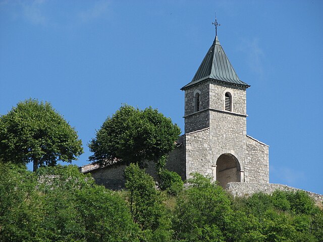
Ambléon (Ambléon)

- commune in Ain, France
 Hiking in Ambléon
Ambléon is a charming village situated in the Auvergne-Rhône-Alpes region of France, nestled in the foothills of the French Alps. The area is known for its stunning landscapes, offering a variety of hiking opportunities that cater to different skill levels.
Hiking Trails
-
Local Trails: The region features numerous well-marked trails that take you through picturesque scenery, including forests, meadows, and views of the surrounding mountains. These paths can vary in difficulty, suitable for both casual walkers and more experienced hikers.
-
Breathtaking Views: Many trails lead to viewpoints where you can enjoy panoramic vistas of the Chartreuse Mountains and the surrounding valleys. During clear days, the sight is truly breathtaking.
-
Flora and Fauna: Hikers can also encounter diverse flora and fauna along the trails. The region is home to various wildlife, and it's common to see birds, deer, and other animals in their natural habitat.
Recommended Hikes
- Sentier de la Roche: A moderate hike that offers beautiful views and a chance to explore the local geology.
- Col de la Cluse: A slightly more challenging hike that rewards with stunning vistas and a chance to experience the alpine environment.
Best Time to Hike
The best seasons for hiking in Ambléon are late spring to early autumn (May to September). The weather is generally mild, and the trails are usually accessible during this time. Always check local conditions since some higher elevation trails may still have snow in late spring and early autumn.
Tips for Hiking in Ambléon
- Gear Up: Wear good hiking shoes and bring proper gear depending on the weather forecast.
- Stay Hydrated: Carry enough water, especially during warmer months.
- Local Knowledge: Consider hiring a local guide or visiting the tourism office for maps and advice on the best trails.
- Respect Nature: Follow Leave No Trace principles to keep the environment pristine for future hikers.
Overall, hiking in Ambléon can be a delightful experience, combining physical activity with the exploration of one of France's beautiful mountainous regions. Enjoy your adventure!
- Country:

- Postal Code: 01300
- Coordinates: 45° 44' 58" N, 5° 36' 5" E


- GPS tracks (wikiloc): [Link]
- Area: 5.88 sq km
- Population: 109
- Wikipedia en: wiki(en)
- Wikipedia: wiki(fr)
- Wikidata storage: Wikidata: Q193812
- Wikipedia Commons Category: [Link]
- Wikipedia Commons Maps Category: [Link]
- Freebase ID: [/m/07tnnj]
- Freebase ID: [/m/07tnnj]
- GeoNames ID: Alt: [3037918]
- GeoNames ID: Alt: [3037918]
- SIREN number: [210100061]
- SIREN number: [210100061]
- INSEE municipality code: 01006
- INSEE municipality code: 01006
Shares border with regions:

Conzieu
- commune in Ain, France
Hiking in Conzieu
Conzieu is a small village located in the Ain department of the Auvergne-Rhône-Alpes region in France. While it may not be as widely known as some other hiking destinations in the Alps, it offers various opportunities for nature lovers and hikers to explore its beautiful landscapes....
- Country:
- Postal Code: 01300
- Coordinates: 45° 43' 34" N, 5° 36' 26" E
- GPS tracks (wikiloc): [Link]
- Area: 7.2 sq km
- Population: 146

Saint-Germain-les-Paroisses
- commune in Ain, France
Hiking in Saint-Germain-les-Paroisses
Saint-Germain-les-Paroisses is a picturesque commune located in the Auvergne-Rhône-Alpes region of France. While it may not be one of the most famous hiking destinations, it offers a charming landscape that can be explored through various trails suitable for hiking enthusiasts....
- Country:
- Postal Code: 01300
- Coordinates: 45° 46' 25" N, 5° 37' 5" E
- GPS tracks (wikiloc): [Link]
- Area: 16.27 sq km
- Population: 426
- Web site: [Link]

Marchamp
- commune in Ain, France
Hiking in Marchamp
Marchamp is not a widely recognized destination, and it may not have specific trails or hiking information readily available in common hiking resources. However, if you meant a specific trail system, park, or destination within a region like the French Alps or elsewhere, please clarify that....
- Country:
- Postal Code: 01680
- Coordinates: 45° 46' 42" N, 5° 32' 54" E
- GPS tracks (wikiloc): [Link]
- Area: 13.11 sq km
- Population: 130
Innimond
- commune in Ain, France
Hiking in Innimond
Innimond is a beautiful area for hiking, characterized by its stunning natural scenery and diverse terrain. Although specific trail details may vary, here are some general tips and information about hiking in the Innimond region:...
- Country:
- Postal Code: 01680
- Coordinates: 45° 46' 58" N, 5° 34' 21" E
- GPS tracks (wikiloc): [Link]
- Area: 13.44 sq km
- Population: 106
Colomieu
- commune in Ain, France
Hiking in Colomieu
Colomieu is a small commune located in the Auvergne-Rhône-Alpes region of France, known for its beautiful natural landscapes and outdoor activities. While it may not be as widely recognized as some larger hiking destinations, it offers various opportunities for those seeking to explore the great outdoors in a picturesque environment....
- Country:
- Postal Code: 01300
- Coordinates: 45° 43' 59" N, 5° 37' 19" E
- GPS tracks (wikiloc): [Link]
- Area: 5.96 sq km
- Population: 130
- Web site: [Link]
Lhuis
- commune in Ain, France
Hiking in Lhuis
Lhuis is a charming commune located in the Ain department of the Auvergne-Rhône-Alpes region of France. Nestled near the foothills of the Alps, it provides a beautiful backdrop for outdoor activities, including hiking. While Lhuis itself might be more quiet and less well-known than larger hiking destinations, it offers access to a range of trails that cater to different skill levels and preferences....
- Country:
- Postal Code: 01680
- Coordinates: 45° 44' 48" N, 5° 32' 0" E
- GPS tracks (wikiloc): [Link]
- Area: 24.43 sq km
- Population: 887
- Web site: [Link]