
Angoulême (Angoulême)

- commune in Charente, France
- Country:

- Postal Code: 16000
- Coordinates: 45° 38' 58" N, 0° 9' 34" E


- GPS tracks (wikiloc): [Link]
- AboveSeaLevel: 100 м m
- Area: 21.85 sq km
- Population: 42081
- Web site: http://www.angouleme.fr
- Wikipedia en: wiki(en)
- Wikipedia: wiki(fr)
- Wikidata storage: Wikidata: Q134346
- Wikipedia Commons Category: [Link]
- Wikipedia Commons Maps Category: [Link]
- Freebase ID: [/m/0lgy_]
- Freebase ID: [/m/0lgy_]
- Freebase ID: [/m/0lgy_]
- GeoNames ID: Alt: [3037598]
- GeoNames ID: Alt: [3037598]
- GeoNames ID: Alt: [3037598]
- SIREN number: [211600150]
- SIREN number: [211600150]
- SIREN number: [211600150]
- BnF ID: [152484540]
- BnF ID: [152484540]
- BnF ID: [152484540]
- VIAF ID: Alt: [137216647]
- VIAF ID: Alt: [137216647]
- VIAF ID: Alt: [137216647]
- GND ID: Alt: [4079784-3]
- GND ID: Alt: [4079784-3]
- GND ID: Alt: [4079784-3]
- archINFORM location ID: [7134]
- archINFORM location ID: [7134]
- archINFORM location ID: [7134]
- Library of Congress authority ID: Alt: [n81071978]
- Library of Congress authority ID: Alt: [n81071978]
- Library of Congress authority ID: Alt: [n81071978]
- PACTOLS thesaurus ID: [pcrtP1tliL6VST]
- PACTOLS thesaurus ID: [pcrtP1tliL6VST]
- PACTOLS thesaurus ID: [pcrtP1tliL6VST]
- MusicBrainz area ID: [d4d7d119-bb72-4dcc-8213-09b53b18c1b1]
- MusicBrainz area ID: [d4d7d119-bb72-4dcc-8213-09b53b18c1b1]
- MusicBrainz area ID: [d4d7d119-bb72-4dcc-8213-09b53b18c1b1]
- SUDOC authorities ID: [02839593X]
- SUDOC authorities ID: [02839593X]
- SUDOC authorities ID: [02839593X]
- Encyclopædia Britannica Online ID: [place/Angouleme]
- Encyclopædia Britannica Online ID: [place/Angouleme]
- Encyclopædia Britannica Online ID: [place/Angouleme]
- Gran Enciclopèdia Catalana ID: [0004154]
- Gran Enciclopèdia Catalana ID: [0004154]
- Gran Enciclopèdia Catalana ID: [0004154]
- Encyclopædia Universalis ID: [angouleme]
- Encyclopædia Universalis ID: [angouleme]
- Encyclopædia Universalis ID: [angouleme]
- EMLO location ID: [58c82002-287b-4076-b96a-53e5e664266e]
- EMLO location ID: [58c82002-287b-4076-b96a-53e5e664266e]
- EMLO location ID: [58c82002-287b-4076-b96a-53e5e664266e]
- Great Russian Encyclopedia Online ID: [1822068]
- Great Russian Encyclopedia Online ID: [1822068]
- Great Russian Encyclopedia Online ID: [1822068]
- Digital Atlas of the Roman Empire ID: [146]
- Digital Atlas of the Roman Empire ID: [146]
- Digital Atlas of the Roman Empire ID: [146]
- NE.se ID: [angouleme]
- NE.se ID: [angouleme]
- NE.se ID: [angouleme]
- INSEE municipality code: 16015
- INSEE municipality code: 16015
- INSEE municipality code: 16015
Shares border with regions:

Dirac
- commune in Charente, France
- Country:
- Postal Code: 16410
- Coordinates: 45° 36' 15" N, 0° 14' 54" E
- GPS tracks (wikiloc): [Link]
- AboveSeaLevel: 148 м m
- Area: 29.29 sq km
- Population: 1512
- Web site: [Link]


Soyaux
- commune in Charente, France
- Country:
- Postal Code: 16800
- Coordinates: 45° 38' 25" N, 0° 11' 52" E
- GPS tracks (wikiloc): [Link]
- AboveSeaLevel: 161 м m
- Area: 12.76 sq km
- Population: 9295
- Web site: [Link]

Puymoyen
- commune in Charente, France
- Country:
- Postal Code: 16400
- Coordinates: 45° 36' 49" N, 0° 10' 51" E
- GPS tracks (wikiloc): [Link]
- Area: 7.26 sq km
- Population: 2396
- Web site: [Link]

Saint-Michel
- commune in Charente, France
- Country:
- Postal Code: 16470
- Coordinates: 45° 38' 31" N, 0° 6' 23" E
- GPS tracks (wikiloc): [Link]
- Area: 2.46 sq km
- Population: 3253
- Web site: [Link]

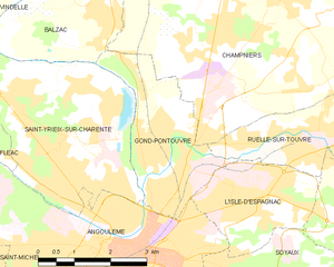
Gond-Pontouvre
- commune in Charente, France
- Country:
- Postal Code: 16160
- Coordinates: 45° 40' 9" N, 0° 9' 58" E
- GPS tracks (wikiloc): [Link]
- AboveSeaLevel: 38 м m
- Area: 7.45 sq km
- Population: 5951
- Web site: [Link]

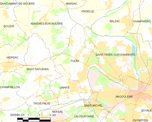
Fléac
- commune in Charente, France
- Country:
- Postal Code: 16730
- Coordinates: 45° 39' 55" N, 0° 5' 37" E
- GPS tracks (wikiloc): [Link]
- Area: 12.6 sq km
- Population: 3708
- Web site: [Link]


L'Isle-d'Espagnac
- commune in Charente, France
- Country:
- Postal Code: 16340
- Coordinates: 45° 39' 41" N, 0° 11' 59" E
- GPS tracks (wikiloc): [Link]
- Area: 5.95 sq km
- Population: 5514
- Web site: [Link]


Saint-Yrieix-sur-Charente
- commune in Charente, France
- Country:
- Postal Code: 16710
- Coordinates: 45° 40' 31" N, 0° 7' 39" E
- GPS tracks (wikiloc): [Link]
- AboveSeaLevel: 175 м m
- Area: 14.65 sq km
- Population: 7206
- Web site: [Link]

La Couronne
- commune in Charente, France
- Country:
- Postal Code: 16400
- Coordinates: 45° 36' 27" N, 0° 6' 0" E
- GPS tracks (wikiloc): [Link]
- Area: 28.82 sq km
- Population: 7656
- Web site: [Link]