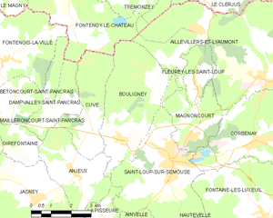
Anjeux (Anjeux)

- commune in Haute-Saône, France
- Country:

- Postal Code: 70800
- Coordinates: 47° 52' 50" N, 6° 12' 32" E


- GPS tracks (wikiloc): [Link]
- Area: 8.71 sq km
- Population: 142
- Wikipedia en: wiki(en)
- Wikipedia: wiki(fr)
- Wikidata storage: Wikidata: Q551433
- Wikipedia Commons Category: [Link]
- Freebase ID: [/m/03nt0xg]
- GeoNames ID: Alt: [6450784]
- SIREN number: [217000231]
- BnF ID: [15272417z]
- VIAF ID: Alt: [244602156]
- INSEE municipality code: 70023
Shares border with regions:


Dampvalley-Saint-Pancras
- commune in Haute-Saône, France
- Country:
- Postal Code: 70210
- Coordinates: 47° 54' 33" N, 6° 11' 50" E
- GPS tracks (wikiloc): [Link]
- Area: 4.65 sq km
- Population: 36


Cuve
- commune in Haute-Saône, France
- Country:
- Postal Code: 70800
- Coordinates: 47° 54' 13" N, 6° 13' 16" E
- GPS tracks (wikiloc): [Link]
- Area: 8.1 sq km
- Population: 152

Bouligney
- commune in Haute-Saône, France
- Country:
- Postal Code: 70800
- Coordinates: 47° 53' 42" N, 6° 14' 26" E
- GPS tracks (wikiloc): [Link]
- Area: 14.2 sq km
- Population: 420

Girefontaine
- commune in Haute-Saône, France
- Country:
- Postal Code: 70210
- Coordinates: 47° 53' 38" N, 6° 10' 31" E
- GPS tracks (wikiloc): [Link]
- Area: 3.56 sq km
- Population: 39


Saint-Loup-sur-Semouse
- commune in Haute-Saône, France
- Country:
- Postal Code: 70800
- Coordinates: 47° 53' 5" N, 6° 16' 24" E
- GPS tracks (wikiloc): [Link]
- Area: 16.54 sq km
- Population: 3256
- Web site: [Link]


La Pisseure
- commune in Haute-Saône, France
- Country:
- Postal Code: 70800
- Coordinates: 47° 51' 40" N, 6° 13' 36" E
- GPS tracks (wikiloc): [Link]
- Area: 2.3 sq km
- Population: 36


Jasney
- commune in Haute-Saône, France
- Country:
- Postal Code: 70800
- Coordinates: 47° 52' 11" N, 6° 10' 59" E
- GPS tracks (wikiloc): [Link]
- Area: 13.02 sq km
- Population: 247