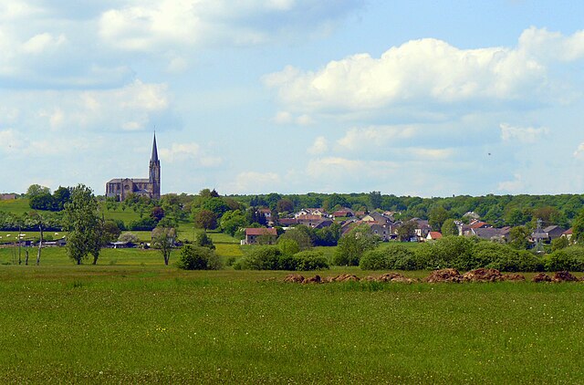
Saint-Loup-sur-Semouse (Saint-Loup-sur-Semouse)

- commune in Haute-Saône, France
- Country:

- Postal Code: 70800
- Coordinates: 47° 53' 5" N, 6° 16' 24" E


- GPS tracks (wikiloc): [Link]
- Area: 16.54 sq km
- Population: 3256
- Web site: http://www.saint-loup.eu/
- Wikipedia en: wiki(en)
- Wikipedia: wiki(fr)
- Wikidata storage: Wikidata: Q901506
- Wikipedia Commons Category: [Link]
- Freebase ID: [/m/03nvsjz]
- GeoNames ID: Alt: [2978688]
- SIREN number: [217004670]
- BnF ID: [152728590]
- VIAF ID: Alt: [298923026]
- PACTOLS thesaurus ID: [pcrtNvNBt027nF]
- INSEE municipality code: 70467
Shares border with regions:


Aillevillers-et-Lyaumont
- commune in Haute-Saône, France
- Country:
- Postal Code: 70320
- Coordinates: 47° 55' 13" N, 6° 20' 9" E
- GPS tracks (wikiloc): [Link]
- Area: 36.3 sq km
- Population: 1584
- Web site: [Link]

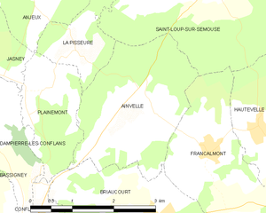
Ainvelle, Haute-Saône
- commune in Haute-Saône, France
- Country:
- Postal Code: 70800
- Coordinates: 47° 50' 48" N, 6° 15' 2" E
- GPS tracks (wikiloc): [Link]
- Area: 6.75 sq km
- Population: 150


Anjeux
- commune in Haute-Saône, France
- Country:
- Postal Code: 70800
- Coordinates: 47° 52' 50" N, 6° 12' 32" E
- GPS tracks (wikiloc): [Link]
- Area: 8.71 sq km
- Population: 142

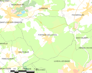
Fontaine-lès-Luxeuil
- commune in Haute-Saône, France
- Country:
- Postal Code: 70800
- Coordinates: 47° 51' 20" N, 6° 20' 5" E
- GPS tracks (wikiloc): [Link]
- Area: 27.73 sq km
- Population: 1379


Francalmont
- commune in Haute-Saône, France
- Country:
- Postal Code: 70800
- Coordinates: 47° 50' 18" N, 6° 16' 4" E
- GPS tracks (wikiloc): [Link]
- Area: 6.86 sq km
- Population: 118

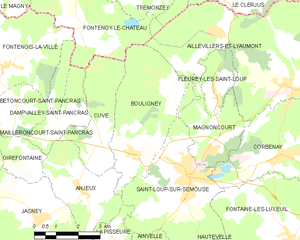
Bouligney
- commune in Haute-Saône, France
- Country:
- Postal Code: 70800
- Coordinates: 47° 53' 42" N, 6° 14' 26" E
- GPS tracks (wikiloc): [Link]
- Area: 14.2 sq km
- Population: 420

Corbenay
- commune in Haute-Saône, France
- Country:
- Postal Code: 70320
- Coordinates: 47° 53' 27" N, 6° 19' 31" E
- GPS tracks (wikiloc): [Link]
- Area: 15.73 sq km
- Population: 1296
- Web site: [Link]

Hautevelle
- commune in Haute-Saône, France
- Country:
- Postal Code: 70800
- Coordinates: 47° 50' 34" N, 6° 17' 2" E
- GPS tracks (wikiloc): [Link]
- Area: 7.78 sq km
- Population: 263


La Pisseure
- commune in Haute-Saône, France
- Country:
- Postal Code: 70800
- Coordinates: 47° 51' 40" N, 6° 13' 36" E
- GPS tracks (wikiloc): [Link]
- Area: 2.3 sq km
- Population: 36

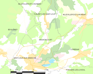
Magnoncourt
- commune in Haute-Saône, France
- Country:
- Postal Code: 70800
- Coordinates: 47° 53' 38" N, 6° 17' 7" E
- GPS tracks (wikiloc): [Link]
- Area: 6.67 sq km
- Population: 430