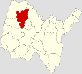
arrondissement of Bourg-en-Bresse (arrondissement de Bourg-en-Bresse)

- arrondissement of France in the Ain Department
 Hiking in arrondissement of Bourg-en-Bresse
The Arrondissement of Bourg-en-Bresse, located in the Ain department of the Auvergne-Rhône-Alpes region in southeastern France, offers a variety of hiking opportunities set against beautiful landscapes, historical sites, and charming villages. Here are some highlights and tips for hiking in this region:
Natural Attractions
-
Dombes Region: Known for its wetlands and abundant wildlife, particularly birdwatching. Trails often weave around lakes and ponds, providing picturesque scenery and serene hiking experiences.
-
Bugey Mountains: To the east of Bourg-en-Bresse, you'll find rolling hills and more rugged terrain. Popular hiking spots such as the Mont de la Charne or the Plateau de Retord offer trails that vary in difficulty and provide stunning views of the Alps on clear days.
-
Parc Naturel Régional du Haut-Jura: While slightly further afield, this national park features breathtaking landscapes, diverse flora and fauna, and numerous marked hiking trails. It's worth a day trip if you're looking for more extensive hiking opportunities.
Cultural and Historical Sites
-
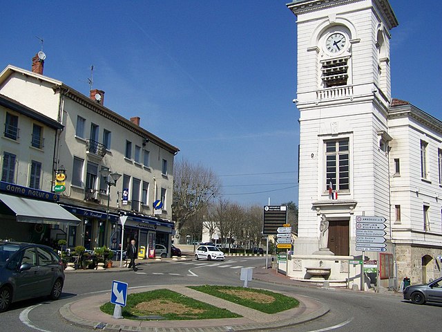
Bourg-en-Bresse: The town itself has trails that incorporate historical landmarks like the Royal Monastery of Brou, which can be a great starting or ending point for hikes. Explore the town’s rich history before or after your hike.
-
Château de Montaigu: A historic castle in the area can also serve as a great destination for hikers seeking scenic routes that lead to historical landmarks.
Hiking Tips
-
Trail Maps and Guides: Use local trail maps (available in tourism offices) to familiarize yourself with the area. The well-marked trails make navigation easier, but having a map can help you find hidden gems.
-
Best Time to Hike: Spring and early autumn offer the best weather for hiking, with mild temperatures and fewer crowds. Summers can be warm and humid, while winters can bring snow, which may be suitable for different activities like snowshoeing in higher elevations.
-
Safety: Always inform someone about your hiking plans, check weather conditions, and consider carrying basic supplies—water, snacks, a first-aid kit, and a charged phone.
-
Local Regulations: Pay attention to local regulations regarding wildlife and natural sites. Some areas may have restrictions to preserve the environment.
In conclusion, the Arrondissement of Bourg-en-Bresse provides a delightful mix of nature and culture, making it an excellent destination for hikers of all levels. Whether you’re looking for scenic walks, birdwatching, or historical exploration, you’ll find plenty to enjoy in this charming region of France. Happy hiking!
- Country:

- Capital: Bourg-en-Bresse
- Coordinates: 46° 10' 0" N, 5° 10' 0" E


- GPS tracks (wikiloc): [Link]
- Population: 328474
- Wikipedia en: wiki(en)
- Wikipedia: wiki(fr)
- Wikidata storage: Wikidata: Q700721
- Freebase ID: [/m/083gqg]
- GeoNames ID: Alt: [3031008]
- INSEE arrondissement code: [012]
- GNS Unique Feature ID: -1414326
Includes regions:


canton of Châtillon-sur-Chalaronne
- canton of France
- Country:
- Capital: Châtillon-sur-Chalaronne
- Coordinates: 46° 7' 18" N, 4° 57' 21" E
- GPS tracks (wikiloc): [Link]
- Area: 252.56 sq km
- Population: 29766

canton of Meximieux
- canton of France
- Country:
- Capital: Meximieux
- Coordinates: 45° 54' 19" N, 5° 11' 43" E
- GPS tracks (wikiloc): [Link]
- Population: 33055

canton of Attignat
- canton of France
Hiking in canton of Attignat
Hiking in the Canton of Attignat, located in the Ain department in the Auvergne-Rhône-Alpes region of France, can be a delightful experience for outdoor enthusiasts. The region is known for its beautiful landscapes, with rolling hills, forests, rivers, and charming rural scenery....
- Country:
- Capital: Attignat
- Coordinates: 46° 15' 22" N, 5° 39' 20" E
- GPS tracks (wikiloc): [Link]
- Population: 24517


canton of Bourg-en-Bresse-1
- canton of France
- Country:
- Capital: Bourg-en-Bresse
- Coordinates: 46° 13' 48" N, 5° 13' 12" E
- GPS tracks (wikiloc): [Link]
- Population: 34451

canton of Bourg-en-Bresse-2
- canton of France
- Country:
- Capital: Bourg-en-Bresse
- Coordinates: 46° 11' 24" N, 5° 13' 12" E
- GPS tracks (wikiloc): [Link]
- Population: 25411

canton of Pont-de-Veyle
- canton of France (until March 2015)
- Country:
- Capital: Pont-de-Veyle
- Coordinates: 46° 15' 49" N, 4° 53' 19" E
- GPS tracks (wikiloc): [Link]
- Area: 123.46 sq km
- Population: 11079

canton of Reyrieux
- canton of France
- Country:
- Capital: Reyrieux
- Coordinates: 45° 56' 0" N, 4° 49' 0" E
- GPS tracks (wikiloc): [Link]
- Area: 142.77 sq km
- Population: 21772

canton of Saint-Trivier-sur-Moignans
- canton of France (until March 2015)
- Country:
- Capital: Saint-Trivier-sur-Moignans
- Coordinates: 46° 4' 24" N, 4° 53' 51" E
- GPS tracks (wikiloc): [Link]
- Area: 190.3 sq km
- Population: 14659


canton of Villars-les-Dombes
- canton of France
- Country:
- Capital: Villars-les-Dombes
- Coordinates: 46° 0' 5" N, 5° 1' 46" E
- GPS tracks (wikiloc): [Link]
- Area: 180.99 sq km
- Population: 32108


canton of Saint-Étienne-du-Bois
- canton of France
Hiking in canton of Saint-Étienne-du-Bois
Hiking in the Canton of Saint-Étienne-du-Bois, located in the Ain department in the Auvergne-Rhône-Alpes region of France, offers a picturesque experience characterized by rolling hills, lush landscapes, and charming villages. Here’s what you can expect when hiking in this area:...
- Country:
- Capital: Saint-Étienne-du-Bois
- Coordinates: 46° 17' 0" N, 5° 17' 0" E
- GPS tracks (wikiloc): [Link]
- Population: 22255


canton of Vonnas
- canton of France
- Country:
- Capital: Vonnas
- Coordinates: 46° 13' 12" N, 4° 59' 24" E
- GPS tracks (wikiloc): [Link]
- Population: 23603


canton of Replonges
- canton of France
- Country:
- Capital: Replonges
- Coordinates: 46° 18' 0" N, 4° 53' 0" E
- GPS tracks (wikiloc): [Link]
- Population: 30841


canton of Ceyzériat
- canton of France (until March 2015)
Hiking in canton of Ceyzériat
The Canton of Ceyzériat, located in the Ain department of the Auvergne-Rhône-Alpes region in eastern France, offers beautiful landscapes and a variety of hiking opportunities. While it may not be as famous as some of the larger national parks or mountain regions in France, it is a charming area with a mix of pastoral landscapes, forests, and rolling hills....
- Country:
- Capital: Ceyzériat
- Coordinates: 46° 10' 44" N, 5° 19' 26" E
- GPS tracks (wikiloc): [Link]
- Population: 25504


canton of Trévoux
- canton of France
- Country:
- Capital: Trévoux
- Coordinates: 45° 56' 28" N, 4° 46' 30" E
- GPS tracks (wikiloc): [Link]
- Area: 29.12 sq km
- Population: 32136


canton of Miribel
- canton of France
- Country:
- Capital: Miribel
- Coordinates: 45° 49' 33" N, 4° 57' 16" E
- GPS tracks (wikiloc): [Link]
- Area: 52.63 sq km
- Population: 27756