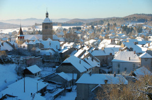
arrondissement of Lons-le-Saunier (arrondissement de Lons-le-Saunier)

- arrondissement of France
 Hiking in arrondissement of Lons-le-Saunier
The Arrondissement of Lons-le-Saunier, located in the Jura department of France, offers a wealth of hiking opportunities set against a backdrop of stunning natural scenery, rolling hills, and a rich cultural landscape. This area is part of the Jura Mountains, which are known for their diverse landscapes that include forests, lakes, rivers, and charming villages.
Key Hiking Areas
-
Haut-Jura Regional Nature Park: This protected area is a fantastic destination for hiking enthusiasts. The park boasts numerous trails that showcase the Jura's natural beauty, including its limestone cliffs, waterfalls, and lush valleys. Trails vary in difficulty, accommodating both beginners and experienced hikers.
-
The Cascades du Hérisson: A remarkable site featuring a series of waterfalls, the Cascades du Hérisson is accessible by well-marked trails. The hike allows you to explore the beautiful cascades and the surrounding forested area.
-
Lake Vouglans: This artificial lake is surrounded by hiking paths that offer scenic views of the water and the surrounding mountains. The trails around the lake are great for leisurely hikes and family outings.
-
The Mont d'Or and the Val de Loue: These areas offer more challenging hikes with rewarding panoramas. Hikers can enjoy the diverse flora and fauna and the remarkable rock formations of the region.
Trail Difficulty and Preparation
- Difficulty Levels: The region provides a range of trails from easy to difficult. Beginners can find flat, well-maintained paths in areas like Lake Vouglans, while experienced hikers can tackle the more rugged terrain in the Haut-Jura Regional Nature Park.
- Weather and Terrain: The Jura Mountains can have variable weather. Make sure to check the forecast and prepare for changing conditions, particularly at higher elevations.
- Gear: Adequate hiking boots are essential, and layering your clothing is advisable to adjust to temperature changes. Carry water, snacks, a map, and possibly a first aid kit for longer treks.
Cultural Highlights
While hiking, you can also discover the rich cultural heritage of the region. The local towns such as Lons-le-Saunier are known for their architecture, local cuisine (try the Comté cheese!), and vineyards.
Conclusion
Whether you're seeking a peaceful walk through nature or an invigorating trek with stunning views, the Arrondissement of Lons-le-Saunier provides a variety of hiking experiences. Always remember to respect the environment, follow trail guidelines, and leave no trace. Happy hiking!
- Country:

- Capital: Lons-le-Saunier
- Coordinates: 46° 45' 0" N, 5° 45' 0" E


- GPS tracks (wikiloc): [Link]
- Area: 2817 sq km
- Population: 104567
- Wikipedia en: wiki(en)
- Wikipedia: wiki(fr)
- Wikidata storage: Wikidata: Q1116153
- Freebase ID: [/m/095bv2]
- GeoNames ID: Alt: [2997625]
- INSEE arrondissement code: [392]
- GNS Unique Feature ID: -1447783
Includes regions:

canton of Beaufort
- canton in Jura, France
Hiking in canton of Beaufort
Canton de Beaufort in the Jura region of France is a beautiful and serene area ideal for hiking enthusiasts. Known for its stunning landscapes, rolling hills, dense forests, and panoramic views, this canton offers a variety of trails suitable for all skill levels....

canton of Sellières
- canton of France (until March 2015)
Hiking in canton of Sellières
Canton de Sellières, located in the Jura region of France, offers beautiful landscapes and a variety of hiking opportunities. Here’s what you can expect when hiking in this scenic area:...

canton of Lons-le-Saunier-Nord
- canton of France (until March 2015)
Hiking in canton of Lons-le-Saunier-Nord
Canton de Lons-le-Saunier-Nord is a picturesque region located in the Jura department of France, known for its stunning landscapes, including rolling hills, forests, and charming villages. Hiking in this area can offer a range of experiences, from easy walks to more challenging hikes, allowing hikers to enjoy the natural beauty and tranquility of the Jura mountains....
- Country:
- Capital: Lons-le-Saunier
- Coordinates: 46° 40' 59" N, 5° 31' 3" E
- GPS tracks (wikiloc): [Link]


canton of Arbois
- canton of France
Hiking in canton of Arbois
The Canton of Arbois, located in the Jura region of France, is known for its stunning landscapes, wine culture, and rich history, making it a fantastic destination for hiking enthusiasts. Here are some key points to consider for hiking in this area:...
- Country:
- Capital: Arbois
- Coordinates: 46° 55' 4" N, 5° 44' 39" E
- GPS tracks (wikiloc): [Link]
- Area: 324.32 sq km
- Population: 12098

canton of Arinthod
- canton of France
Hiking in canton of Arinthod
Canton d'Arinthod, located in the Jura department of France, offers some beautiful hiking opportunities, particularly thanks to its picturesque landscapes characterized by rolling hills, forested areas, and charming villages. Here are some aspects to consider when hiking in this region:...


canton of Champagnole
- canton of France
Hiking in canton of Champagnole
The Canton of Champagnole, located in the Jura region of France, is a beautiful area known for its stunning landscapes, rich biodiversity, and excellent hiking opportunities. Here’s an overview of what you can expect when hiking in this region:...
- Country:
- Capital: Champagnole
- Coordinates: 46° 45' 37" N, 5° 54' 24" E
- GPS tracks (wikiloc): [Link]
- Area: 294.32 sq km
- Population: 16568

canton of Chaumergy
- canton of France
Hiking in canton of Chaumergy
Canton de Chaumergy, located in the Jura region of France, offers an array of scenic hiking opportunities. The area is known for its lush landscapes, rolling hills, forests, and picturesque villages, which provide a beautiful backdrop for outdoor enthusiasts....

canton of Clairvaux-les-Lacs
- canton of France
Hiking in canton of Clairvaux-les-Lacs
Canton de Clairvaux-les-Lacs, located in the Jura region of France, offers a stunning natural landscape ideal for hiking enthusiasts. Known for its picturesque lakes, lush forests, and rolling hills, this area provides a variety of trails suitable for different skill levels, from leisurely walks to more challenging treks....
- Country:
- Capital: Clairvaux-les-Lacs
- Coordinates: 46° 33' 52" N, 5° 45' 17" E
- GPS tracks (wikiloc): [Link]

canton of Conliège
- canton of France
Hiking in canton of Conliège
Canton de Conliège, located in the Jura department of France, is a beautiful region that offers a variety of hiking opportunities. With its picturesque landscapes, dense forests, rolling hills, and scenic views, it is an excellent destination for both novice and experienced hikers....
canton of Planches-en-Montagne
- canton of France
Hiking in canton of Planches-en-Montagne
Canton des Planches-en-Montagne is a beautiful region located in the Jura Mountains of Switzerland, known for its stunning natural landscapes, diverse flora and fauna, and a variety of hiking trails suitable for all skill levels. Here’s what you can expect when hiking in this area:...
- Country:
- Capital: Les Planches-en-Montagne
- Coordinates: 46° 40' 8" N, 6° 0' 50" E
- GPS tracks (wikiloc): [Link]
canton of Lons-le-Saunier-Sud
- canton of France
Hiking in canton of Lons-le-Saunier-Sud
Canton de Lons-le-Saunier-Sud is located in the Jura department in the region of Bourgogne-Franche-Comté in eastern France. This area is characterized by its rolling hills, lush forests, and beautiful landscapes, making it a great destination for hiking enthusiasts....
- Country:
- Capital: Lons-le-Saunier
- Coordinates: 46° 38' 41" N, 5° 31' 37" E
- GPS tracks (wikiloc): [Link]
canton of Orgelet
- canton of France
Hiking in canton of Orgelet
Canton d'Orgelet is located in the Jura region of France, offering beautiful landscapes, charming villages, and various outdoor activities, making it an excellent destination for hiking enthusiasts. Here are some highlights and tips for hiking in this area:...


canton of Poligny
- canton of France
Hiking in canton of Poligny
Hiking in the Canton of Poligny, located in the Jura region of France, offers a stunning experience for outdoor enthusiasts. This area is known for its picturesque landscapes, rolling hills, dense forests, and charming villages. Here are some key highlights and tips for hiking in the Canton of Poligny:...
- Country:
- Capital: Poligny
- Coordinates: 46° 50' 58" N, 5° 39' 50" E
- GPS tracks (wikiloc): [Link]
- Population: 17752
canton of Salins-les-Bains
- canton of France
Hiking in canton of Salins-les-Bains
Canton de Salins-les-Bains, located in the Jura region of France, is a remarkable area for hiking enthusiasts. The region is known for its stunning landscapes, including rolling hills, lush forests, and picturesque valleys. Here are a few highlights and important details for hiking in this area:...
- Country:
- Capital: Salins-les-Bains
- Coordinates: 46° 55' 51" N, 5° 53' 53" E
- GPS tracks (wikiloc): [Link]

canton of Voiteur
- canton of France (until March 2015)
Hiking in canton of Voiteur
Canton de Voiteur is a beautiful region in the Jura department of France, known for its stunning landscapes, rich biodiversity, and outdoor recreational opportunities. Hiking in this area offers a unique blend of natural beauty and cultural heritage, with trails that cater to various skill levels....

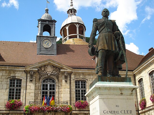
Lons-le-Saunier
- commune in Jura, France
Hiking in Lons-le-Saunier
Lons-le-Saunier, located in the Jura region of France, is a charming town known for its historical sites and natural beauty. It serves as an excellent base for hiking enthusiasts looking to explore the stunning Jura mountains, with a variety of trails that cater to different skill levels....
- Country:
- Postal Code: 39000
- Coordinates: 46° 40' 28" N, 5° 33' 14" E
- GPS tracks (wikiloc): [Link]
- AboveSeaLevel: 255 м m
- Area: 7.68 sq km
- Population: 17459
- Web site: [Link]


canton of Saint-Amour
- canton of France
Hiking in canton of Saint-Amour
The Canton of Saint-Amour, located in the Jura department of France, offers some beautiful and diverse hiking opportunities. Nestled in the Jura Mountains, this region is characterized by its stunning landscapes, rich biodiversity, and charming villages. Here are some highlights about hiking in this area:...
- Country:
- Capital: Saint-Amour
- Coordinates: 46° 26' 30" N, 5° 23' 20" E
- GPS tracks (wikiloc): [Link]
- Population: 13539


canton of Bletterans
- canton of France
Hiking in canton of Bletterans
The Canton of Bletterans, located in the Jura region of France, offers beautiful landscapes and a variety of hiking opportunities. The area is characterized by rolling hills, forests, and picturesque valleys, making it a great choice for nature lovers....
- Country:
- Capital: Bletterans
- Coordinates: 46° 44' 27" N, 5° 27' 11" E
- GPS tracks (wikiloc): [Link]
- Area: 457.42 sq km
- Population: 17055
canton of Nozeroy
- former canton of France (until March 2015)
Hiking in canton of Nozeroy
Canton de Nozeroy, located in the Jura department in eastern France, is a beautiful region known for its stunning landscapes, rich natural heritage, and charming villages. It's a fantastic destination for hiking enthusiasts, offering a variety of trails that cater to different skill levels. Here are some highlights:...

canton of Saint-Julien
- canton of France (until March 2015)
Hiking in canton of Saint-Julien
Canton de Saint-Julien, located in the Auvergne-Rhône-Alpes region of France, offers a beautiful landscape for hiking enthusiasts. This area is known for its picturesque scenery, charming villages, and diverse natural environments, making it a great destination for both novice and experienced hikers....
- Country:
- Capital: Saint-Julien
- Coordinates: 46° 23' 20" N, 5° 27' 17" E
- GPS tracks (wikiloc): [Link]