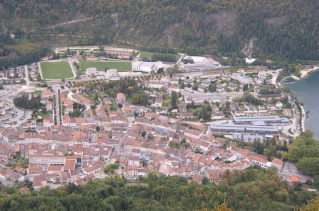
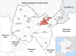
arrondissement of Nantua (arrondissement de Nantua)

- arrondissement of France
 Hiking in arrondissement of Nantua
The Arrondissement of Nantua, located in the Ain department of the Auvergne-Rhône-Alpes region in southeastern France, offers diverse hiking opportunities amidst stunning natural landscapes. Here are some highlights to consider when planning hikes in this area:
Natural Landscape
-
Lake Nantua: The lake is surrounded by beautiful trails with picturesque views. There are several paths suitable for all skill levels that allow hikers to appreciate the scenery.
-
Jurassic Mountains: The region is characterized by its dramatic cliffs and valleys, making it ideal for those who enjoy more challenging climbs and rugged terrain.
-
Forests and Wildlife: The area is rich in forests, which provide ample opportunities for hiking, birdwatching, and observing local wildlife.
Popular Hiking Trails
-
Tour du Lac de Nantua: This is a scenic hike that circles the lake and showcases the natural beauty of the surroundings. It is relatively easy and suitable for families.
-
Sentier des Cimes du Jura: A more challenging trail that takes you through the mountainous terrain offering panoramic views of the Jura mountains.
-
Le Mont Rond: For those seeking a bit of a challenge, this hike leads to one of the higher points in the region, providing breathtaking vistas.
Tips for Hiking in Nantua
-
Seasonal Considerations: Spring and fall are ideal for hiking due to mild temperatures and beautiful foliage. Summer can be warm, while winter activities may offer snowshoeing options.
-
Safety: Always inform someone of your hiking plans and expected return time. Wear appropriate footwear and bring water, snacks, and a first-aid kit.
-
Local Regulations: Respect nature and wildlife. Stay on marked trails and follow local guidelines to preserve the environment.
-
Navigation: It is beneficial to have a map or GPS device, as certain trails may not be well marked.
Conclusion
Nantua offers a unique blend of scenic beauty and adventure for hiking enthusiasts. Whether you're looking for a leisurely stroll around the lake or a challenging hike in the mountains, the Arrondissement of Nantua has something to offer for all levels of hikers. Enjoy your outdoor adventures!
- Country:

- Capital: Nantua
- Coordinates: 46° 10' 0" N, 5° 40' 0" E


- GPS tracks (wikiloc): [Link]
- Population: 93118
- Wikipedia en: wiki(en)
- Wikipedia: wiki(fr)
- Wikidata storage: Wikidata: Q682085
- Freebase ID: [/m/095hhx]
- GeoNames ID: Alt: [2990931]
- INSEE arrondissement code: [014]
- GNS Unique Feature ID: -1454498
Includes regions:

canton of Oyonnax-Nord
- canton of France (until March 2015)
Hiking in canton of Oyonnax-Nord
The Canton of Oyonnax-Nord, located in the Ain department of the Auvergne-Rhône-Alpes region in southeastern France, offers a variety of hiking opportunities characterized by stunning natural landscapes, rolling hills, and rich biodiversity. Here's an overview of what you can expect when hiking in this area:...
- Country:
- Capital: Oyonnax
- Coordinates: 46° 15' 22" N, 5° 39' 20" E
- GPS tracks (wikiloc): [Link]
- Population: 18326


canton of Izernore
- canton of France (until March 2015)
Hiking in canton of Izernore
The Canton of Izernore, located in the Ain department in the Auvergne-Rhône-Alpes region of France, offers some lovely hiking opportunities amidst beautiful natural landscapes. Here are some highlights and tips for hiking in this area:...


canton of Bellegarde-sur-Valserine
- canton of France
Hiking in canton of Bellegarde-sur-Valserine
The Canton of Bellegarde-sur-Valserine, located in the Ain department in the Auvergne-Rhône-Alpes region of France, offers a scenic and diverse landscape, making it an attractive destination for hiking enthusiasts. The area is characterized by its beautiful natural surroundings, including mountains, forests, and rivers, which provide a variety of hiking trails suitable for different skill levels....
- Country:
- Capital: Bellegarde-sur-Valserine
- Coordinates: 46° 6' 30" N, 5° 49' 36" E
- GPS tracks (wikiloc): [Link]
- Population: 21641

canton of Brénod
- canton of France (until March 2015)
Hiking in canton of Brénod
Hiking in the Canton of Brénod, located in the Ain department in the Auvergne-Rhône-Alpes region of France, offers a mix of stunning landscapes, rich wildlife, and diverse trails that cater to various experience levels. Here are some highlights and tips for hiking in this beautiful region:...
- Country:
- Capital: Brénod
- Coordinates: 46° 3' 41" N, 5° 36' 22" E
- GPS tracks (wikiloc): [Link]
- Area: 203.17 sq km
- Population: 3746
canton of Nantua
- canton of France
Hiking in canton of Nantua
The Canton of Nantua, located in the Ain department in the Auvergne-Rhône-Alpes region of France, is a beautiful destination for hiking enthusiasts. The area is characterized by its stunning landscapes, including mountains, lakes, and forests, offering a diverse range of hiking opportunities for all skill levels....
- Country:
- Capital: Nantua
- Coordinates: 46° 9' 7" N, 5° 36' 28" E
- GPS tracks (wikiloc): [Link]
- Area: 144.98 sq km
- Population: 21459
canton of Oyonnax-Sud
- canton of France
Hiking in canton of Oyonnax-Sud
Canton of Oyonnax-Sud, located in the Ain department in the Auvergne-Rhône-Alpes region of France, offers a variety of hiking opportunities that cater to different skill levels and preferences. The region is characterized by its stunning natural landscapes, including rolling hills, forests, rivers, and proximity to the Jura Mountains. Here are some key points to consider when hiking in this area:...
- Country:
- Capital: Oyonnax
- Coordinates: 46° 15' 22" N, 5° 39' 20" E
- GPS tracks (wikiloc): [Link]
- Population: 18831

canton of Poncin
- canton of France (until March 2015)
Hiking in canton of Poncin
The Canton of Poncin, located in the Ain department of the Auvergne-Rhône-Alpes region in France, offers a range of beautiful hiking opportunities amidst picturesque landscapes. Here’s what you should know about hiking in this area:...
- Country:
- Capital: Poncin
- Coordinates: 46° 5' 15" N, 5° 24' 25" E
- GPS tracks (wikiloc): [Link]
- Area: 107.43 sq km
- Population: 6041