Aumont-Aubrac (Aumont-Aubrac)

- former commune in Lozère, France
- Country:

- Postal Code: 48130
- Coordinates: 44° 43' 22" N, 3° 17' 2" E


- GPS tracks (wikiloc): [Link]
- Area: 26.53 sq km
- Population: 1063
- Wikipedia en: wiki(en)
- Wikipedia: wiki(fr)
- Wikidata storage: Wikidata: Q326270
- Wikipedia Commons Category: [Link]
- Freebase ID: [/m/02z0w56]
- Freebase ID: [/m/02z0w56]
- GeoNames ID: Alt: [6614090]
- GeoNames ID: Alt: [6614090]
- BnF ID: [152614165]
- BnF ID: [152614165]
- INSEE municipality code: 48009
- INSEE municipality code: 48009
Shares border with regions:


Fau-de-Peyre
- former commune in Lozère, France
- Country:
- Postal Code: 48130
- Coordinates: 44° 44' 54" N, 3° 13' 23" E
- GPS tracks (wikiloc): [Link]
- Area: 26.72 sq km
- Population: 186
- Web site: [Link]


Saint-Sauveur-de-Peyre
- former commune in Lozère, France
- Country:
- Postal Code: 48130
- Coordinates: 44° 39' 31" N, 3° 17' 14" E
- GPS tracks (wikiloc): [Link]
- Area: 27.61 sq km
- Population: 271
- Web site: [Link]


Javols
- former commune in Lozère, France
- Country:
- Postal Code: 48130
- Coordinates: 44° 41' 36" N, 3° 20' 32" E
- GPS tracks (wikiloc): [Link]
- Area: 31.21 sq km
- Population: 331
- Web site: [Link]
Les Bessons
- commune in Lozère, France
- Country:
- Postal Code: 48200
- Coordinates: 44° 46' 21" N, 3° 15' 12" E
- GPS tracks (wikiloc): [Link]
- Area: 23.49 sq km
- Population: 445


La Chaze-de-Peyre
- former commune in Lozère, France
- Country:
- Postal Code: 48130
- Coordinates: 44° 42' 10" N, 3° 15' 11" E
- GPS tracks (wikiloc): [Link]
- Area: 19.33 sq km
- Population: 308

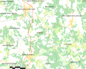
Rimeize
- commune in Lozère, France
- Country:
- Postal Code: 48200
- Coordinates: 44° 45' 54" N, 3° 19' 26" E
- GPS tracks (wikiloc): [Link]
- Area: 32.3 sq km
- Population: 577