Autrèche (Autrèche)

- commune in Indre-et-Loire, France
- Country:

- Postal Code: 37110
- Coordinates: 47° 31' 29" N, 0° 59' 46" E


- GPS tracks (wikiloc): [Link]
- Area: 20.72 sq km
- Population: 426
- Web site: http://www.autreche.fr
- Wikipedia en: wiki(en)
- Wikipedia: wiki(fr)
- Wikidata storage: Wikidata: Q736620
- Wikipedia Commons Category: [Link]
- Freebase ID: [/m/03nvcb3]
- GeoNames ID: Alt: [6614092]
- SIREN number: [213700099]
- INSEE municipality code: 37009
Shares border with regions:

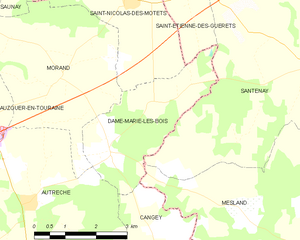
Dame-Marie-les-Bois
- commune in Indre-et-Loire, France
- Country:
- Postal Code: 37110
- Coordinates: 47° 32' 26" N, 1° 1' 55" E
- GPS tracks (wikiloc): [Link]
- Area: 8.91 sq km
- Population: 351
- Web site: [Link]


Cangey
- commune in Indre-et-Loire, France
- Country:
- Postal Code: 37530
- Coordinates: 47° 28' 4" N, 1° 3' 37" E
- GPS tracks (wikiloc): [Link]
- Area: 22.98 sq km
- Population: 1068
- Web site: [Link]

Montreuil-en-Touraine
- commune in Indre-et-Loire, France
- Country:
- Postal Code: 37530
- Coordinates: 47° 29' 13" N, 0° 56' 49" E
- GPS tracks (wikiloc): [Link]
- Area: 25.09 sq km
- Population: 836
- Web site: [Link]

Neuillé-le-Lierre
- commune in Indre-et-Loire, France
- Country:
- Postal Code: 37380
- Coordinates: 47° 30' 43" N, 0° 54' 36" E
- GPS tracks (wikiloc): [Link]
- Area: 16.63 sq km
- Population: 816


Saint-Ouen-les-Vignes
- commune in Indre-et-Loire, France
- Country:
- Postal Code: 37530
- Coordinates: 47° 28' 11" N, 0° 59' 40" E
- GPS tracks (wikiloc): [Link]
- Area: 18.55 sq km
- Population: 1016

Morand
- commune in Indre-et-Loire, France
- Country:
- Postal Code: 37110
- Coordinates: 47° 33' 45" N, 1° 0' 36" E
- GPS tracks (wikiloc): [Link]
- Area: 14.62 sq km
- Population: 358
- Web site: [Link]


Auzouer-en-Touraine
- commune in Indre-et-Loire, France
- Country:
- Postal Code: 37110
- Coordinates: 47° 32' 32" N, 0° 55' 11" E
- GPS tracks (wikiloc): [Link]
- Area: 34.05 sq km
- Population: 2185
- Web site: [Link]