Avrillé-les-Ponceaux (Avrillé-les-Ponceaux)

- commune in Indre-et-Loire, France
- Country:

- Postal Code: 37340
- Coordinates: 47° 23' 40" N, 0° 17' 11" E


- GPS tracks (wikiloc): [Link]
- Area: 32.8 sq km
- Population: 488
- Wikipedia en: wiki(en)
- Wikipedia: wiki(fr)
- Wikidata storage: Wikidata: Q519094
- Wikipedia Commons Category: [Link]
- Freebase ID: [/m/03nvcc4]
- GeoNames ID: Alt: [6448636]
- SIREN number: [213700131]
- BnF ID: [15257565w]
- INSEE municipality code: 37013
Shares border with regions:

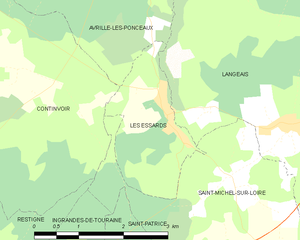
Les Essards
- former commune in Indre-et-Loire, France
- Country:
- Postal Code: 37130
- Coordinates: 47° 20' 43" N, 0° 18' 7" E
- GPS tracks (wikiloc): [Link]
- Area: 4.17 sq km
- Population: 160

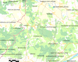
Continvoir
- commune in Indre-et-Loire, France
- Country:
- Postal Code: 37340
- Coordinates: 47° 23' 18" N, 0° 13' 14" E
- GPS tracks (wikiloc): [Link]
- Area: 41.19 sq km
- Population: 420
- Web site: [Link]


Cléré-les-Pins
- commune in Indre-et-Loire, France
- Country:
- Postal Code: 37340
- Coordinates: 47° 25' 31" N, 0° 23' 27" E
- GPS tracks (wikiloc): [Link]
- Area: 35.62 sq km
- Population: 1423
- Web site: [Link]


Langeais
- former commune in Indre-et-Loire, France
- Country:
- Postal Code: 37130
- Coordinates: 47° 19' 32" N, 0° 24' 22" E
- GPS tracks (wikiloc): [Link]
- Area: 60.38 sq km
- Population: 4248
- Web site: [Link]

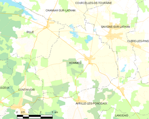
Hommes
- commune in Indre-et-Loire, France
- Country:
- Postal Code: 37340
- Coordinates: 47° 25' 33" N, 0° 17' 48" E
- GPS tracks (wikiloc): [Link]
- Area: 29.59 sq km
- Population: 882
- Web site: [Link]


Savigné-sur-Lathan
- commune in Indre-et-Loire, France
- Country:
- Postal Code: 37340
- Coordinates: 47° 26' 40" N, 0° 19' 13" E
- GPS tracks (wikiloc): [Link]
- Area: 17.61 sq km
- Population: 1365


Mazières-de-Touraine
- commune in Indre-et-Loire, France
- Country:
- Postal Code: 37130
- Coordinates: 47° 22' 59" N, 0° 25' 33" E
- GPS tracks (wikiloc): [Link]
- Area: 34.18 sq km
- Population: 1291
- Web site: [Link]