Ballabio (Ballabio)
.svg)
- Italian comune
 Hiking in Ballabio
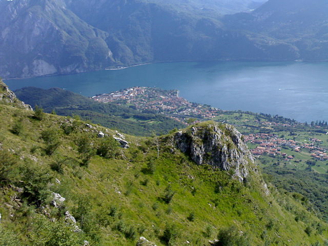
Ballabio, located in the Lombardy region of Italy, is a charming mountain village situated near the Lecco area and is an excellent destination for hiking enthusiasts. The surrounding mountains, particularly the Grigna range, offer a variety of trails suited for different skill levels, from easy walks to more challenging ascents.
Hiking Highlights in Ballabio:
-
Scenic Trails: The area boasts numerous trails with stunning views of Lake Como and the surrounding Alps. Popular routes include paths that ascend to panoramic viewpoints.
-
Grigna and Grignetta: These are two prominent mountains near Ballabio, with various trails leading to their summits. The ascent to the Grignetta offers breathtaking vistas and is a rewarding experience for those who are ready for a steep hike.
-
Flora and Fauna: Hikers can enjoy the rich biodiversity of the region, with various alpine plants and wildlife. Spring and summer are particularly beautiful times to explore the area.
-
Historical Sites: Along some trails, you'll also encounter historical structures, such as old shepherd huts and chapels, which add cultural value to your hike.
-
Trail Difficulty: Trails range from easy, suitable for families and beginners, to more strenuous climbs for experienced hikers. It’s advised to check the trail ratings and prepare accordingly.
-
Access: Ballabio is well-connected by public transport from Lecco, making it accessible for day trips. It's advisable to start early to enjoy a full day of hiking.
-
Local Amenities: After a day of hiking, you can enjoy local cuisine in Ballabio's restaurants, which typically offer traditional dishes of the region.
Safety Tips:
- Always check the weather before heading out.
- Wear appropriate hiking gear and bring sufficient water and snacks.
- Consider carrying a map or a GPS device, especially for less-trafficked paths.
- Let someone know your hiking plans and expected return time.
Guided Tours:
If you're unfamiliar with the area or prefer a structured experience, consider joining a guided hiking tour. Local guides can provide valuable insights into the landscape, flora, and history of Ballabio.
Overall, Ballabio is a fantastic spot for hiking, offering a mix of natural beauty and cultural richness, perfect for both casual walkers and serious hikers. Enjoy your adventures!
- Country:

- Postal Code: 23811
- Local Dialing Code: 0341
- Licence Plate Code: LC
- Coordinates: 45° 54' 0" N, 9° 25' 0" E


- GPS tracks (wikiloc): [Link]
- AboveSeaLevel: 661 м m
- Area: 15.04 sq km
- Population: 4052
- Web site: http://www.comune.ballabio.lc.it/
- Wikipedia en: wiki(en)
- Wikipedia: wiki(it)
- Wikidata storage: Wikidata: Q42790
- Wikipedia Commons Category: [Link]
- Freebase ID: [/m/0gr35r]
- GeoNames ID: Alt: [6539887]
- VIAF ID: Alt: [310606268]
- OSM relation ID: [46457]
- UN/LOCODE: [ITLLB]
- ISTAT ID: 097004
- Italian cadastre code: A594
Shares border with regions:


Pasturo
- Italian comune
Hiking in Pasturo
Pasturo is a charming village located in the Lombardy region of Italy, nestled within the beautiful landscapes of the Valsassina valley. It's a great destination for hiking enthusiasts, offering various trails that showcase the natural beauty of the area, including stunning views of mountains, lush forests, and local wildlife....
- Country:
- Postal Code: 23818
- Local Dialing Code: 0341
- Licence Plate Code: LC
- Coordinates: 45° 57' 0" N, 9° 26' 0" E
- GPS tracks (wikiloc): [Link]
- AboveSeaLevel: 641 м m
- Area: 21.78 sq km
- Population: 1993
- Web site: [Link]

Abbadia Lariana
- Italian comune in the Province of Lecco
Hiking in Abbadia Lariana
Abbadia Lariana is a charming village located on the eastern shore of Lake Como in Italy, and it offers a variety of hiking opportunities ranging from easy walks to more challenging trails. The region is characterized by its stunning natural scenery, including lush forests, rugged mountains, and beautiful lake views....
- Country:
- Postal Code: 23821
- Local Dialing Code: 0341
- Licence Plate Code: LC
- Coordinates: 45° 54' 0" N, 9° 20' 0" E
- GPS tracks (wikiloc): [Link]
- AboveSeaLevel: 204 м m
- Area: 16.67 sq km
- Population: 3216
- Web site: [Link]
Cremeno
- Italian comune
Hiking in Cremeno
Cremeno is a picturesque village located in the Lombardy region of northern Italy, nestled in the foothills of the Alps. It is an excellent destination for hiking enthusiasts due to its stunning natural beauty, diverse trails, and proximity to various alpine landscapes. Here are some highlights about hiking in and around Cremeno:...
- Country:
- Postal Code: 23814
- Local Dialing Code: 0341
- Licence Plate Code: LC
- Coordinates: 45° 56' 6" N, 9° 28' 16" E
- GPS tracks (wikiloc): [Link]
- AboveSeaLevel: 792 м m
- Area: 13.18 sq km
- Population: 1541
- Web site: [Link]


Mandello del Lario
- Italian comune
Hiking in Mandello del Lario
Mandello del Lario, located on the eastern shore of Lake Como in Italy, offers stunning landscapes, rich history, and a variety of hiking opportunities that cater to different levels of experience. Here are some highlights of hiking in this beautiful region:...
- Country:
- Postal Code: 23826
- Local Dialing Code: 0341
- Licence Plate Code: LC
- Coordinates: 45° 55' 0" N, 9° 19' 0" E
- GPS tracks (wikiloc): [Link]
- AboveSeaLevel: 200 м m
- Area: 43.33 sq km
- Population: 10313
- Web site: [Link]


Morterone
- Italian comune
Hiking in Morterone
Morterone, located in the Lombardy region of Italy, is a small mountain village nestled in the foothills of the Grigna massif. It's a fantastic destination for hikers looking to explore the natural beauty of the Italian Alps, offering a range of trails suitable for various skill levels....
- Country:
- Postal Code: 23811
- Local Dialing Code: 0341
- Licence Plate Code: LC
- Coordinates: 45° 52' 26" N, 9° 28' 58" E
- GPS tracks (wikiloc): [Link]
- AboveSeaLevel: 1070 м m
- Area: 13.71 sq km
- Population: 35
- Web site: [Link]


Lecco
- Italian comune
Hiking in Lecco
Lecco, located in the Lombardy region of northern Italy, is a fantastic destination for hiking enthusiasts. Nestled at the southeastern tip of Lake Como, it offers stunning natural landscapes, diverse trails, and breathtaking views of the surrounding mountains, including the Grigna and Resegone ranges....
- Country:
- Postal Code: 23900
- Local Dialing Code: 0341
- Licence Plate Code: LC
- Coordinates: 45° 51' 0" N, 9° 24' 0" E
- GPS tracks (wikiloc): [Link]
- AboveSeaLevel: 214 м m
- Area: 45.14 sq km
- Population: 48177
- Web site: [Link]