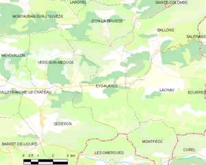
Ballons (Ballons)
- commune in Drôme, France
Hiking in the Ballons des Vosges Regional Nature Park, located in northeastern France, offers a diverse range of trails and stunning landscapes. The park is characterized by its rolling hills, mountainous terrain, and dense forests, making it a fantastic destination for both novice and experienced hikers.
Key Highlights:
-
Scenic Views: The park features breathtaking views from various vantage points, including the Ballon d'Alsace, which is one of the highest points in the Vosges mountains. On a clear day, you can see the Black Forest in Germany and the Alps in the distance.
-
Diverse Trails: There are numerous well-marked hiking trails, ranging from easy walks to challenging hikes. Popular routes include the Circuit des Crêtes which follows the ridge of the Vosges, and the trails around Lake Gérardmer and Lac de Longemer, where you can enjoy both mountain and lakeside views.
-
Flora and Fauna: The region is rich in biodiversity. As you hike, you'll encounter a variety of plants and wildlife, including rare species, and ancient forests that offer respite and beauty.
-
Cultural Sites: Along the trails, hikers can explore historical sites, including old forts and chapels, as well as traditional Alsatian villages where you can experience local culture and cuisine.
-
Seasonal Hiking: Each season offers a unique experience. Spring and summer bring vibrant flowers and lush forests, while autumn showcases stunning fall colors. Winter hiking and snowshoeing are popular as well, transforming the area into a winter wonderland.
Preparation Tips:
-
Gear: Wear sturdy hiking boots, and dress in layers, as the weather can change quickly in the mountains. Always carry a map, water, snacks, and possibly trekking poles for steep trails.
-
Safety: Inform someone of your hiking plans, especially if venturing into remote areas. It’s advisable to check local weather conditions before heading out.
-
Trail Maps: Make use of local maps and guides, which provide detailed information about the trails, level of difficulty, and points of interest.
Conclusion:
Hiking in Ballons des Vosges provides an excellent opportunity to enjoy nature and engage in outdoor activities. Whether you're looking for a leisurely stroll or a challenging trek, the Vosges offers something for everyone. Enjoy your adventure!
- Country:

- Postal Code: 26560
- Coordinates: 44° 15' 21" N, 5° 38' 39" E


- GPS tracks (wikiloc): [Link]
- Area: 17.23 sq km
- Population: 83
- Wikipedia en: wiki(en)
- Wikipedia: wiki(fr)
- Wikidata storage: Wikidata: Q539360
- Wikipedia Commons Category: [Link]
- Freebase ID: [/m/0f9bp1]
- GeoNames ID: Alt: [6612196]
- SIREN number: [212600225]
- BnF ID: [15252883f]
- PACTOLS thesaurus ID: [pcrtVVVtGzipFJ]
- INSEE municipality code: 26022
Shares border with regions:

Barret-sur-Méouge
- commune in Hautes-Alpes, France
Barret-sur-Méouge is a charming village located in the Drôme department in southeastern France, surrounded by stunning natural landscapes that make it a great destination for hiking enthusiasts. The area is characterized by its mountainous terrain, lush greenery, and the picturesque Méouge Valley, which offers numerous hiking opportunities suitable for various skill levels....
- Country:

- Postal Code: 05300
- Coordinates: 44° 15' 45" N, 5° 44' 1" E


- GPS tracks (wikiloc): [Link]
- Area: 26.72 sq km
- Population: 225

Salérans
- commune in Hautes-Alpes, France
Salérans is a small village located in the Hautes-Alpes region of southeastern France, known for its stunning natural scenery and outdoor activities, including hiking. It is situated near the Écrins National Park and offers access to beautiful landscapes, rugged mountains, and a sense of tranquility often found in rural areas....
- Country:

- Postal Code: 05300
- Coordinates: 44° 14' 35" N, 5° 42' 17" E


- GPS tracks (wikiloc): [Link]
- Area: 13.9 sq km
- Population: 94

Sainte-Colombe
- commune in Hautes-Alpes, France
Sainte-Colombe, situated in the Hautes-Alpes region of France, is known for its stunning natural landscapes and diverse hiking trails, making it a great destination for outdoor enthusiasts. Here are some highlights and tips for hiking in the area:...
- Country:

- Postal Code: 05700
- Coordinates: 44° 17' 5" N, 5° 40' 9" E


- GPS tracks (wikiloc): [Link]
- AboveSeaLevel: 920 м m
- Area: 17.18 sq km
- Population: 58


Izon-la-Bruisse
- commune in Drôme, France
Izon-la-Bruisse is a beautiful destination located in the French Alps, known for its stunning landscapes, diverse flora and fauna, and well-marked hiking trails. Here are some highlights and tips for hiking in this region:...
- Country:

- Postal Code: 26560
- Coordinates: 44° 15' 20" N, 5° 35' 36" E


- GPS tracks (wikiloc): [Link]
- Area: 14.65 sq km
- Population: 9


Eygalayes
- commune in Drôme, France
Eygaliers is a picturesque village in the Drôme department of southeastern France, nestled in the beautiful landscape of the Vercors Regional Natural Park. It offers a variety of hiking opportunities that cater to all levels of experience. Here’s a general overview of hiking in the Eygaliers area:...
- Country:

- Postal Code: 26560
- Coordinates: 44° 14' 21" N, 5° 36' 28" E


- GPS tracks (wikiloc): [Link]
- Area: 17.97 sq km
- Population: 76
- Web site: [Link]


Lachau
- commune in Drôme, France
Lachau is a picturesque region located in southeastern France, known for its stunning landscapes, diverse flora and fauna, and well-maintained hiking trails. Here are some key points to consider if you're planning to hike in Lachau:...
- Country:

- Postal Code: 26560
- Coordinates: 44° 13' 56" N, 5° 38' 16" E


- GPS tracks (wikiloc): [Link]
- Area: 25.78 sq km
- Population: 222

