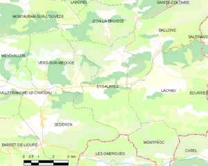
Lachau (Lachau)

- commune in Drôme, France
 Hiking in Lachau
Lachau is a picturesque region located in southeastern France, known for its stunning landscapes, diverse flora and fauna, and well-maintained hiking trails. Here are some key points to consider if you're planning to hike in Lachau:
Trails and Routes
-
Variety of Trails: Lachau offers a range of trails for hikers of all skill levels, from easy walks to challenging treks. You can find paths that wind through forests, along rivers, and up to viewpoints with breathtaking panoramas.
-
Scenic Views: Many trails feature stunning vistas of the surrounding mountains, valleys, and natural landscapes. Keep your camera handy, as there are numerous photo opportunities along the way.
-
Trail Markings: The trails are generally well-marked with signs indicating directions and difficulty levels, making it easy for hikers to navigate the area.
Best Time to Hike
- Spring and Fall: The ideal times to hike in Lachau are during the spring and fall months. In spring, you'll experience mild weather and blooming wildflowers. Fall offers stunning autumn foliage and cooler temperatures.
- Summer: While summer can be hot, mornings and evenings are usually pleasant, making for enjoyable hiking conditions if you start early or go in the later afternoon.
Preparation
-
Gear Up: Make sure to wear appropriate hiking footwear, carry plenty of water, and have snacks for energy. Depending on the season, dress in layers to accommodate changing temperatures.
-
Map and Navigation: While trails are usually well-marked, having a map or GPS device can be helpful for unfamiliar routes. Download maps or use hiking apps where available.
-
Safety: Always let someone know your hiking plans, especially if you’re going solo. Carry a basic first-aid kit and know the location of the nearest emergency services.
Features of the Region
-
Flora and Fauna: As you hike, you may encounter diverse plant life and wildlife. Keep an eye out for local species, and respect the natural environment by staying on designated trails.
-
Cultural Sites: Some trails may pass by historical or cultural sites, giving you a glimpse into the heritage of the region.
Local Amenities
-
Accommodations: There are various accommodation options ranging from camping areas to charming local inns or lodges. Plan your stay in advance, especially during peak hiking seasons.
-
Guided Tours: If you prefer a more structured experience, consider joining a guided hike. Local guides can provide insight into the area's ecology, history, and hidden gems.
In summary, hiking in Lachau can offer a rewarding experience with its beautiful landscapes and vibrant nature. Always prioritize safety and respect the environment, and you’re sure to enjoy your adventure in this lovely region!
- Country:

- Postal Code: 26560
- Coordinates: 44° 13' 56" N, 5° 38' 16" E


- GPS tracks (wikiloc): [Link]
- Area: 25.78 sq km
- Population: 222
- Wikipedia en: wiki(en)
- Wikipedia: wiki(fr)
- Wikidata storage: Wikidata: Q970167
- Wikipedia Commons Category: [Link]
- Freebase ID: [/m/03mhhps]
- GeoNames ID: Alt: [6612405]
- SIREN number: [212601546]
- BnF ID: [152530150]
- Pleiades ID: [148104]
- INSEE municipality code: 26154
Shares border with regions:


Montfroc
- commune in Drôme, France
Hiking in Montfroc
Montfroc, located in the Provence-Alpes-Côte d'Azur region of France, offers beautiful hiking opportunities amidst stunning natural landscapes. Here are some highlights and tips for hiking in and around Montfroc:...
- Country:
- Postal Code: 26560
- Coordinates: 44° 10' 29" N, 5° 38' 20" E
- GPS tracks (wikiloc): [Link]
- Area: 14.76 sq km
- Population: 77

Curel
- commune in Alpes-de-Haute-Provence, France
Hiking in Curel
Curel, located in the Alpes-de-Haute-Provence region of France, offers a serene and picturesque hiking experience. This area is characterized by its beautiful landscapes, rolling hills, and unique geological features, making it a great destination for hikers of all levels....
- Country:
- Postal Code: 04200
- Coordinates: 44° 10' 37" N, 5° 39' 42" E
- GPS tracks (wikiloc): [Link]
- Area: 10.45 sq km
- Population: 60
- Web site: [Link]

Salérans
- commune in Hautes-Alpes, France
Hiking in Salérans
Salérans is a small village located in the Hautes-Alpes region of southeastern France, known for its stunning natural scenery and outdoor activities, including hiking. It is situated near the Écrins National Park and offers access to beautiful landscapes, rugged mountains, and a sense of tranquility often found in rural areas....
- Country:
- Postal Code: 05300
- Coordinates: 44° 14' 35" N, 5° 42' 17" E
- GPS tracks (wikiloc): [Link]
- Area: 13.9 sq km
- Population: 94

Éourres
- commune in Hautes-Alpes, France
Hiking in Éourres
Éourres is a charming village located in the Hautes-Alpes region of France, near the stunning Dévoluy mountain range. It’s an ideal destination for hiking enthusiasts, offering various trails that cater to different skill levels and showcase the area’s natural beauty....
- Country:
- Postal Code: 26560
- Coordinates: 44° 12' 44" N, 5° 41' 57" E
- GPS tracks (wikiloc): [Link]
- Area: 26.47 sq km
- Population: 128
- Web site: [Link]


Ballons
- commune in Drôme, France
Hiking in Ballons
Hiking in the Ballons des Vosges Regional Nature Park, located in northeastern France, offers a diverse range of trails and stunning landscapes. The park is characterized by its rolling hills, mountainous terrain, and dense forests, making it a fantastic destination for both novice and experienced hikers....
- Country:
- Postal Code: 26560
- Coordinates: 44° 15' 21" N, 5° 38' 39" E
- GPS tracks (wikiloc): [Link]
- Area: 17.23 sq km
- Population: 83

Eygalayes
- commune in Drôme, France
Hiking in Eygalayes
Eygaliers is a picturesque village in the Drôme department of southeastern France, nestled in the beautiful landscape of the Vercors Regional Natural Park. It offers a variety of hiking opportunities that cater to all levels of experience. Here’s a general overview of hiking in the Eygaliers area:...
- Country:
- Postal Code: 26560
- Coordinates: 44° 14' 21" N, 5° 36' 28" E
- GPS tracks (wikiloc): [Link]
- Area: 17.97 sq km
- Population: 76
- Web site: [Link]