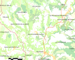
Banassac (Banassac)
- former commune in Lozère, France
- Country:

- Postal Code: 48500
- Coordinates: 44° 26' 10" N, 3° 12' 0" E


- GPS tracks (wikiloc): [Link]
- Area: 17.41 sq km
- Population: 872
- Web site: http://www.banassac.fr
- Wikipedia en: wiki(en)
- Wikipedia: wiki(fr)
- Wikidata storage: Wikidata: Q381323
- Wikipedia Commons Category: [Link]
- Freebase ID: [/m/02w96fc]
- Freebase ID: [/m/02w96fc]
- GeoNames ID: Alt: [6449337]
- GeoNames ID: Alt: [6449337]
- BnF ID: [15261424s]
- BnF ID: [15261424s]
- VIAF ID: Alt: [245706954]
- VIAF ID: Alt: [245706954]
- Digital Atlas of the Roman Empire ID: [12226]
- Digital Atlas of the Roman Empire ID: [12226]
- Pleiades ID: [138214]
- Pleiades ID: [138214]
- INSEE municipality code: 48017
- INSEE municipality code: 48017
Shares border with regions:
Saint-Pierre-de-Nogaret
- commune in Lozère, France
- Country:

- Postal Code: 48340
- Coordinates: 44° 27' 41" N, 3° 8' 23" E


- GPS tracks (wikiloc): [Link]
- Area: 16.44 sq km
- Population: 179


Canilhac
- former commune in Lozère, France
- Country:

- Postal Code: 48500
- Coordinates: 44° 25' 25" N, 3° 9' 1" E


- GPS tracks (wikiloc): [Link]
- Area: 7.27 sq km
- Population: 164


La Canourgue
- commune in Lozère, France
- Country:

- Postal Code: 48500
- Coordinates: 44° 25' 58" N, 3° 12' 53" E


- GPS tracks (wikiloc): [Link]
- Area: 104.29 sq km
- Population: 2090
- Web site: [Link]


Saint-Germain-du-Teil
- commune in Lozère, France
- Country:

- Postal Code: 48340
- Coordinates: 44° 28' 41" N, 3° 10' 20" E


- GPS tracks (wikiloc): [Link]
- Area: 22.58 sq km
- Population: 863
La Tieule
- commune in Lozère, France
- Country:

- Postal Code: 48500
- Coordinates: 44° 23' 2" N, 3° 9' 23" E


- GPS tracks (wikiloc): [Link]
- Area: 24 sq km
- Population: 88


Saint-Saturnin
- commune in Lozère, France
- Country:

- Postal Code: 48500
- Coordinates: 44° 24' 41" N, 3° 11' 18" E


- GPS tracks (wikiloc): [Link]
- Area: 9.14 sq km
- Population: 63
