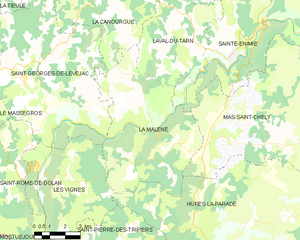
La Canourgue (La Canourgue)

- commune in Lozère, France
- Country:

- Postal Code: 48500
- Coordinates: 44° 25' 58" N, 3° 12' 53" E


- GPS tracks (wikiloc): [Link]
- Area: 104.29 sq km
- Population: 2090
- Web site: http://www.la-canourgue.com
- Wikipedia en: wiki(en)
- Wikipedia: wiki(fr)
- Wikidata storage: Wikidata: Q473333
- Wikipedia Commons Category: [Link]
- Freebase ID: [/m/02w974d]
- Freebase ID: [/m/02w974d]
- GeoNames ID: Alt: [6456938]
- GeoNames ID: Alt: [6456938]
- SIREN number: [214800344]
- SIREN number: [214800344]
- BnF ID: [15261441c]
- BnF ID: [15261441c]
- VIAF ID: Alt: [240074653]
- VIAF ID: Alt: [240074653]
- GND ID: Alt: [4448727-7]
- GND ID: Alt: [4448727-7]
- WOEID: [597243]
- WOEID: [597243]
- INSEE municipality code: 48034
- INSEE municipality code: 48034
Shares border with regions:

La Malène
- commune in Lozère, France
- Country:
- Postal Code: 48210
- Coordinates: 44° 18' 9" N, 3° 19' 13" E
- GPS tracks (wikiloc): [Link]
- Area: 40.68 sq km
- Population: 148
- Web site: [Link]

Le Monastier-Pin-Moriès
- former commune in Lozère, France
- Country:
- Postal Code: 48100
- Coordinates: 44° 30' 53" N, 3° 15' 16" E
- GPS tracks (wikiloc): [Link]
- AboveSeaLevel: 610 м m
- Area: 19.3 sq km
- Population: 976
- Web site: [Link]


Banassac
- former commune in Lozère, France
- Country:
- Postal Code: 48500
- Coordinates: 44° 26' 10" N, 3° 12' 0" E
- GPS tracks (wikiloc): [Link]
- Area: 17.41 sq km
- Population: 872
- Web site: [Link]


Saint-Georges-de-Lévéjac
- former commune in Lozère, France
- Country:
- Postal Code: 48500
- Coordinates: 44° 19' 9" N, 3° 13' 51" E
- GPS tracks (wikiloc): [Link]
- Area: 56.26 sq km
- Population: 250
- Web site: [Link]


Chanac
- commune in Lozère, France
- Country:
- Postal Code: 48230
- Coordinates: 44° 27' 59" N, 3° 20' 35" E
- GPS tracks (wikiloc): [Link]
- Area: 71.14 sq km
- Population: 1460
- Web site: [Link]

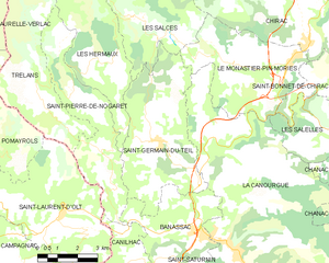
Saint-Germain-du-Teil
- commune in Lozère, France
- Country:
- Postal Code: 48340
- Coordinates: 44° 28' 41" N, 3° 10' 20" E
- GPS tracks (wikiloc): [Link]
- Area: 22.58 sq km
- Population: 863

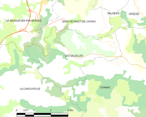
Les Salelles
- commune in Lozère, France
- Country:
- Postal Code: 48230
- Coordinates: 44° 28' 53" N, 3° 16' 46" E
- GPS tracks (wikiloc): [Link]
- Area: 10.62 sq km
- Population: 167
La Tieule
- commune in Lozère, France
- Country:
- Postal Code: 48500
- Coordinates: 44° 23' 2" N, 3° 9' 23" E
- GPS tracks (wikiloc): [Link]
- Area: 24 sq km
- Population: 88


Saint-Saturnin
- commune in Lozère, France
- Country:
- Postal Code: 48500
- Coordinates: 44° 24' 41" N, 3° 11' 18" E
- GPS tracks (wikiloc): [Link]
- Area: 9.14 sq km
- Population: 63


Laval-du-Tarn
- commune in Lozère, France
- Country:
- Postal Code: 48500
- Coordinates: 44° 21' 15" N, 3° 21' 12" E
- GPS tracks (wikiloc): [Link]
- Area: 36.85 sq km
- Population: 102