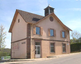
Banvillars (Banvillars)

- commune in Territoire de Belfort, France
 Hiking in Banvillars
Banvillars is a small village located in the Bourgogne-Franche-Comté region of France, known for its picturesque countryside and natural beauty. While it may not be as famous as some of the larger hiking destinations, it offers a unique and charming experience for hikers looking to explore the serene landscapes of eastern France.
Hiking Trails
- Local Paths: The surrounding area features a variety of hiking trails, ranging from easy walks to more challenging routes. You can find well-marked paths that take you through forests, hills, and farmlands, providing a wonderful opportunity to experience the local flora and fauna.
- Nearby Natural Sites: Just a short distance from Banvillars, you can explore larger natural parks and reserves, such as the Parc Naturel Régional du Doubs, which has numerous trails and breathtaking views.
Scenic Highlights
- Countryside Views: The rolling hills and lush greenery of the region create a picturesque setting for hikers. You may encounter vineyards, charming farms, and quaint villages along your route.
- Wildlife Spotting: The area is rich in biodiversity. Keep an eye out for various bird species, deer, and other wildlife.
- Cultural Sites: Some trails may lead you past historical sites, including old chapels or remnants of ancient structures, giving you a glimpse into the region's history.
Tips for Hiking in Banvillars
- Preparation: Make sure to wear appropriate footwear and dress in layers, as the weather can change. Carry enough water and snacks.
- Navigation: While many trails are marked, having a map or a hiking app can be helpful. It’s also a good idea to let someone know your hiking plans.
- Local Resources: Check with local tourism offices for maps, trail information, and any guided hike opportunities.
Best Time to Hike
The best time to hike in Banvillars is during the spring and fall, when the weather is mild, and the scenery is especially beautiful with blooming flowers or colorful autumn leaves.
Whether you are a seasoned hiker or a casual walker, the peaceful environment of Banvillars offers a delightful adventure in nature. Happy hiking!
- Country:

- Postal Code: 90800
- Coordinates: 47° 35' 32" N, 6° 48' 53" E


- GPS tracks (wikiloc): [Link]
- Area: 4.67 sq km
- Population: 283
- Web site: http://www.banvillars.com
- Wikipedia en: wiki(en)
- Wikipedia: wiki(fr)
- Wikidata storage: Wikidata: Q674424
- Wikipedia Commons Category: [Link]
- Freebase ID: [/m/03mh906]
- Freebase ID: [/m/03mh906]
- Freebase ID: [/m/03mh906]
- GeoNames ID: Alt: [6452601]
- GeoNames ID: Alt: [6452601]
- GeoNames ID: Alt: [6452601]
- SIREN number: [219000072]
- SIREN number: [219000072]
- SIREN number: [219000072]
- BnF ID: [152799489]
- BnF ID: [152799489]
- BnF ID: [152799489]
- INSEE municipality code: 90007
- INSEE municipality code: 90007
- INSEE municipality code: 90007
Shares border with regions:


Échenans-sous-Mont-Vaudois
- commune in Haute-Saône, France
Hiking in Échenans-sous-Mont-Vaudois
Échenans-sous-Mont-Vaudois, located in the Bourgogne-Franche-Comté region of France, offers a serene and scenic environment for hiking enthusiasts. While it may not be one of the most prominent hiking destinations, it provides a peaceful escape into nature, particularly for those who enjoy exploring less crowded trails....
- Country:
- Postal Code: 70400
- Coordinates: 47° 36' 10" N, 6° 46' 18" E
- GPS tracks (wikiloc): [Link]
- AboveSeaLevel: 381 м m
- Area: 5.44 sq km
- Population: 499


Dorans
- commune in Territoire de Belfort, France
Hiking in Dorans
Dorans is not a well-known hiking destination, and there may be limited information readily available. However, I can provide some general tips and advice for hiking in lesser-known areas, which could be useful if you're considering hiking in a location named Dorans or a similar locality....
- Country:
- Postal Code: 90400
- Coordinates: 47° 35' 16" N, 6° 50' 19" E
- GPS tracks (wikiloc): [Link]
- Area: 3.77 sq km
- Population: 718

Argiésans
- commune in Territoire de Belfort, France
Hiking in Argiésans
Argiésans is a picturesque region known for its stunning natural landscapes, making it an excellent destination for hiking enthusiasts. Nestled in the heart of the Pyrenees, this area offers a variety of trails that cater to different skill levels, from gentle walks to challenging climbs....
- Country:
- Postal Code: 90800
- Coordinates: 47° 36' 14" N, 6° 49' 22" E
- GPS tracks (wikiloc): [Link]
- Area: 2.73 sq km
- Population: 433

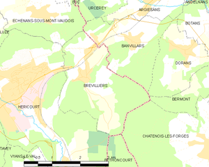
Brevilliers
- commune in Haute-Saône, France
Hiking in Brevilliers
Brevilliers is a small village located in the Doubs department of the Bourgogne-Franche-Comté region in eastern France. While it is not a well-known hiking destination, the surrounding area offers beautiful landscapes and trails that can be explored by hiking enthusiasts....
- Country:
- Postal Code: 70400
- Coordinates: 47° 34' 54" N, 6° 47' 32" E
- GPS tracks (wikiloc): [Link]
- Area: 6.47 sq km
- Population: 619


Urcerey
- commune in Territoire de Belfort, France
Hiking in Urcerey
Urcerey is not a widely recognized hiking destination, so it might refer to a specific area with local interest or a less-known name. However, if you meant a popular hiking area or trail with a name similar to Urcerey, please clarify....
- Country:
- Postal Code: 90800
- Coordinates: 47° 36' 29" N, 6° 48' 33" E
- GPS tracks (wikiloc): [Link]
- Area: 3.39 sq km
- Population: 215