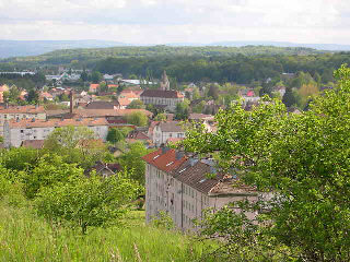
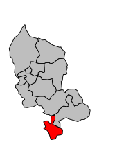
arrondissement of Belfort (arrondissement de Belfort)

- arrondissement of France
 Hiking in arrondissement of Belfort
The Arrondissement of Belfort, located in the Bourgogne-Franche-Comté region of eastern France, offers a variety of hiking opportunities set against a backdrop of stunning natural landscapes. Here are some highlights and tips for hiking in this area:
Natural Features
-
Voges Mountains: The northern edge of the arrondissement features the foothills of the Vosges Mountains, characterized by rolling hills and diverse ecosystems. You'll find a mix of deciduous and coniferous forests, as well as rivers and streams.
-
Ballon d'Alsace: Nearby, this regional park offers incredible panoramic views and a variety of trails for different skill levels. The area is rich in biodiversity, making it a great spot for both hiking and birdwatching.
-
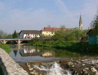
River Doubs: The Doubs river runs through the region, providing opportunities for scenic trails following its banks. The river landscape is both beautiful and serene.
Popular Hiking Trails
-
Markstein to Hohneck: A more challenging hike that allows you to experience higher elevations and stunning views over the region and beyond.
-
Sentier des Doubs: Following the Doubs river, this trail is perfect for those interested in a more level, pleasant hike with scenic views of the water and surrounding nature.
-
Les Crêtes: This trail offers a mix of hiking and history, as it traverses areas significant to both World War I and World War II.
Practical Tips
-
Trail Maps: Be sure to grab a map of the local hiking trails, as well-marked paths are essential for safe navigation, especially in more remote areas.
-
Weather Conditions: The weather can be variable, so always check forecasts before heading out and dress accordingly in layers to be prepared for changes.
-
Safety: Carry a first-aid kit, plenty of water, and snacks. Let someone know your hiking plans in case of emergencies.
-
Local Regulations: Respect the environment by sticking to marked trails, and if you’re hiking in protected areas, be aware of any regulations regarding wildlife and plant life.
Conclusion
Hiking in the Arrondissement of Belfort offers a rewarding experience with a mix of natural beauty and cultural history. Whether you're looking for a leisurely stroll or a more challenging trek, the area's diverse landscapes provide something for every hiker. Enjoy your adventures!
- Country:

- Capital: Belfort
- Coordinates: 47° 40' 0" N, 6° 55' 0" E


- GPS tracks (wikiloc): [Link]
- Area: 609 sq km
- Population: 144483
- Wikipedia en: wiki(en)
- Wikipedia: wiki(fr)
- Wikidata storage: Wikidata: Q669222
- Freebase ID: [/m/095bw_]
- GeoNames ID: Alt: [3033790]
- INSEE arrondissement code: [901]
- GNS Unique Feature ID: -1411529
Includes regions:
canton of Belfort-Est
- canton of France (until March 2015)
Hiking in canton of Belfort-Est
Canton de Belfort-Est, located in the Bourgogne-Franche-Comté region of France, offers a variety of hiking opportunities characterized by its diverse landscapes, including forests, hills, and picturesque villages. Here’s what you need to know if you’re planning to hike in this area:...
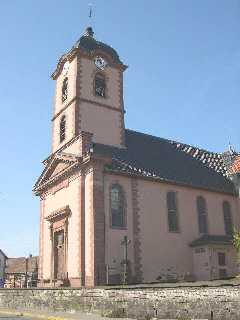

canton of Châtenois-les-Forges
- canton of France
Hiking in canton of Châtenois-les-Forges
Canton of Châtenois-les-Forges, located in the Vosges department in the Grand Est region of France, offers beautiful hiking opportunities with a mix of natural beauty and cultural heritage. Here are some key highlights for hiking in this area:...
- Country:
- Capital: Châtenois-les-Forges
- Coordinates: 47° 35' 33" N, 6° 49' 57" E
- GPS tracks (wikiloc): [Link]
- Population: 14550
Canton of Danjoutin
- canton of France (until March 2015)
Hiking in Canton of Danjoutin
Canton de Danjoutin, located in the Bourgogne-Franche-Comté region of France, offers a variety of outdoor recreational opportunities, including hiking. The area is characterized by its picturesque landscapes, ranging from rolling hills to forests and rivers....

canton of Fontaine
- canton of France (until March 2015)
Hiking in canton of Fontaine
Canton de Fontaine, located in the Auvergne-Rhône-Alpes region of France, is a beautiful area for hiking, filled with diverse landscapes and rich natural beauty. This region is known for its picturesque villages, rolling hills, and the stunning backdrop of the French Alps....

canton of Beaucourt
- canton of France (until March 2015)
Hiking in canton of Beaucourt
Canton de Beaucourt, located in the Bourgogne-Franche-Comté region of eastern France, offers a variety of hiking opportunities in a scenic environment. This area is characterized by its rolling hills, dense forests, and charming villages, making it a great destination for outdoor enthusiasts....

canton of Offemont
- canton of France (until March 2015)
Hiking in canton of Offemont
Canton d'Offemont, located in the Bourgogne-Franche-Comté region of France, offers a variety of hiking opportunities that are ideal for both beginners and experienced hikers. The region is characterized by its picturesque landscapes, including rolling hills, forests, and charming villages, making it a scenic backdrop for outdoor activities....


canton of Delle
- canton of France
Hiking in canton of Delle
The Canton of Delle, located in the Bourgogne-Franche-Comté region of France, offers a variety of hiking opportunities that cater to different skill levels. The area is known for its beautiful landscapes, including rolling hills, forests, and charming villages....
- Country:
- Capital: Delle
- Coordinates: 47° 30' 45" N, 7° 2' 59" E
- GPS tracks (wikiloc): [Link]
- Population: 17532
canton of Belfort-Centre
- canton of France (until March 2015)
Hiking in canton of Belfort-Centre
Canton de Belfort-Centre, located in the northeastern part of France, is a great destination for hiking enthusiasts. The region offers diverse landscapes, including rolling hills, forests, and the stunning Vosges mountains, making it perfect for various hiking experiences....
canton of Belfort-Sud
- canton of France (until March 2015)
Hiking in canton of Belfort-Sud
Canton de Belfort-Sud, located in the Bourgogne-Franche-Comté region of France, offers a variety of scenic hiking opportunities, perfect for those who appreciate natural beauty and diverse landscapes. The region is characterized by its rolling hills, lush forests, and stunning views of the Vosges mountains. Here are some highlights for hikers in this area:...

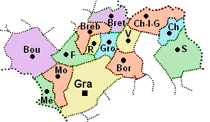
canton of Grandvillars
- canton of France
Hiking in canton of Grandvillars
The Canton of Grandvillars, located in the Bourgogne-Franche-Comté region of France, is known for its beautiful landscapes, rich history, and extensive hiking trails. While not as famous as some other hiking destinations in France, it offers a variety of outdoor experiences that cater to hikers of all skill levels....
- Country:
- Capital: Grandvillars
- Coordinates: 47° 34' 5" N, 6° 59' 26" E
- GPS tracks (wikiloc): [Link]
- Population: 17084
canton of Belfort-Ouest
- canton of France (until March 2015)
Hiking in canton of Belfort-Ouest
Canton de Belfort-Ouest, located in the Bourgogne-Franche-Comté region of France, offers a beautiful landscape suited for hiking enthusiasts. The area is characterized by its rolling hills, dense forests, and scenic views, making it an attractive destination for outdoor activities....

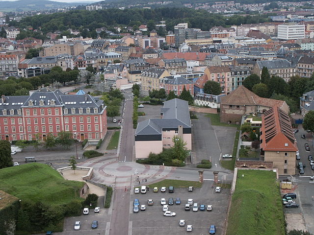
Belfort
- commune in Territoire de Belfort, France
Hiking in Belfort
Belfort, a city in northeastern France, is known for its scenic landscapes and historical significance, particularly the impressive citadel built by Vauban. When it comes to hiking, the area surrounding Belfort offers a variety of trails that cater to different skill levels and preferences, showcasing the natural beauty of the region....
- Country:
- Postal Code: 90000
- Coordinates: 47° 38' 15" N, 6° 51' 46" E
- GPS tracks (wikiloc): [Link]
- AboveSeaLevel: 358 м m
- Area: 17.1 sq km
- Population: 49519
- Web site: [Link]


canton of Giromagny
- canton of France
- Country:
- Capital: Giromagny
- Coordinates: 47° 43' 38" N, 6° 50' 5" E
- GPS tracks (wikiloc): [Link]
- Population: 15405

canton of Valdoie
- canton of France
Hiking in canton of Valdoie
The Canton of Valdoie, located in the region of Bourgogne-Franche-Comté in eastern France, offers a picturesque backdrop for hiking enthusiasts. Nestled near the Doubs River and surrounded by rolling hills and diverse landscapes, it features a mix of natural beauty, charming villages, and historical sites that make it an attractive destination for hikers....
- Country:
- Capital: Valdoie
- Coordinates: 47° 39' 3" N, 6° 49' 45" E
- GPS tracks (wikiloc): [Link]
- Population: 15483
canton of Belfort-Nord
- canton of France (until March 2015)
Hiking in canton of Belfort-Nord
Canton de Belfort-Nord, located in the Bourgogne-Franche-Comté region of France, offers a diverse range of hiking opportunities amidst beautiful natural landscapes. Here are some key highlights and tips for hiking in this area:...

canton of Rougemont-le-Château
- canton of France (until March 2015)
- Country:
- Capital: Rougemont-le-Château
- Coordinates: 47° 43' 8" N, 6° 57' 46" E
- GPS tracks (wikiloc): [Link]