
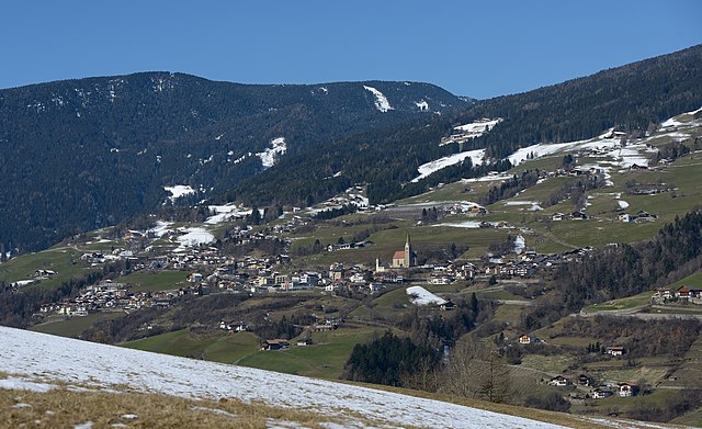
Barbian (Barbiano)
.svg)
- Italian comune
 Hiking in Barbian
Barbian, located in the South Tyrol region of northern Italy, is a beautiful destination for hiking enthusiasts. Nestled in the scenic Dolomites, Barbian offers a mix of well-marked trails that vary in difficulty, making it suitable for both beginners and experienced hikers.
Hiking Highlights in Barbian:
-
Stunning Scenery: The landscape around Barbian is characterized by dramatic mountain peaks, lush forests, and picturesque meadows. Hiking here provides breathtaking views of the Dolomites and the surrounding valleys.
-
Trail Options:
- Beginner Trails: There are several easy trails that are perfect for families or those new to hiking. These often lead through beautiful meadows and offer gentle inclines.
- Intermediate Trails: For more experienced hikers, there are moderate trails that venture deeper into the mountains, offering more challenging terrain and rewarding vistas.
- Advanced Trails: Those seeking a real challenge can tackle advanced routes that may include steeper ascents and rocky paths, requiring proper gear and preparation.
-
Local Flora and Fauna: Hikers can enjoy diverse ecosystems with unique plant species and abundant wildlife. Keep an eye out for local animals such as deer, chamois, and a variety of bird species.
-
Cultural Aspects: The trails often pass through quaint villages and historic sites, allowing hikers to experience the cultural heritage of the region, including local cuisine and traditional architecture.
-
Seasonal Considerations: Hiking in Barbian can be enjoyed in different seasons. Summer is ideal for full access to trails, while winter may offer opportunities for snowshoeing or winter hiking, depending on snow conditions.
-
Safety and Preparation: As with any hiking, it’s important to be prepared. Ensure you wear appropriate footwear, carry enough water, a map or GPS, and let someone know your hiking plans. Weather can change quickly in the mountains, so dress in layers and be ready for varying conditions.
-
Guided Hikes: If you're unfamiliar with the area, consider joining a guided hike. Local guides can provide insights into the geography, flora, and history of the region, enhancing your hiking experience.
Barbian is a wonderful destination for those looking to explore the natural beauty of the Dolomites while enjoying the tranquility that comes with hiking in this stunning part of Italy.
- Country:

- Postal Code: 39040
- Local Dialing Code: 0471
- Licence Plate Code: BZ
- Coordinates: 46° 36' 12" N, 11° 31' 17" E


- GPS tracks (wikiloc): [Link]
- AboveSeaLevel: 836 м m
- Area: 24.51 sq km
- Population: 1699
- Web site: http://www.barbian.eu/
- Wikipedia en: wiki(en)
- Wikipedia: wiki(it)
- Wikidata storage: Wikidata: Q375322
- Wikipedia Commons Gallery: [Link]
- Wikipedia Commons Category: [Link]
- Freebase ID: [/m/0g9fvw]
- GeoNames ID: Alt: [6536006]
- VIAF ID: Alt: [141972042]
- OSM relation ID: [47266]
- GND ID: Alt: [4004494-4]
- archINFORM location ID: [47145]
- Library of Congress authority ID: Alt: [n85354724]
- UN/LOCODE: [ITYBB]
- ISTAT ID: 021007
- Italian cadastre code: A635
Shares border with regions:


Kastelruth
- town and comune in Italy
Hiking in Kastelruth
Kastelruth, located in the beautiful Dolomites region of northern Italy, is a fantastic destination for hiking enthusiasts. The area is known for its stunning landscapes, diverse trails, and charming alpine villages. Here are some highlights and tips for hiking in Kastelruth:...
- Country:
- Postal Code: 39040
- Local Dialing Code: 0471
- Licence Plate Code: BZ
- Coordinates: 46° 34' 0" N, 11° 33' 40" E
- GPS tracks (wikiloc): [Link]
- AboveSeaLevel: 2958 м m
- Area: 117.9 sq km
- Population: 6872
- Web site: [Link]


Lajen
- Italian comune
Hiking in Lajen
Lajen, or Laion, is a picturesque village located in the South Tyrol region of northern Italy, known for its stunning scenery and outdoor recreational opportunities, including hiking. The area is nestled in the Val Gardena valley, surrounded by the breathtaking Dolomites, a UNESCO World Heritage Site, which offers a wealth of hiking trails for all levels of experience....
- Country:
- Postal Code: 39040
- Local Dialing Code: 0471
- Licence Plate Code: BZ
- Coordinates: 46° 36' 29" N, 11° 33' 56" E
- GPS tracks (wikiloc): [Link]
- AboveSeaLevel: 1093 м m
- Area: 37.53 sq km
- Population: 2675
- Web site: [Link]


Waidbruck
- Italian comune
Hiking in Waidbruck
Waidbruck, a small village in South Tyrol, Italy, offers some beautiful hiking opportunities, combining stunning alpine scenery with rich cultural experiences. Here are some highlights and tips for hiking in the area:...
- Country:
- Postal Code: 39040
- Local Dialing Code: 0471
- Licence Plate Code: BZ
- Coordinates: 46° 35' 50" N, 11° 31' 51" E
- GPS tracks (wikiloc): [Link]
- AboveSeaLevel: 471 м m
- Area: 2.33 sq km
- Population: 193
- Web site: [Link]


Ritten
- Italian comune
Hiking in Ritten
Ritten, also known as Renon, is a picturesque area located in South Tyrol, Italy, just outside of Bolzano. It offers a fantastic hiking experience with its stunning landscapes, diverse trails, and panoramic views of the Dolomites. Here are some highlights and tips for hiking in Ritten:...
- Country:
- Postal Code: 39054
- Local Dialing Code: 0471
- Licence Plate Code: BZ
- Coordinates: 46° 32' 29" N, 11° 27' 26" E
- GPS tracks (wikiloc): [Link]
- AboveSeaLevel: 1154 м m
- Area: 111.36 sq km
- Population: 7892
- Web site: [Link]

Villanders
- Italian comune
Hiking in Villanders
Villanders, located in South Tyrol, Italy, is a picturesque village that offers a variety of hiking opportunities amidst stunning alpine scenery. Here are some highlights for hiking in this area:...
- Country:
- Postal Code: 39043
- Local Dialing Code: 0472
- Licence Plate Code: BZ
- Coordinates: 46° 37' 51" N, 11° 32' 13" E
- GPS tracks (wikiloc): [Link]
- AboveSeaLevel: 880 м m
- Area: 43.95 sq km
- Population: 1853
- Web site: [Link]