
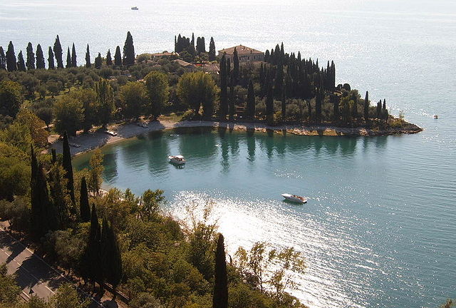
Bardolino (Bardolino)
.svg)
- Italian comune
 Hiking in Bardolino
Bardolino is a picturesque town located on the eastern shore of Lake Garda in Italy. The area is known for its beautiful landscapes, scenic views, and vineyard-covered hills, making it a great destination for hikers. Here are some highlights to consider when hiking in Bardolino:
Hiking Trails
-
Sentiero del Vino: This is the classic wine trail that meanders through vineyards, olive groves, and charming villages. It offers stunning views of Lake Garda and the surrounding landscape.
-
Monte Baldo: A bit further from Bardolino, Monte Baldo is accessible by cable car from nearby Malcesine. Once at the top, there are numerous trails with varying difficulty, providing breathtaking views of the lake and the Alps.
-
Passeggiata della Rocca: This trail takes you around the Rocca di Bardolino, an ancient fortress. It’s a relatively easy walk that provides great views over the town and the lake.
-
Lago di Garda Trail: The trail that runs along the entire length of Lake Garda offers numerous access points in Bardolino. It varies in difficulty and terrain, and you can choose segments that fit your skill level.
Tips for Hiking in Bardolino
- Best Time to Hike: Spring (April to June) and early autumn (September to October) are ideal for hiking, as the weather is usually pleasant and the landscape is vibrant with greenery.
- Trail Maps: Make sure to have a map or a hiking app for navigation, as some trails may not be well-marked.
- Hydration and Snacks: Bring enough water and snacks, especially for longer hikes.
- Footwear: Wear comfortable, sturdy hiking boots to handle the various terrains, from gravel paths to rocky trails.
- Respect Nature: Stay on marked paths and follow Leave No Trace principles to help preserve the natural beauty.
Local Attractions
In addition to hiking, Bardolino offers charming streets filled with shops, restaurants, and wine tasting opportunities. Don’t miss trying the local Bardolino wine, which is well-known for its quality.
Hiking in Bardolino provides a fantastic way to experience the natural beauty of the Lake Garda region while enjoying the cultural and historical richness of the area. Happy hiking!
- Country:

- Postal Code: 37011
- Local Dialing Code: 045
- Licence Plate Code: VR
- Coordinates: 45° 33' 6" N, 10° 43' 17" E


- GPS tracks (wikiloc): [Link]
- AboveSeaLevel: 65 м m
- Area: 57.33 sq km
- Population: 7147
- Web site: http://www.comune.bardolino.vr.it/
- Wikipedia en: wiki(en)
- Wikipedia: wiki(it)
- Wikidata storage: Wikidata: Q46870
- Wikipedia Commons Gallery: [Link]
- Wikipedia Commons Category: [Link]
- Freebase ID: [/m/0gb1rq]
- GeoNames ID: Alt: [6540240]
- VIAF ID: Alt: [168339873]
- OSM relation ID: [45204]
- archINFORM location ID: [1127]
- MusicBrainz area ID: [7d2f53f7-8e45-473f-904f-56a833e1cccf]
- Quora topic ID: [Bardolino]
- UN/LOCODE: [ITBLI]
- ISTAT ID: 023006
- Italian cadastre code: A650
Shares border with regions:

Manerba del Garda
- Italian comune
Hiking in Manerba del Garda
Manerba del Garda is a beautiful area located on the western shore of Lake Garda in northern Italy. The region is known for its stunning natural scenery, rich history, and a variety of hiking paths that cater to different skill levels. Here are some key highlights and tips for hiking in Manerba del Garda:...
- Country:
- Postal Code: 25080
- Local Dialing Code: 0365
- Licence Plate Code: BS
- Coordinates: 45° 32' 59" N, 10° 33' 5" E
- GPS tracks (wikiloc): [Link]
- AboveSeaLevel: 130 м m
- Area: 36.63 sq km
- Population: 5357
- Web site: [Link]

Moniga del Garda
- Italian comune
Hiking in Moniga del Garda
Moniga del Garda is a charming town located on the western shore of Lake Garda in Italy. It offers beautiful scenery, lovely views of the lake, and a pleasant Mediterranean climate, making it a great destination for hiking enthusiasts. Here are some details about hiking in the area:...
- Country:
- Postal Code: 25080
- Local Dialing Code: 0365
- Licence Plate Code: BS
- Coordinates: 45° 31' 37" N, 10° 32' 20" E
- GPS tracks (wikiloc): [Link]
- AboveSeaLevel: 125 м m
- Area: 14.65 sq km
- Population: 2575
- Web site: [Link]

Padenghe sul Garda
- Italian comune
Hiking in Padenghe sul Garda
Padenghe sul Garda, located on the southwestern shore of Lake Garda in Italy, offers a beautiful backdrop for hiking enthusiasts. The area is characterized by its stunning lake views, rolling hills, olive groves, and vineyards. Here’s what you can expect when hiking in and around Padenghe sul Garda:...
- Country:
- Postal Code: 25080
- Local Dialing Code: 030
- Licence Plate Code: BS
- Coordinates: 45° 30' 30" N, 10° 30' 59" E
- GPS tracks (wikiloc): [Link]
- AboveSeaLevel: 127 м m
- Area: 26.81 sq km
- Population: 4629
- Web site: [Link]


Affi
- Italian comune
Hiking in Affi
Affi is a picturesque village located near Lake Garda in northern Italy, making it a great base for hiking and exploring the beautiful surrounding areas. The region is known for its stunning landscapes, vineyards, and rural charm. Here are some key aspects to consider when hiking in and around Affi:...
- Country:
- Postal Code: 37010
- Local Dialing Code: 045
- Licence Plate Code: VR
- Coordinates: 45° 33' 0" N, 10° 46' 0" E
- GPS tracks (wikiloc): [Link]
- AboveSeaLevel: 191 м m
- Area: 9.88 sq km
- Population: 2333
- Web site: [Link]


Costermano sul Garda
- Italian comune
Hiking in Costermano sul Garda
Costermano sul Garda is a charming village located near Lake Garda in northern Italy, renowned for its beautiful landscapes and scenic hiking opportunities. Here's what you can expect when hiking in this area:...
- Country:
- Postal Code: 37010
- Local Dialing Code: 045
- Licence Plate Code: VR
- Coordinates: 45° 35' 0" N, 10° 44' 0" E
- GPS tracks (wikiloc): [Link]
- AboveSeaLevel: 237 м m
- Area: 16.74 sq km
- Population: 3749
- Web site: [Link]


Lazise
- Italian comune
Hiking in Lazise
Lazise is a charming town located on the eastern shore of Lake Garda in Italy. Known for its beautiful landscapes, historical sites, and Mediterranean climate, it offers a variety of hiking opportunities for outdoor enthusiasts....
- Country:
- Postal Code: 37017
- Local Dialing Code: 045
- Licence Plate Code: VR
- Coordinates: 45° 30' 19" N, 10° 43' 57" E
- GPS tracks (wikiloc): [Link]
- AboveSeaLevel: 76 м m
- Area: 63.15 sq km
- Population: 6958
- Web site: [Link]

Garda
- Italian comune
Hiking in Garda
Hiking in the Garda region of Veneto is a fantastic way to explore the stunning landscapes and natural beauty that the area has to offer. Lake Garda, the largest lake in Italy, is surrounded by picturesque towns, rolling hills, and majestic mountains. Here are some highlights and tips for hiking in this beautiful region:...
- Country:
- Postal Code: 37016
- Local Dialing Code: 045
- Licence Plate Code: VR
- Coordinates: 45° 34' 21" N, 10° 40' 18" E
- GPS tracks (wikiloc): [Link]
- AboveSeaLevel: 67 м m
- Area: 14.37 sq km
- Population: 4117
- Web site: [Link]
Cavaion Veronese
- Italian comune
Hiking in Cavaion Veronese
Cavaion Veronese is a picturesque village located in the Veneto region of Italy, not far from Lake Garda. The surrounding area offers a variety of hiking opportunities with beautiful views of the lake, rolling hills, vineyards, and rural landscapes....
- Country:
- Postal Code: 37010
- Local Dialing Code: 045
- Licence Plate Code: VR
- Coordinates: 45° 32' 24" N, 10° 46' 14" E
- GPS tracks (wikiloc): [Link]
- AboveSeaLevel: 190 м m
- Area: 12.91 sq km
- Population: 5924
- Web site: [Link]


Pastrengo
- Italian comune
Hiking in Pastrengo
Pastrengo, located in the Veneto region of Italy near Lake Garda, offers a variety of hiking opportunities. The area features beautiful landscapes, including rolling hills, vineyards, and historical sites, making it an excellent destination for hikers of all experience levels....
- Country:
- Postal Code: 37010
- Local Dialing Code: 045
- Licence Plate Code: VR
- Coordinates: 45° 30' 0" N, 10° 48' 0" E
- GPS tracks (wikiloc): [Link]
- AboveSeaLevel: 192 м m
- Area: 9 sq km
- Population: 3092
- Web site: [Link]