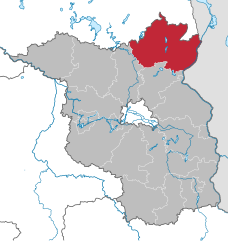
Barnim District (Landkreis Barnim)

- District in Brandenburg, Germany
 Hiking in Barnim District
Barnim, located in Brandenburg, Germany, offers a great variety of hiking opportunities, thanks to its stunning natural landscapes, forests, and historical sites. Here are some key highlights of hiking in the Barnim region:
Natural Attractions
-
Barnim Nature Park: This large nature park is ideal for hiking, featuring a mix of dense forests, meadows, and glacial valleys. There are numerous marked trails catering to different levels of hikers.
-
Forests: The region is characterized by vast woodlands that are home to diverse flora and fauna. Trails through these forests often lead to serene spots perfect for picnicking or resting.
-
Rivers and Lakes: The area features lovely water bodies, such as the River Panke and various small lakes, providing beautiful scenery along hiking routes.
Popular Hiking Trails
-
Berlin to Usedom Trail: This long-distance trail connects Berlin to the Baltic Sea, passing through Barnim and offering hikers a chance to explore several landscapes, towns, and villages along the way.
-
The Barnim Panorama: This loop trail includes various points of interest, including historical villages and lookout points, offering breathtaking views of the countryside.
-
Local Circular Trails: Many villages in Barnim, such as Eberswalde and Bernau, have their own circular trails that showcase local history and nature.
Tips for Hiking in Barnim
- Trail Markings: Keep an eye on trail signs, as most routes are well-marked, allowing you to navigate easily.
- Weather Considerations: Check the local weather forecast before heading out, as conditions can change quickly, especially in forested areas.
- Respect Nature: Remember to stay on designated paths to protect flora and fauna, and carry out any waste to keep the area clean.
- Local Culture: Take time to appreciate the local culture, with opportunities to visit traditional towns, local handicrafts, and regional cuisine.
Accessibility
Barnim is easily accessible from Berlin, making it a popular choice for day hikes. Public transport options like trains and buses can get you close to major hiking points.
Overall, hiking in Barnim offers a blend of natural beauty, adventure, and cultural experiences. Whether you're a seasoned hiker or a beginner, you'll find trails that suit your interests and fitness level.
- Country:

- Licence Plate Code: EW; BER; BAR
- Coordinates: 52° 50' 0" N, 13° 45' 0" E


- GPS tracks (wikiloc): [Link]
- AboveSeaLevel: 32 м m
- Area: 1.49 sq km
- Population: 173193
- Web site: http://www.barnim.de/
- Wikipedia en: wiki(en)
- Wikipedia: wiki(de)
- Wikidata storage: Wikidata: Q6115
- Wikipedia Commons Category: [Link]
- Wikipedia Commons Maps Category: [Link]
- Freebase ID: [/m/015yfg]
- GeoNames ID: Alt: [3249079]
- VIAF ID: Alt: [159840715]
- OSM relation ID: [62553]
- GND ID: Alt: [4393872-3]
- archINFORM location ID: [2338]
- Library of Congress authority ID: Alt: [n95010252]
- TGN ID: [7076945]
- ISNI: Alt: [0000 0004 0427 6389]
- National Library of Israel ID: [001035880]
- NUTS code: [DE405]
- Ringgold ID: [160589]
- BabelNet ID: [00886423n]
- German district key: 12060
Shares border with regions:

Uckermark District
- District in Brandenburg state, Germany
Hiking in Uckermark District
Hiking in the Uckermark district, located in the northeastern part of Germany, is a delight for nature enthusiasts. This picturesque region is characterized by its rolling landscapes, serene lakes, and lush forests, making it an ideal destination for outdoor exploration....
- Country:
- Capital: Prenzlau
- Licence Plate Code: ANG; PZ; SDT; TP; UM
- Coordinates: 53° 15' 0" N, 13° 52' 0" E
- GPS tracks (wikiloc): [Link]
- AboveSeaLevel: 20 м m
- Area: 3058.08 sq km
- Population: 121326
- Web site: [Link]
Oberhavel District
- district in Brandenburg state, Germany
Hiking in Oberhavel District
Oberhavel is a beautiful district located in the state of Brandenburg, Germany, known for its picturesque landscapes, lush forests, and numerous lakes. It's a fantastic destination for hiking enthusiasts. Here are some key points to consider when hiking in Oberhavel:...
- Country:
- Licence Plate Code: OHV
- Coordinates: 52° 53' 0" N, 13° 15' 0" E
- GPS tracks (wikiloc): [Link]
- AboveSeaLevel: 67 м m
- Area: 1795.77 sq km
- Population: 202162
- Web site: [Link]
Märkisch-Oderland District
- District of Brandenburg state, Germany
Hiking in Märkisch-Oderland District
Märkisch-Oderland, located in the state of Brandenburg, Germany, offers a diverse and captivating environment for hiking enthusiasts. The region is characterized by its scenic landscapes, which include forests, lakes, rivers, and rolling hills....
- Country:
- Licence Plate Code: SRB; SEE; MOL; FRW
- Coordinates: 52° 38' 0" N, 14° 8' 0" E
- GPS tracks (wikiloc): [Link]
- AboveSeaLevel: 9 м m
- Area: 2127.99 sq km
- Population: 186925
- Web site: [Link]


Berlin
- capital and largest city of Germany
Hiking in Berlin
Hiking in and around Berlin offers a unique blend of urban exploration and access to nature. While Berlin itself is a bustling metropolis, there are various parks, forested areas, and nearby trails that provide excellent opportunities for hiking. Here are some highlights:...
- Country:
- Postal Code: 10115–14199
- Local Dialing Code: 030
- Licence Plate Code: B; I
- Coordinates: 52° 31' 0" N, 13° 23' 0" E
- GPS tracks (wikiloc): [Link]
- AboveSeaLevel: 34 м m
- Area: 891.12 sq km
- Population: 3611222
- Web site: [Link]