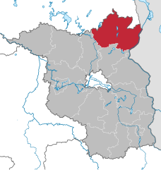
Oberhavel District (Landkreis Oberhavel)

- district in Brandenburg state, Germany
 Hiking in Oberhavel District
Oberhavel is a beautiful district located in the state of Brandenburg, Germany, known for its picturesque landscapes, lush forests, and numerous lakes. It's a fantastic destination for hiking enthusiasts. Here are some key points to consider when hiking in Oberhavel:
1.
- Oberhavel offers a variety of hiking trails that cater to different skill levels, from easy walks suitable for families to more challenging routes for experienced hikers.
- The Havel River offers several trails alongside the water, allowing hikers to enjoy the serene views and opportunities for birdwatching.
2.
- The district is home to several protected areas, like the Havelland Nature Park, which provides well-marked trails and insights into the local flora and fauna.
- Lieberoser Platte and Siegertsbrunn Nature Reserve also offer stunning natural scenery and the chance to see unique wildlife.
3.
- Oberhavel features a network of lakes, including Lake Tegel and the Müritz. Hiking around these waterways not only provides beautiful views but also opportunities for other activities, like swimming or kayaking.
4.
- Along the hiking trails, you might encounter charming villages and historical sites, such as the Priepert and Fürstenberg towns, where you can learn about the local history and culture.
5.
- The best times for hiking in Oberhavel are spring (April to June) and autumn (September to October) when the weather is mild, and the natural scenery is particularly beautiful.
6.
- Stay hydrated: Bring enough water, especially during summer months.
- Dress appropriately: Wear comfortable, weather-appropriate clothing and sturdy footwear.
- Pack essentials: Include a first-aid kit, snacks, a map or GPS device, and a mobile phone for emergencies.
- Respect nature: Follow Leave No Trace principles to preserve the natural environment.
7.
- Many trails are well-marked, but it’s advisable to carry a map or use hiking apps to ensure you stay on course.
Conclusion:
Oberhavel is a wonderful place for hiking, blending natural beauty with cultural insights. Whether you’re looking for a tranquil day hike or a more challenging adventure, you’re sure to find a trail that suits your needs. Enjoy your hiking experience in this stunning part of Germany!
- Country:

- Licence Plate Code: OHV
- Coordinates: 52° 53' 0" N, 13° 15' 0" E


- GPS tracks (wikiloc): [Link]
- AboveSeaLevel: 67 м m
- Area: 1795.77 sq km
- Population: 202162
- Web site: http://www.oberhavel.de/
- Wikipedia en: wiki(en)
- Wikipedia: wiki(de)
- Wikidata storage: Wikidata: Q6119
- Wikipedia Commons Category: [Link]
- Wikipedia Commons Maps Category: [Link]
- Freebase ID: [/m/015hkh]
- GeoNames ID: Alt: [3249084]
- VIAF ID: Alt: [134507397]
- OSM relation ID: [62488]
- GND ID: Alt: [4363444-8]
- archINFORM location ID: [5918]
- TGN ID: [7076940]
- NUTS code: [DE40A]
- German district key: 12065
Shares border with regions:

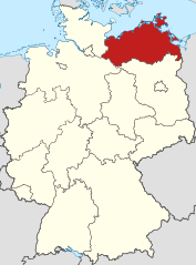
Mecklenburg-Vorpommern
- state of Germany
Hiking in Mecklenburg-Vorpommern
Mecklenburg-Vorpommern, a picturesque state in northeastern Germany, offers a wealth of hiking opportunities for enthusiasts of all levels. This region is known for its diverse landscapes, which include vast forests, serene lakes, and a stunning coastline along the Baltic Sea. Here are some highlights and tips for hiking in this beautiful area:...
- Country:
- Capital: Schwerin
- Coordinates: 53° 37' 0" N, 12° 42' 0" E
- GPS tracks (wikiloc): [Link]
- AboveSeaLevel: 0 м m
- Area: 23174.0 sq km
- Population: 1596500
- Web site: [Link]

Uckermark District
- District in Brandenburg state, Germany
Hiking in Uckermark District
Hiking in the Uckermark district, located in the northeastern part of Germany, is a delight for nature enthusiasts. This picturesque region is characterized by its rolling landscapes, serene lakes, and lush forests, making it an ideal destination for outdoor exploration....
- Country:
- Capital: Prenzlau
- Licence Plate Code: ANG; PZ; SDT; TP; UM
- Coordinates: 53° 15' 0" N, 13° 52' 0" E
- GPS tracks (wikiloc): [Link]
- AboveSeaLevel: 20 м m
- Area: 3058.08 sq km
- Population: 121326
- Web site: [Link]
Barnim District
- District in Brandenburg, Germany
Hiking in Barnim District
Barnim, located in Brandenburg, Germany, offers a great variety of hiking opportunities, thanks to its stunning natural landscapes, forests, and historical sites. Here are some key highlights of hiking in the Barnim region:...
- Country:
- Licence Plate Code: EW; BER; BAR
- Coordinates: 52° 50' 0" N, 13° 45' 0" E
- GPS tracks (wikiloc): [Link]
- AboveSeaLevel: 32 м m
- Area: 1.49 sq km
- Population: 173193
- Web site: [Link]
Ostprignitz-Ruppin District
- district in Brandenburg state, Germany
Hiking in Ostprignitz-Ruppin District
Ostprignitz-Ruppin, located in the northeastern part of Brandenburg, Germany, offers a unique and picturesque hiking experience. The region is characterized by its diverse landscapes, which include sprawling forests, rolling hills, glacial lakes, and historical sites. Here are some highlights and tips for hiking in this area:...
- Country:
- Licence Plate Code: WK; OPR; NP; KY
- Coordinates: 52° 58' 0" N, 12° 40' 0" E
- GPS tracks (wikiloc): [Link]
- AboveSeaLevel: 53 м m
- Area: 2509.22 sq km
- Population: 99125
- Web site: [Link]
Havelland District
- District in Brandenburg state, Germany
Hiking in Havelland District
Havelland, located in the Brandenburg region of Germany, offers a rich tapestry of hiking opportunities for nature enthusiasts and outdoor adventurers. Here’s what you can expect when hiking in this picturesque district:...
- Country:
- Licence Plate Code: HVL
- Coordinates: 52° 38' 0" N, 12° 38' 0" E
- GPS tracks (wikiloc): [Link]
- AboveSeaLevel: 32 м m
- Area: 1717.00 sq km
- Population: 153294
- Web site: [Link]


Berlin
- capital and largest city of Germany
Hiking in Berlin
Hiking in and around Berlin offers a unique blend of urban exploration and access to nature. While Berlin itself is a bustling metropolis, there are various parks, forested areas, and nearby trails that provide excellent opportunities for hiking. Here are some highlights:...
- Country:
- Postal Code: 10115–14199
- Local Dialing Code: 030
- Licence Plate Code: B; I
- Coordinates: 52° 31' 0" N, 13° 23' 0" E
- GPS tracks (wikiloc): [Link]
- AboveSeaLevel: 34 м m
- Area: 891.12 sq km
- Population: 3611222
- Web site: [Link]