Bauzy (Bauzy)

- commune in Loir-et-Cher, France
- Country:

- Postal Code: 41250
- Coordinates: 47° 32' 7" N, 1° 36' 29" E


- GPS tracks (wikiloc): [Link]
- Area: 24.7 sq km
- Population: 285
- Wikipedia en: wiki(en)
- Wikipedia: wiki(fr)
- Wikidata storage: Wikidata: Q671448
- Wikipedia Commons Category: [Link]
- Freebase ID: [/m/03nv_10]
- GeoNames ID: Alt: [3034516]
- SIREN number: [214100133]
- BnF ID: [15259289j]
- INSEE municipality code: 41013
Shares border with regions:


Dhuizon
- commune in Loir-et-Cher, France
- Country:
- Postal Code: 41220
- Coordinates: 47° 35' 18" N, 1° 39' 29" E
- GPS tracks (wikiloc): [Link]
- Area: 43.34 sq km
- Population: 1230
- Web site: [Link]


Courmemin
- commune in Loir-et-Cher, France
- Country:
- Postal Code: 41230
- Coordinates: 47° 28' 19" N, 1° 37' 37" E
- GPS tracks (wikiloc): [Link]
- Area: 24.17 sq km
- Population: 526

Neuvy
- commune in Loir-et-Cher, France
- Country:
- Postal Code: 41250
- Coordinates: 47° 33' 47" N, 1° 36' 10" E
- GPS tracks (wikiloc): [Link]
- Area: 31.28 sq km
- Population: 314

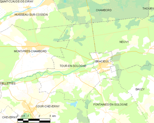
Tour-en-Sologne
- commune in Loir-et-Cher, France
- Country:
- Postal Code: 41250
- Coordinates: 47° 32' 20" N, 1° 30' 0" E
- GPS tracks (wikiloc): [Link]
- Area: 26.34 sq km
- Population: 1095


Fontaines-en-Sologne
- commune in Loir-et-Cher, France
- Country:
- Postal Code: 41250
- Coordinates: 47° 30' 34" N, 1° 33' 3" E
- GPS tracks (wikiloc): [Link]
- Area: 46.25 sq km
- Population: 630

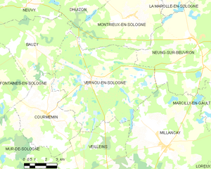
Vernou-en-Sologne
- commune in Loir-et-Cher, France
- Country:
- Postal Code: 41230
- Coordinates: 47° 30' 5" N, 1° 40' 48" E
- GPS tracks (wikiloc): [Link]
- Area: 51.31 sq km
- Population: 618
- Web site: [Link]
Montrieux-en-Sologne
- commune in Loir-et-Cher, France
- Country:
- Postal Code: 41210
- Coordinates: 47° 33' 12" N, 1° 43' 25" E
- GPS tracks (wikiloc): [Link]
- Area: 34.11 sq km
- Population: 674