
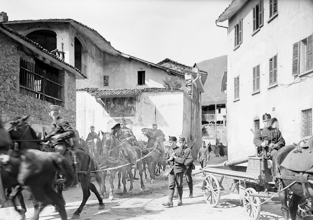
Bellinzona (Bellinzona)

- capital city of the canton of Ticino, Switzerland
 Hiking in Bellinzona
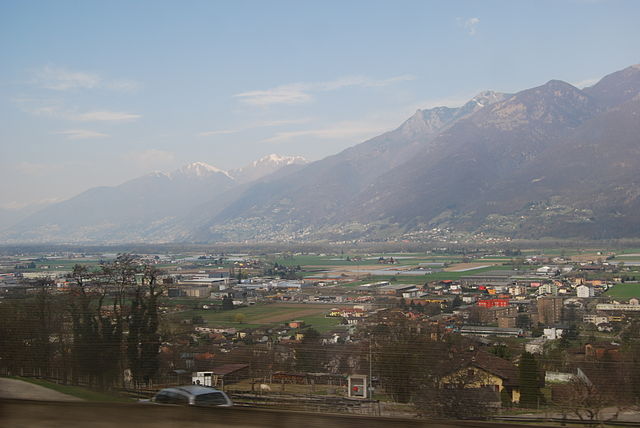
Bellinzona, located in the Ticino region of Switzerland, is an excellent destination for hiking enthusiasts. The area is renowned for its stunning landscapes, rich history, and a network of well-marked hiking trails that cater to various skill levels. Here are some highlights and recommendations for hiking in and around Bellinzona:
Key Features:
-
Stunning Scenery: The region offers breathtaking views of the surrounding mountains, valleys, and the historic castles of Bellinzona, which are UNESCO World Heritage sites.
-
Castle Hikes: The three main castles—Castelgrande, Montebello, and Sasso Corbaro—are easily accessible and provide beautiful hiking routes that connect them. You can enjoy a mix of culture and nature.
-
Diverse Trail Options: There are numerous trails ranging from easy walks to more challenging hikes. Popular routes include:
- The Trail of the Castles: This route lets you explore Bellinzona’s historical sites while enjoying panoramic views.
- The Valle di Rivera: A scenic hike that leads through lush forests and offers a chance to see waterfalls and charming villages.
-
Mountain Hiking: For those looking for a more challenging experience, consider trails that ascend into the nearby mountains, such as the peaks of the Lepontine Alps, where you can find both marked paths and more rugged terrain.
-
Accessibility: The region is well connected through public transport, making it easy to access trailheads without needing to drive.
-
Seasonal Hiking: Late spring to early fall (May to October) is the best time for hiking, as trails are generally clear of snow, and the weather is mild.
Useful Tips:
- Equipment: Make sure to wear sturdy hiking boots and carry a map or GPS device, especially if you plan to explore more remote areas.
- Water and Snacks: Carry enough water and some snacks, as some trails might have limited facilities.
- Weather Check: Always check the weather forecast before heading out, as mountain weather can change rapidly.
- Respect the Environment: Follow local guidelines to preserve the natural beauty of the region and stay on marked trails.
Overall, hiking in Bellinzona is a beautiful way to experience the natural and cultural heritage of the region. Whether you're looking for a leisurely walk or a challenging expedition, you'll find something that matches your interests in this picturesque area of Switzerland.
- Country:

- Postal Code: 6500
- Local Dialing Code: 091
- Licence Plate Code: TI
- Coordinates: 46° 11' 44" N, 9° 1' 26" E


- GPS tracks (wikiloc): [Link]
- AboveSeaLevel: 230 м m
- Area: 164.96 sq km
- Population: 42615
- Web site: http://www.bellinzona.ch
- Wikipedia en: wiki(en)
- Wikipedia: wiki(de)
- Wikidata storage: Wikidata: Q64044
- Wikipedia Commons Gallery: [Link]
- Wikipedia Commons Category: [Link]
- Freebase ID: [/m/033v4v]
- GeoNames ID: Alt: [2661567]
- BnF ID: [11974533m]
- VIAF ID: Alt: [128990305]
- OSM relation ID: [1684625]
- GND ID: Alt: [4005432-9]
- archINFORM location ID: [1589]
- Library of Congress authority ID: Alt: [n79034885]
- MusicBrainz area ID: [c4b19e67-677d-4d35-86f8-9962f6a1172e]
- Encyclopædia Britannica Online ID: [place/Bellinzona]
- HDS ID: [2031]
- Great Russian Encyclopedia Online ID: [1854119]
- Swiss municipality code: [5002]
- Digital Atlas of the Roman Empire ID: [10794]
Shares border with regions:
Cavargna
- Italian comune
Hiking in Cavargna
Cavargna is a picturesque village located in the Italian region of Lombardy, near the border with Switzerland. It's known for its stunning natural landscapes, making it a great destination for hiking enthusiasts. Here are some key points about hiking in Cavargna:...
- Country:

- Postal Code: 22010
- Local Dialing Code: 0344
- Licence Plate Code: CO
- Coordinates: 46° 5' 0" N, 9° 7' 0" E
- GPS tracks (wikiloc): [Link]
- AboveSeaLevel: 1071 м m
- Area: 14.98 sq km
- Population: 212
- Web site: [Link]
San Nazzaro Val Cavargna
- Italian comune
Hiking in San Nazzaro Val Cavargna
San Nazzaro Val Cavargna is a picturesque village located in the province of Como, in the Lombardy region of Italy. Nestled in the Val Cavargna valley, it offers a range of excellent hiking opportunities amid stunning natural landscapes, rich flora, and charming traditional architecture....
- Country:
- Postal Code: 22010
- Local Dialing Code: 0344
- Licence Plate Code: CO
- Coordinates: 46° 5' 0" N, 9° 8' 0" E
- GPS tracks (wikiloc): [Link]
- AboveSeaLevel: 995 м m
- Area: 12.99 sq km
- Population: 302
- Web site: [Link]


Roveredo
- municipality in Graubünden, Switzerland
Hiking in Roveredo
Roveredo is a quaint town located in the Mendrisiotto region of Ticino, Switzerland. Surrounded by stunning natural landscapes, it offers several hiking opportunities that cater to a variety of skill levels. Here are some highlights of hiking in Roveredo:...
- Country:
- Postal Code: 6535
- Local Dialing Code: 091
- Licence Plate Code: GR
- Coordinates: 46° 14' 5" N, 9° 7' 33" E
- GPS tracks (wikiloc): [Link]
- AboveSeaLevel: 1239 м m
- Area: 38.79 sq km
- Population: 2483
- Web site: [Link]


San Vittore
- municipality in Graubünden, Switzerland
Hiking in San Vittore
San Vittore, located in the canton of Graubünden in Switzerland, offers a variety of hiking opportunities amidst stunning alpine scenery. Here’s an overview of what to expect when hiking in this beautiful region:...
- Country:
- Postal Code: 6534
- Local Dialing Code: 091
- Licence Plate Code: GR
- Coordinates: 46° 14' 17" N, 9° 6' 22" E
- GPS tracks (wikiloc): [Link]
- AboveSeaLevel: 688 м m
- Area: 22.06 sq km
- Population: 825
- Web site: [Link]


Lumino
- municipality in Switzerland
Hiking in Lumino
Lumino is a picturesque village located in the Canton of Ticino, Switzerland, known for its beautiful landscapes and hiking opportunities. The region offers a range of trails suitable for different skill levels, from easy walks to more challenging hikes....
- Country:
- Postal Code: 6533
- Local Dialing Code: 091
- Licence Plate Code: TI
- Coordinates: 46° 14' 18" N, 9° 4' 5" E
- GPS tracks (wikiloc): [Link]
- AboveSeaLevel: 483 м m
- Area: 9.92 sq km
- Population: 1470
- Web site: [Link]


Sant'Antonino
- municipality in the canton of Ticino, Switzerland
Hiking in Sant'Antonino
Sant'Antonino, a picturesque village located in the heart of the Ticino region of Switzerland, offers a fantastic backdrop for hiking enthusiasts. Nestled in the foothills of the Swiss Alps, it allows hikers to immerse themselves in stunning landscapes, lush forests, and panoramic vistas....
- Country:
- Postal Code: 6592
- Local Dialing Code: 091
- Licence Plate Code: TI
- Coordinates: 46° 9' 0" N, 8° 59' 0" E
- GPS tracks (wikiloc): [Link]
- AboveSeaLevel: 226 м m
- Area: 6.64 sq km
- Population: 2513
- Web site: [Link]

Ponte Capriasca
- municipality in the canton of Ticino, Switzerland
Hiking in Ponte Capriasca
Ponte Capriasca is a charming village located in the Lugano district of southern Switzerland. Surrounded by the picturesque landscapes of the Ticino region, it offers a variety of hiking trails that cater to different skill levels. Here are some key points to consider for hiking in and around Ponte Capriasca:...
- Country:
- Postal Code: 6946
- Local Dialing Code: 091
- Licence Plate Code: TI
- Coordinates: 46° 4' 0" N, 8° 57' 0" E
- GPS tracks (wikiloc): [Link]
- AboveSeaLevel: 447 м m
- Area: 6.2 sq km
- Population: 1889
- Web site: [Link]

Cugnasco-Gerra
- municipality in the canton of Ticino, Switzerland
Hiking in Cugnasco-Gerra
Cugnasco-Gerra is a charming area located in the Canton of Ticino, Switzerland. This region offers beautiful landscapes, scenic trails, and a variety of hiking opportunities suitable for different skill levels. Here are some highlights for hiking in Cugnasco-Gerra:...
- Country:
- Postal Code: 6516, 6635, 6597
- Local Dialing Code: 091
- Licence Plate Code: TI
- Coordinates: 46° 10' 0" N, 8° 55' 0" E
- GPS tracks (wikiloc): [Link]
- AboveSeaLevel: 225 м m
- Area: 35.8 sq km
- Population: 2877
- Web site: [Link]


Lavertezzo
- municipality in the canton of Ticino, Switzerland
Hiking in Lavertezzo
Lavertezzo, located in the Val Verzasca region of Ticino, Switzerland, is a beautiful hiking destination known for its stunning natural landscapes, distinctive granite formations, and clear turquoise waters. Here are some highlights and tips for hiking in the area:...
- Country:
- Postal Code: 6633
- Local Dialing Code: 091
- Licence Plate Code: TI
- Coordinates: 46° 15' 35" N, 8° 50' 28" E
- GPS tracks (wikiloc): [Link]
- AboveSeaLevel: 1087 м m
- Area: 58.1 sq km
- Population: 1329
- Web site: [Link]

Arbedo-Castione
- municipality in Switzerland
Hiking in Arbedo-Castione
Arbedo-Castione is a picturesque area located in the Canton of Ticino, Switzerland. It's known for its beautiful landscapes, rich history, and a variety of hiking trails suitable for different skill levels. Here are some aspects to consider when hiking in Arbedo-Castione:...
- Country:
- Local Dialing Code: 091
- Licence Plate Code: TI
- Coordinates: 46° 13' 0" N, 9° 3' 0" E
- GPS tracks (wikiloc): [Link]
- AboveSeaLevel: 278 м m
- Area: 21.52 sq km
- Population: 5039
- Web site: [Link]
Cadenazzo
- municipality in Switzerland
Hiking in Cadenazzo
Cadenazzo is a picturesque village located in the Italian-speaking canton of Ticino, Switzerland. It's known for its beautiful landscapes, charming architecture, and proximity to several hiking trails that cater to different skill levels....
- Country:
- Postal Code: 6593
- Local Dialing Code: 091
- Licence Plate Code: TI
- Coordinates: 46° 8' 48" N, 8° 57' 0" E
- GPS tracks (wikiloc): [Link]
- AboveSeaLevel: 296 м m
- Area: 8.44 sq km
- Population: 2932
- Web site: [Link]

Isone
- municipality in Switzerland
Hiking in Isone
Isone is a charming municipality located in the Canton of Ticino, Switzerland. It offers a range of hiking opportunities that showcase the stunning landscapes and natural beauty of the region. Here are some details to consider for hiking in Isone:...
- Country:
- Postal Code: 6810
- Local Dialing Code: 091
- Licence Plate Code: TI
- Coordinates: 46° 8' 1" N, 9° 0' 52" E
- GPS tracks (wikiloc): [Link]
- AboveSeaLevel: 1092 м m
- Area: 12.9 sq km
- Population: 378
- Web site: [Link]

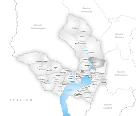
Vogorno
- municipality in the canton of Ticino, Switzerland
Hiking in Vogorno
Vogorno is a beautiful village located in the canton of Ticino, Switzerland, known for its stunning landscapes and natural beauty. It sits near the shores of Lake Verzasca and is surrounded by mountains, making it a fantastic destination for hiking enthusiasts....
- Country:
- Postal Code: 6632
- Local Dialing Code: 091
- Licence Plate Code: TI
- Coordinates: 46° 13' 0" N, 8° 51' 0" E
- GPS tracks (wikiloc): [Link]
- AboveSeaLevel: 461 м m
- Area: 23.9 sq km
- Population: 279