Benais (Benais)

- commune in Indre-et-Loire, France
- Country:

- Postal Code: 37140
- Coordinates: 47° 17' 47" N, 0° 12' 52" E


- GPS tracks (wikiloc): [Link]
- Area: 20.08 sq km
- Population: 949
- Web site: http://www.benais.fr
- Wikipedia en: wiki(en)
- Wikipedia: wiki(fr)
- Wikidata storage: Wikidata: Q660317
- Wikipedia Commons Category: [Link]
- Freebase ID: [/m/03nvd0g]
- GeoNames ID: Alt: [6448646]
- SIREN number: [213700248]
- BnF ID: [152575756]
- INSEE municipality code: 37024
Shares border with regions:

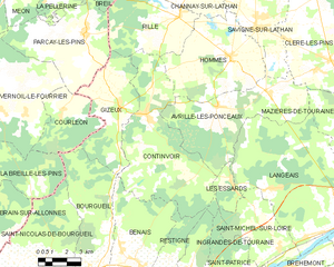
Continvoir
- commune in Indre-et-Loire, France
- Country:
- Postal Code: 37340
- Coordinates: 47° 23' 18" N, 0° 13' 14" E
- GPS tracks (wikiloc): [Link]
- Area: 41.19 sq km
- Population: 420
- Web site: [Link]


Bourgueil
- commune in Indre-et-Loire, France
- Country:
- Postal Code: 37140
- Coordinates: 47° 16' 55" N, 0° 10' 6" E
- GPS tracks (wikiloc): [Link]
- Area: 32.95 sq km
- Population: 3896
- Web site: [Link]

Restigné
- commune in Indre-et-Loire, France
- Country:
- Postal Code: 37140
- Coordinates: 47° 16' 53" N, 0° 13' 42" E
- GPS tracks (wikiloc): [Link]
- Area: 21.31 sq km
- Population: 1262
- Web site: [Link]