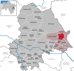
Bergfeld (Bergfeld)
- municipality of Germany
Bergfeld is a scenic area that offers a variety of hiking opportunities for outdoor enthusiasts. Nestled within beautiful landscapes, it typically features well-marked trails that cater to various skill levels, from beginners to more seasoned hikers.
Key Points for Hiking in Bergfeld:
-
Trail Options: There are several trails available, ranging from easy walks to more challenging hikes. Be sure to check local maps or visit a ranger station for recommendations based on your experience level.
-
Scenic Views: The area is known for its stunning views, including lush forests, mountain ranges, and possibly water features like lakes or rivers depending on the specific locale.
-
Wildlife and Flora: Hikers can often encounter diverse wildlife and a variety of plant species. It's great to bring binoculars for birdwatching and a good camera to capture the natural beauty.
-
Weather Considerations: Always check the weather before heading out, as conditions can change rapidly in mountainous areas. Dress in layers and be prepared for potential rain or temperature drops.
-
Safety Tips: Ensure you have a map and know how to navigate. Carry enough water, snacks, and a first-aid kit. It's best to hike with a buddy or let someone know your itinerary if you're going solo.
-
Leave No Trace: Respect the natural environment by following Leave No Trace principles. Pack out what you pack in, stay on designated trails, and avoid disturbing wildlife.
-
Seasonal Considerations: Depending on the season, certain trails may be closed or require additional gear (like snowshoes in winter). Research the best times to hike in Bergfeld for optimal trail conditions.
-
Local Regulations: Be mindful of local regulations regarding trail use, camping, and fire safety. Some areas may have restrictions in place to preserve the natural habitat.
Before setting out, it's advisable to contact local hiking clubs or visitor centers for the most up-to-date information on trails and conditions in Bergfeld. Enjoy your hike!
- Country:

- Postal Code: 38467
- Local Dialing Code: 05368
- Licence Plate Code: GF
- Coordinates: 52° 32' 38" N, 10° 50' 42" E


- GPS tracks (wikiloc): [Link]
- AboveSeaLevel: 68 м m
- Area: 10.6 sq km
- Population: 898
- Web site: http://www.samtgemeinde-brome.de/
- Wikipedia en: wiki(en)
- Wikipedia: wiki(de)
- Wikidata storage: Wikidata: Q633208
- Wikipedia Commons Category: [Link]
- Freebase ID: [/m/02ry0lj]
- Freebase ID: [/m/02ry0lj]
- GeoNames ID: Alt: [6552301]
- GeoNames ID: Alt: [6552301]
- OSM relation ID: [1329536]
- OSM relation ID: [1329536]
- MusicBrainz area ID: [e2f951c5-8b92-41a9-b400-855cc7548f84]
- MusicBrainz area ID: [e2f951c5-8b92-41a9-b400-855cc7548f84]
- WOEID: [638025]
- WOEID: [638025]
- TGN ID: [7211480]
- TGN ID: [7211480]
- Historical Gazetteer (GOV) ID: [BERELD_W3181]
- Historical Gazetteer (GOV) ID: [BERELD_W3181]
- German municipality key: 03151003
- German municipality key: 03151003
- GNS Unique Feature ID: -1746044
- GNS Unique Feature ID: -1746044
Shares border with regions:


Barwedel
- municipality of Germany
Barwedel is a quaint village located in Lower Saxony, Germany. While it may not be renowned for dramatic mountain scenery, it offers a charming rural landscape perfect for leisurely hikes. Here are some key aspects to consider when hiking in and around Barwedel:...
- Country:

- Postal Code: 38476
- Local Dialing Code: 05366
- Licence Plate Code: GF
- Coordinates: 52° 31' 0" N, 10° 47' 0" E


- GPS tracks (wikiloc): [Link]
- AboveSeaLevel: 70 м m
- Area: 19.8 sq km
- Population: 996
- Web site: [Link]


Parsau
- municipality in Germany
Parsau is a small village in Germany, located in the state of Lower Saxony. While it may not be as widely known for hiking as some other areas, the surrounding landscapes offer opportunities for nature walks and mild hiking excursions. Here are some points to consider if you're planning to hike in or near Parsau:...
- Country:

- Postal Code: 38470
- Local Dialing Code: 05368
- Licence Plate Code: GF
- Coordinates: 52° 31' 59" N, 10° 52' 0" E


- GPS tracks (wikiloc): [Link]
- AboveSeaLevel: 62 м m
- Area: 29.45 sq km
- Population: 1919
- Web site: [Link]


Tiddische
- A district and municipality in Germany
It seems there might be a typo in your query, as there is no widely recognized hiking destination known as "Tiddische." If you meant a specific location or national park, please clarify the name....
- Country:

- Postal Code: 38473
- Local Dialing Code: 05366
- Licence Plate Code: GF
- Coordinates: 52° 31' 0" N, 10° 48' 0" E


- GPS tracks (wikiloc): [Link]
- AboveSeaLevel: 62 м m
- Area: 16.78 sq km
- Population: 1332


Tülau
- Municipality of Germany
Tülau is not widely recognized as a hiking destination, and there may be limited information available about specific trails or routes in that area. It's possible that you're referring to a lesser-known or local hiking spot, or it may be a misspelling of a more famous location....
- Country:

- Postal Code: 38474
- Local Dialing Code: 05833
- Licence Plate Code: GF
- Coordinates: 52° 34' 59" N, 10° 52' 0" E


- GPS tracks (wikiloc): [Link]
- AboveSeaLevel: 72 м m
- Area: 23.53 sq km
- Population: 1514
- Web site: [Link]


Ehra-Lessien
- municipality of Germany
Ehra-Lessien is a small municipality located in Lower Saxony, Germany. While it may not be as well-known for hiking as some of the larger national parks or mountainous regions in Germany, there are still opportunities for outdoor activities in and around the area....
- Country:

- Postal Code: 38468
- Local Dialing Code: 05377
- Licence Plate Code: GF
- Coordinates: 52° 35' 49" N, 10° 47' 46" E


- GPS tracks (wikiloc): [Link]
- AboveSeaLevel: 63 м m
- Area: 56.08 sq km
- Population: 1931
- Web site: [Link]

