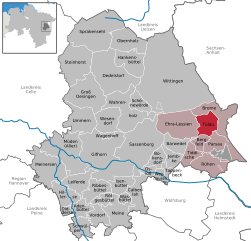
Tülau (Tülau)
- Municipality of Germany
Tülau is not widely recognized as a hiking destination, and there may be limited information available about specific trails or routes in that area. It's possible that you're referring to a lesser-known or local hiking spot, or it may be a misspelling of a more famous location.
If you are looking for hiking opportunities in a specific region, I can provide general advice on what to look for in a hiking area, such as trail difficulty, scenery, seasonality, and local regulations. Additionally, if Tülau is a local or emerging hiking destination, I recommend checking with local hiking clubs, tourism boards, or outdoor enthusiasts for the most current info on trails and conditions.
Alternatively, if you have a different location in mind, please provide more details, and I'd be happy to help you with specific hiking information!
- Country:

- Postal Code: 38474
- Local Dialing Code: 05833
- Licence Plate Code: GF
- Coordinates: 52° 34' 59" N, 10° 52' 0" E


- GPS tracks (wikiloc): [Link]
- AboveSeaLevel: 72 м m
- Area: 23.53 sq km
- Population: 1514
- Web site: https://www.tuelau.de
- Wikipedia en: wiki(en)
- Wikipedia: wiki(de)
- Wikidata storage: Wikidata: Q632631
- Wikipedia Commons Category: [Link]
- Freebase ID: [/m/02ry2lj]
- Freebase ID: [/m/02ry2lj]
- GeoNames ID: Alt: [2820822]
- GeoNames ID: Alt: [2820822]
- VIAF ID: Alt: [237471083]
- VIAF ID: Alt: [237471083]
- OSM relation ID: [1329929]
- OSM relation ID: [1329929]
- GND ID: Alt: [4765325-5]
- GND ID: Alt: [4765325-5]
- MusicBrainz area ID: [96b6d868-8ac2-462e-ab5e-3a0abfb6180f]
- MusicBrainz area ID: [96b6d868-8ac2-462e-ab5e-3a0abfb6180f]
- WOEID: [12630312]
- WOEID: [12630312]
- TGN ID: [7066035]
- TGN ID: [7066035]
- Historical Gazetteer (GOV) ID: [object_1131877]
- Historical Gazetteer (GOV) ID: [object_1131877]
- German municipality key: 03151032
- German municipality key: 03151032
Shares border with regions:


Parsau
- municipality in Germany
Parsau is a small village in Germany, located in the state of Lower Saxony. While it may not be as widely known for hiking as some other areas, the surrounding landscapes offer opportunities for nature walks and mild hiking excursions. Here are some points to consider if you're planning to hike in or near Parsau:...
- Country:

- Postal Code: 38470
- Local Dialing Code: 05368
- Licence Plate Code: GF
- Coordinates: 52° 31' 59" N, 10° 52' 0" E


- GPS tracks (wikiloc): [Link]
- AboveSeaLevel: 62 м m
- Area: 29.45 sq km
- Population: 1919
- Web site: [Link]


Bergfeld
- municipality of Germany
Bergfeld is a scenic area that offers a variety of hiking opportunities for outdoor enthusiasts. Nestled within beautiful landscapes, it typically features well-marked trails that cater to various skill levels, from beginners to more seasoned hikers....
- Country:

- Postal Code: 38467
- Local Dialing Code: 05368
- Licence Plate Code: GF
- Coordinates: 52° 32' 38" N, 10° 50' 42" E


- GPS tracks (wikiloc): [Link]
- AboveSeaLevel: 68 м m
- Area: 10.6 sq km
- Population: 898
- Web site: [Link]


Ehra-Lessien
- municipality of Germany
Ehra-Lessien is a small municipality located in Lower Saxony, Germany. While it may not be as well-known for hiking as some of the larger national parks or mountainous regions in Germany, there are still opportunities for outdoor activities in and around the area....
- Country:

- Postal Code: 38468
- Local Dialing Code: 05377
- Licence Plate Code: GF
- Coordinates: 52° 35' 49" N, 10° 47' 46" E


- GPS tracks (wikiloc): [Link]
- AboveSeaLevel: 63 м m
- Area: 56.08 sq km
- Population: 1931
- Web site: [Link]


Brome
- A district and municipality in Germany
Brome, located in Lower Saxony, Germany, is a charming town surrounded by scenic landscapes, making it an ideal spot for hiking enthusiasts. While Brome itself is a small community, its proximity to natural reserves and parks enhances the hiking experience in the region....
- Country:

- Postal Code: 38465
- Local Dialing Code: 05833
- Licence Plate Code: GF
- Coordinates: 52° 36' 0" N, 10° 57' 0" E


- GPS tracks (wikiloc): [Link]
- AboveSeaLevel: 72 м m
- Area: 36.66 sq km
- Population: 3400
- Web site: [Link]

