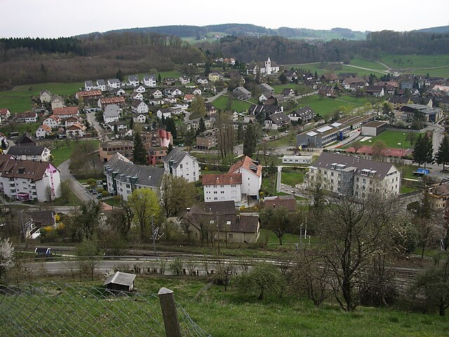
Berikon (Berikon)

- municipality in Switzerland
 Hiking in Berikon
Berikon is a picturesque town located in the canton of Aargau, Switzerland, and it offers a variety of hiking opportunities that appeal to both casual walkers and more experienced hikers. Here are some key points to consider when hiking in and around Berikon:
Hiking Trails
-
Scenic Views: Many trails in Berikon provide stunning views of the surrounding hills, forests, and even the distant Alps on clear days. The varied landscape makes for a beautiful hiking experience.
-
Difficulty Levels: There are trails suitable for all fitness levels, from easy walks for families to more challenging routes for experienced hikers looking for a workout.
-
Trail Markings: The hiking trails in the region are generally well-marked with signposts, making navigation straightforward. Be sure to have a good map or GPS device, especially if you plan to explore less official trails.
-
Network of Trails: Berikon is well connected to a broader network of hiking trails in Aargau, allowing for longer hikes that can take you into the surrounding natural areas, such as the nearby Reuss river and other scenic locales.
Nature and Wildlife
- The area around Berikon is rich in flora and fauna, providing opportunities to spot local wildlife. Be sure to respect the natural environment and follow the Leave No Trace principles.
Best Times to Hike
- Spring and Fall: These seasons usually offer the best weather for hiking, with mild temperatures and beautiful landscapes due to blooming flowers or fall foliage.
- Summer: Be prepared for warmer temperatures and take precautions against sun exposure and dehydration.
Preparing for Your Hike
-
Gear: Good hiking boots, water, snacks, and weather-appropriate clothing are essential. Depending on the season, you may also want trekking poles or extra layers for colder conditions.
-
Safety: Always let someone know your hiking plans and estimated return time. It's also wise to check the weather forecast before heading out.
-
Hiking Etiquette: Take care to keep noise levels down, yield to other hikers, and manage pets accordingly to preserve the peace and enjoyment of nature for everyone.
By following these guidelines, you can have an enjoyable and safe hiking experience in and around Berikon. Happy hiking!
- Country:

- Postal Code: 8965
- Local Dialing Code: 056
- Licence Plate Code: AG
- Coordinates: 47° 21' 14" N, 8° 23' 1" E


- GPS tracks (wikiloc): [Link]
- AboveSeaLevel: 583 м m
- Area: 5.38 sq km
- Population: 4715
- Web site: http://www.berikon.ch
- Wikipedia en: wiki(en)
- Wikipedia: wiki(de)
- Wikidata storage: Wikidata: Q64334
- Wikipedia Commons Category: [Link]
- Freebase ID: [/m/03y8wm]
- GeoNames ID: Alt: [7285208]
- VIAF ID: Alt: [247809948]
- OSM relation ID: [1684268]
- GND ID: Alt: [4362665-8]
- MusicBrainz area ID: [59000654-070d-4c67-8929-3ec9640db0fb]
- HDS ID: [1661]
- Swiss municipality code: [4062]
Shares border with regions:

Rudolfstetten-Friedlisberg
- municipality in Switzerland
Hiking in Rudolfstetten-Friedlisberg
Rudolfstetten-Friedlisberg is a picturesque municipality located in the Canton of Aargau in Switzerland. This area offers a variety of hiking opportunities, showcasing beautiful landscapes, lush forests, and stunning views of the surrounding hills and valleys....
- Country:
- Postal Code: 8964
- Local Dialing Code: 056
- Licence Plate Code: AG
- Coordinates: 47° 22' 9" N, 8° 22' 55" E
- GPS tracks (wikiloc): [Link]
- AboveSeaLevel: 479 м m
- Area: 4.90 sq km
- Population: 4466
- Web site: [Link]


Widen
- municipality in Switzerland
Hiking in Widen
Widen, located in the Canton of Aargau in Switzerland, offers beautiful hiking opportunities with its picturesque landscapes and well-marked trails. Here are some details to consider when planning a hike in Widen:...
- Country:
- Postal Code: 8967
- Local Dialing Code: 056
- Licence Plate Code: AG
- Coordinates: 47° 22' 12" N, 8° 21' 29" E
- GPS tracks (wikiloc): [Link]
- AboveSeaLevel: 562 м m
- Area: 2.62 sq km
- Population: 3668
- Web site: [Link]

Birmensdorf
- municipality in Switzerland
Hiking in Birmensdorf
Birmensdorf is a charming village situated near Zürich, Switzerland, that offers a variety of beautiful hiking opportunities. Nestled in the rolling hills of the Zurich region, this area provides access to scenic views and lush landscapes....
- Country:
- Postal Code: 8903
- Local Dialing Code: 044
- Licence Plate Code: ZH
- Coordinates: 47° 21' 14" N, 8° 26' 5" E
- GPS tracks (wikiloc): [Link]
- AboveSeaLevel: 463 м m
- Area: 11.38 sq km
- Population: 6385
- Web site: [Link]


Oberwil-Lieli
- municipality in the district of Bremgarten in the canton of Aargau in Switzerland
Hiking in Oberwil-Lieli
Oberwil-Lieli is a charming municipality in the canton of Aargau, Switzerland, known for its beautiful landscapes and outdoor recreational opportunities, including hiking. Here are some aspects to consider when hiking in and around Oberwil-Lieli:...
- Country:
- Postal Code: 8966
- Local Dialing Code: 056
- Licence Plate Code: AG
- Coordinates: 47° 20' 0" N, 8° 23' 0" E
- GPS tracks (wikiloc): [Link]
- AboveSeaLevel: 565 м m
- Area: 5.35 sq km
- Population: 2363
- Web site: [Link]