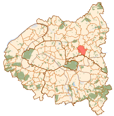
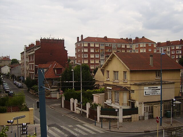
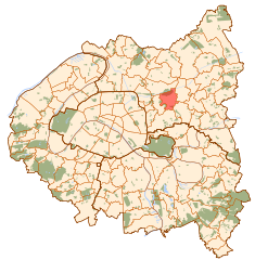
Bondy (Bondy)

- commune in Seine-Saint-Denis, France
- Country:

- Postal Code: 93140
- Licence Plate Code: 93
- Coordinates: 48° 54' 10" N, 2° 29' 1" E


- GPS tracks (wikiloc): [Link]
- AboveSeaLevel: 55 м m
- Area: 5.47 sq km
- Population: 53439
- Web site: http://www.ville-bondy.fr
- Wikipedia en: wiki(en)
- Wikipedia: wiki(fr)
- Wikidata storage: Wikidata: Q237394
- Wikipedia Commons Category: [Link]
- Wikipedia Commons Maps Category: [Link]
- Freebase ID: [/m/02kprr]
- Freebase ID: [/m/02kprr]
- Freebase ID: [/m/02kprr]
- Freebase ID: [/m/02kprr]
- GeoNames ID: Alt: [3031815]
- GeoNames ID: Alt: [3031815]
- GeoNames ID: Alt: [3031815]
- GeoNames ID: Alt: [3031815]
- SIREN number: [219300100]
- SIREN number: [219300100]
- SIREN number: [219300100]
- SIREN number: [219300100]
- BnF ID: [15280286z]
- BnF ID: [15280286z]
- BnF ID: [15280286z]
- BnF ID: [15280286z]
- VIAF ID: Alt: [125464177]
- VIAF ID: Alt: [125464177]
- VIAF ID: Alt: [125464177]
- VIAF ID: Alt: [125464177]
- GND ID: Alt: [4356819-1]
- GND ID: Alt: [4356819-1]
- GND ID: Alt: [4356819-1]
- GND ID: Alt: [4356819-1]
- Library of Congress authority ID: Alt: [n83225722]
- Library of Congress authority ID: Alt: [n83225722]
- Library of Congress authority ID: Alt: [n83225722]
- Library of Congress authority ID: Alt: [n83225722]
- MusicBrainz area ID: [8a624d02-d407-4424-b5a9-bcd8040ee5ca]
- MusicBrainz area ID: [8a624d02-d407-4424-b5a9-bcd8040ee5ca]
- MusicBrainz area ID: [8a624d02-d407-4424-b5a9-bcd8040ee5ca]
- MusicBrainz area ID: [8a624d02-d407-4424-b5a9-bcd8040ee5ca]
- Quora topic ID: [Bondy]
- Quora topic ID: [Bondy]
- Quora topic ID: [Bondy]
- Quora topic ID: [Bondy]
- Twitter username: Alt: [VilledeBondy]
- Twitter username: Alt: [VilledeBondy]
- Twitter username: Alt: [VilledeBondy]
- Twitter username: Alt: [VilledeBondy]
- INSEE municipality code: 93010
- INSEE municipality code: 93010
- INSEE municipality code: 93010
- INSEE municipality code: 93010
Shares border with regions:


Bobigny
- commune in Seine-Saint-Denis, France
- Country:
- Postal Code: 93000
- Coordinates: 48° 54' 35" N, 2° 26' 19" E
- GPS tracks (wikiloc): [Link]
- AboveSeaLevel: 45 м m
- Area: 6.77 sq km
- Population: 51716
- Web site: [Link]


Aulnay-sous-Bois
- commune in Seine-Saint-Denis, France
- Country:
- Postal Code: 93600
- Coordinates: 48° 56' 11" N, 2° 29' 35" E
- GPS tracks (wikiloc): [Link]
- Area: 16.2 sq km
- Population: 83584
- Web site: [Link]


Drancy
- commune in Seine-Saint-Denis, France
- Country:
- Postal Code: 93700
- Coordinates: 48° 55' 24" N, 2° 26' 42" E
- GPS tracks (wikiloc): [Link]
- AboveSeaLevel: 46 м m
- Area: 7.76 sq km
- Population: 69568
- Web site: [Link]


Le Blanc-Mesnil
- commune in Seine-Saint-Denis, France
- Country:
- Postal Code: 93150
- Coordinates: 48° 56' 19" N, 2° 27' 40" E
- GPS tracks (wikiloc): [Link]
- AboveSeaLevel: 40 м m
- Area: 8.05 sq km
- Population: 55297
- Web site: [Link]


Villemomble
- commune in Seine-Saint-Denis, France
- Country:
- Postal Code: 93250
- Coordinates: 48° 53' 25" N, 2° 30' 40" E
- GPS tracks (wikiloc): [Link]
- AboveSeaLevel: 58 м m
- Area: 4.04 sq km
- Population: 29847
- Web site: [Link]

Rosny-sous-Bois
- commune in Seine-Saint-Denis, France
- Country:
- Postal Code: 93110
- Coordinates: 48° 52' 23" N, 2° 29' 7" E
- GPS tracks (wikiloc): [Link]
- AboveSeaLevel: 69 м m
- Area: 5.91 sq km
- Population: 44728
- Web site: [Link]
Noisy-le-Sec
- commune in Seine-Saint-Denis, France
- Country:
- Postal Code: 93130
- Coordinates: 48° 53' 27" N, 2° 27' 13" E
- GPS tracks (wikiloc): [Link]
- AboveSeaLevel: 57 м m
- Area: 5.04 sq km
- Population: 43390
- Web site: [Link]


Les Pavillons-sous-Bois
- commune in Seine-Saint-Denis, France
- Country:
- Postal Code: 93320
- Coordinates: 48° 54' 21" N, 2° 30' 38" E
- GPS tracks (wikiloc): [Link]
- AboveSeaLevel: 55 м m
- Area: 2.92 sq km
- Population: 23356
- Web site: [Link]