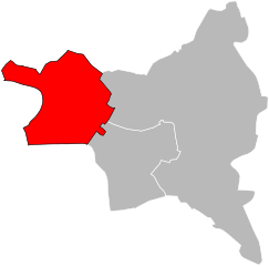
arrondissement of Bobigny (arrondissement de Bobigny)
- arrondissement of France
- Country:

- Capital: Bobigny
- Coordinates: 48° 54' 25" N, 2° 26' 22" E


- GPS tracks (wikiloc): [Link]
- Population: 412972
- Wikipedia en: wiki(en)
- Wikipedia: wiki(fr)
- Wikidata storage: Wikidata: Q700686
- Freebase ID: [/m/08rclv]
- GeoNames ID: Alt: [6457371]
- INSEE arrondissement code: [931]
Includes regions:


canton of Drancy
- canton of France
- Country:

- Capital: Drancy
- Coordinates: 48° 56' 0" N, 2° 27' 0" E


- GPS tracks (wikiloc): [Link]
- Population: 62146

canton of Noisy-le-Sec
- canton of France (until March 2015)
- Country:

- Capital: Noisy-le-Sec
- Coordinates: 48° 53' 0" N, 2° 28' 0" E


- GPS tracks (wikiloc): [Link]


canton of Bagnolet
- canton of France
- Country:

- Capital: Bagnolet
- Coordinates: 48° 52' 0" N, 2° 25' 0" E


- GPS tracks (wikiloc): [Link]
- Population: 84876

canton of Pavillons-sous-Bois
- canton of France (until March 2015)
- Country:

- Capital: Les Pavillons-sous-Bois
- Coordinates: 48° 54' 0" N, 2° 31' 0" E


- GPS tracks (wikiloc): [Link]

canton of Rosny-sous-Bois
- canton of France (until March 2015)
- Country:

- Capital: Rosny-sous-Bois
- Coordinates: 48° 52' 0" N, 2° 29' 0" E


- GPS tracks (wikiloc): [Link]

canton of Le Bourget
- canton of France (until March 2015)
- Country:

- Capital: Le Bourget
- Coordinates: 48° 56' 0" N, 2° 25' 0" E


- GPS tracks (wikiloc): [Link]


canton of Villemomble
- canton of France
- Country:

- Capital: Villemomble
- Coordinates: 48° 53' 0" N, 2° 30' 0" E


- GPS tracks (wikiloc): [Link]
- Population: 65423


Bondy
- commune in Seine-Saint-Denis, France
- Country:

- Postal Code: 93140
- Licence Plate Code: 93
- Coordinates: 48° 54' 10" N, 2° 29' 1" E


- GPS tracks (wikiloc): [Link]
- AboveSeaLevel: 55 м m
- Area: 5.47 sq km
- Population: 53439
- Web site: [Link]

canton of Romainville
- canton of France (until March 2015)
- Country:

- Capital: Romainville
- Coordinates: 48° 53' 0" N, 2° 26' 0" E


- GPS tracks (wikiloc): [Link]


canton of Bobigny
- canton of France
- Country:

- Capital: Bobigny
- Coordinates: 48° 54' 0" N, 2° 27' 0" E


- GPS tracks (wikiloc): [Link]
- Population: 92428
Shares border with regions:


arrondissement of Saint-Denis, Seine-Saint-Denis
- arrondissement of France in Île-de-France
- Country:

- Capital: Saint-Denis
- Coordinates: 48° 56' 1" N, 2° 21' 23" E


- GPS tracks (wikiloc): [Link]
- Area: 47 sq km
- Population: 429266


arrondissement of Le Raincy
- arrondissement of France
- Country:

- Capital: Le Raincy
- Coordinates: 48° 53' 52" N, 2° 31' 11" E


- GPS tracks (wikiloc): [Link]
- Area: 123 sq km
- Population: 750425

arrondissement of Nogent-sur-Marne
- arrondissement of France
- Country:

- Capital: Nogent-sur-Marne
- Coordinates: 48° 50' 11" N, 2° 28' 44" E


- GPS tracks (wikiloc): [Link]
- Area: 63 sq km
- Population: 396606


