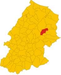
Bonefro (Bonefro)
.svg)
- Italian comune
 Hiking in Bonefro
Bonefro, a small town located in the province of Campobasso in the Molise region of Italy, offers beautiful hiking opportunities amidst a rich natural landscape. Here are some highlights for hiking in and around Bonefro:
Trails and Natural Features
-
Local Trails: The area around Bonefro is characterized by rolling hills, lush forests, and stunning views of the surrounding countryside. Various trails are available for different skill levels, ranging from easy walks to more challenging treks.
-
Bonefro Lake: This is a popular spot for hikers and nature lovers. The lake area offers picturesque views and is a great place for a leisurely hike or a picnic. The surrounding natural environment provides opportunities for birdwatching and enjoying local flora.
-
Nature Reserves: The nearby natural reserves such as the "Riserva Naturale di Montedimezzo" feature various trails that allow hikers to experience the diverse wildlife and plant species of the region.
Hiking Tips
- Preparation: Make sure to wear appropriate hiking shoes and bring enough water, especially during the warmer months. A map is also useful as trails may not be well-marked in some areas.
- Local Guides: Consider hiring a local guide if you're unfamiliar with the area. They can provide insights into the region’s history and ecology.
- Respect Nature: As with all hiking activities, it’s essential to practice Leave No Trace principles. Keep to marked trails, and be mindful of wildlife and local ecosystems.
Things to Consider
- Weather: The weather can vary, so check forecasts and be prepared for sudden changes. Spring and autumn are particularly pleasant for hiking.
- Cultural Sites: After hiking, take time to explore the town of Bonefro itself, which has historical sites and charming architecture worth visiting.
Hiking in Bonefro offers a mix of natural beauty, adventure, and cultural experiences, making it a wonderful destination for outdoor enthusiasts.
- Country:

- Postal Code: 86041
- Local Dialing Code: 0874
- Licence Plate Code: CB
- Coordinates: 41° 42' 15" N, 14° 56' 9" E


- GPS tracks (wikiloc): [Link]
- AboveSeaLevel: 631 м m
- Area: 31.28 sq km
- Population: 1331
- Web site: http://www.comune.bonefro.cb.it/
- Wikipedia en: wiki(en)
- Wikipedia: wiki(it)
- Wikidata storage: Wikidata: Q277378
- Wikipedia Commons Category: [Link]
- Freebase ID: [/m/0gnng9]
- GeoNames ID: Alt: [6538898]
- VIAF ID: Alt: [127862952]
- OSM relation ID: [41486]
- UN/LOCODE: [ITBFO]
- ISTAT ID: 070004
- Italian cadastre code: A971
Shares border with regions:
Sant’Elia a Pianisi
- Italian comune
Hiking in Sant’Elia a Pianisi
Sant'Elia a Pianisi is a charming town located in the Molise region of Italy. While it may not be the most famous hiking destination, it offers a beautiful natural landscape and some opportunities for outdoor activities. If you're interested in hiking in this area, here are some insights:...
- Country:
- Postal Code: 86048
- Local Dialing Code: 0874
- Licence Plate Code: CB
- Coordinates: 41° 37' 17" N, 14° 52' 34" E
- GPS tracks (wikiloc): [Link]
- AboveSeaLevel: 666 м m
- Area: 68.25 sq km
- Population: 1732
- Web site: [Link]
Ripabottoni
- Italian comune
Hiking in Ripabottoni
Ripabottoni is a small town located in the Molise region of Italy, surrounded by the beautiful Apennine Mountains and lush countryside, making it an excellent destination for hiking enthusiasts. Here are some key points to consider when planning a hiking trip in Ripabottoni:...
- Country:
- Postal Code: 86040
- Local Dialing Code: 0874
- Licence Plate Code: CB
- Coordinates: 41° 41' 0" N, 14° 49' 0" E
- GPS tracks (wikiloc): [Link]
- AboveSeaLevel: 695 м m
- Area: 31.96 sq km
- Population: 531
- Web site: [Link]


Casacalenda
- Italian comune
Hiking in Casacalenda
Casacalenda is a charming village located in the Molise region of Italy, surrounded by beautiful landscapes that are ideal for hiking enthusiasts. The area is characterized by its rolling hills, lush greenery, and a mix of natural and cultural attractions. Here are some highlights for hiking in and around Casacalenda:...
- Country:
- Postal Code: 86043
- Local Dialing Code: 0874
- Licence Plate Code: CB
- Coordinates: 41° 44' 29" N, 14° 50' 56" E
- GPS tracks (wikiloc): [Link]
- AboveSeaLevel: 670 м m
- Area: 67.28 sq km
- Population: 2049
- Web site: [Link]


Montelongo
- Italian comune
Hiking in Montelongo
Montelongo, located in Italy's Abruzzo region, offers a unique hiking experience with its picturesque landscapes, rich history, and diverse flora and fauna. While it may not be as widely known as some other hiking destinations, it provides beautiful trails that enjoy breathtaking views of the surrounding mountains and valleys....
- Country:
- Postal Code: 86040
- Local Dialing Code: 0874
- Licence Plate Code: CB
- Coordinates: 41° 44' 13" N, 14° 57' 1" E
- GPS tracks (wikiloc): [Link]
- AboveSeaLevel: 592 м m
- Area: 12.76 sq km
- Population: 357
- Web site: [Link]

Montorio nei Frentani
- Italian comune
Hiking in Montorio nei Frentani
Montorio nei Frentani is a charming village in the Molise region of Italy, known for its picturesque landscapes and historical significance. Hiking in this area offers a blend of natural beauty, scenic views, and cultural experiences. Here are some highlights and tips for hiking in and around Montorio nei Frentani:...
- Country:
- Postal Code: 86040
- Local Dialing Code: 0874
- Licence Plate Code: CB
- Coordinates: 41° 45' 34" N, 14° 55' 58" E
- GPS tracks (wikiloc): [Link]
- AboveSeaLevel: 654 м m
- Area: 31.66 sq km
- Population: 403
- Web site: [Link]


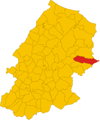
San Giuliano di Puglia
- Italian comune
Hiking in San Giuliano di Puglia
San Giuliano di Puglia is a small town located in the Molise region of Italy, surrounded by picturesque landscapes that are ideal for hiking and outdoor activities. While San Giuliano itself is not a widely known hiking destination, its proximity to the Apennine Mountains and the surrounding countryside offers several opportunities for nature lovers and hikers....
- Country:
- Postal Code: 86040
- Local Dialing Code: 0874
- Licence Plate Code: CB
- Coordinates: 41° 41' 0" N, 14° 58' 0" E
- GPS tracks (wikiloc): [Link]
- AboveSeaLevel: 890 м m
- Area: 42.05 sq km
- Population: 1024
- Web site: [Link]

Santa Croce di Magliano
- Italian comune
Hiking in Santa Croce di Magliano
Santa Croce di Magliano is a charming town located in the Molise region of Italy, known for its scenic landscapes and rich history. Hiking in this area offers a unique opportunity to explore the natural beauty and cultural heritage of the region....
- Country:
- Postal Code: 86047
- Local Dialing Code: 0874
- Licence Plate Code: CB
- Coordinates: 41° 43' 0" N, 14° 59' 0" E
- GPS tracks (wikiloc): [Link]
- AboveSeaLevel: 608 м m
- Area: 53.37 sq km
- Population: 4345
- Web site: [Link]