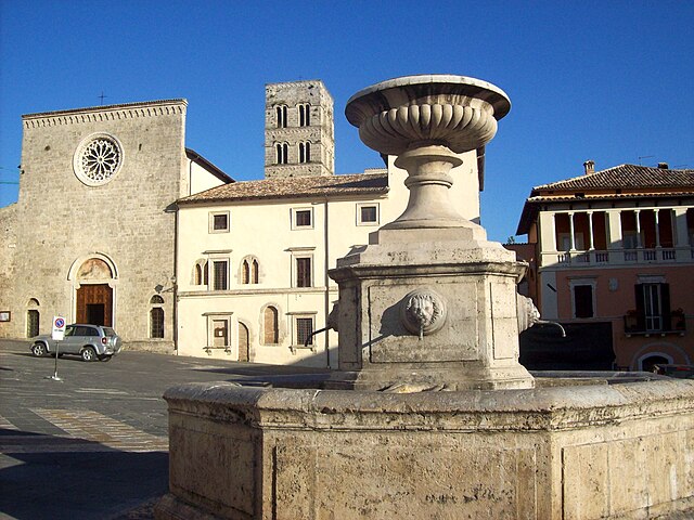
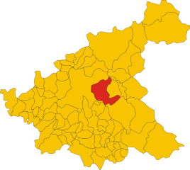
Borgo Velino (Borgo Velino)
.svg)
- Italian comune
 Hiking in Borgo Velino
Borgo Velino is a charming village located in the province of Rieti in the Lazio region of Italy. Nestled among the foothills of the Apennines, it offers stunning landscapes and diverse hiking opportunities. Here are some highlights for hiking in and around Borgo Velino:
Hiking Trails
-
Monti della Laga National Park: Just a short distance from Borgo Velino, this national park features numerous trails ranging from easy walks to more challenging hikes. The park is known for its rugged terrain, lush forests, and picturesque views.
-
Cascata delle Marmore: While technically a drive away from Borgo Velino, this spectacular waterfall offers nearby hiking trails that lead to viewpoints and along the river. It’s a great place to combine a visit with hiking opportunities.
-
Local Trails: The area around Borgo Velino has various local trails that wind through olive groves, vineyards, and traditional countryside. These trails can offer a leisurely experience for those looking to enjoy the local flora and fauna.
What to Prepare
- Footwear: Sturdy hiking boots with good ankle support are recommended due to the varied terrain.
- Clothing: Dress in layers, as temperatures can vary significantly. Lightweight, moisture-wicking fabrics are ideal.
- Navigation: It’s helpful to carry a map or a GPS device, as some trails may not be well-marked.
- Water and Snacks: Always carry enough water and some high-energy snacks, especially for longer hikes.
- Safety: Inform someone about your hiking plans and estimated return time. It’s also wise to check the weather forecast before heading out.
Best Time to Hike
Spring (April-May) and Autumn (September-October) are ideal for hiking in Borgo Velino due to mild temperatures and beautiful natural scenery. Summer can be hot, while winters may bring snow, particularly in higher elevations, which can affect trail accessibility.
Cultural Aspects
While hiking, take the time to appreciate the local culture. Borgo Velino is known for its historical architecture and local cuisine. Consider stopping in the village for a meal or to explore its quaint streets after a day of hiking.
Conclusion
Borgo Velino offers a delightful blend of nature, culture, and adventure. Whether you are an experienced hiker or a beginner, the area provides great opportunities to enjoy the beauty of the Italian countryside. Make sure to respect the natural environment and enjoy your hike!
- Country:

- Postal Code: 02010
- Local Dialing Code: 0746
- Licence Plate Code: RI
- Coordinates: 42° 24' 0" N, 13° 4' 0" E


- GPS tracks (wikiloc): [Link]
- AboveSeaLevel: 460 м m
- Area: 18.29 sq km
- Population: 941
- Web site: http://www.comune.borgotossignano.bo.it
- Wikipedia en: wiki(en)
- Wikipedia: wiki(it)
- Wikidata storage: Wikidata: Q223472
- Wikipedia Commons Category: [Link]
- Freebase ID: [/m/0gm4zd]
- GeoNames ID: Alt: [6541126]
- VIAF ID: Alt: [236181288]
- OSM relation ID: [41994]
- Quora topic ID: [Borgo-Velino]
- ISTAT ID: 057008
- Italian cadastre code: A996
Shares border with regions:
Fiamignano
- Italian comune
Hiking in Fiamignano
Fiamignano, a picturesque village in the province of Rieti in Italy, is surrounded by beautiful landscapes and offers numerous hiking opportunities. Situated in the heart of the Apennines, hiking in this region provides stunning views, diverse flora and fauna, and a chance to explore local culture and history....
- Country:
- Postal Code: 02023
- Local Dialing Code: 0746
- Licence Plate Code: RI
- Coordinates: 42° 16' 0" N, 13° 8' 0" E
- GPS tracks (wikiloc): [Link]
- AboveSeaLevel: 988 м m
- Area: 100.62 sq km
- Population: 1337
- Web site: [Link]


Antrodoco
- Italian comune
Hiking in Antrodoco
Antrodoco, a town located in the province of Rieti in central Italy, is situated in the Apennine mountain range and offers beautiful hiking opportunities. This area is characterized by its stunning natural landscapes, charming villages, and rich cultural heritage....
- Country:
- Postal Code: 02013
- Local Dialing Code: 0746
- Licence Plate Code: RI
- Coordinates: 42° 25' 0" N, 13° 5' 0" E
- GPS tracks (wikiloc): [Link]
- AboveSeaLevel: 525 м m
- Area: 63.9 sq km
- Population: 2498
- Web site: [Link]


Castel Sant’Angelo
- Italian comune
Hiking in Castel Sant’Angelo
Hiking around Castel Sant'Angelo, located in Rome, Lazio, offers a unique blend of historical exploration and urban walking. While the area directly surrounding Castel Sant'Angelo is more about leisurely strolls and sightseeing than traditional hiking, there are several nearby opportunities for those looking to incorporate some nature walks or hiking into their visit....
- Country:
- Postal Code: 02010
- Local Dialing Code: 0746
- Licence Plate Code: RI
- Coordinates: 42° 24' 0" N, 13° 1' 0" E
- GPS tracks (wikiloc): [Link]
- AboveSeaLevel: 448 м m
- Area: 31.27 sq km
- Population: 1302
- Web site: [Link]
Cittaducale
- Italian comune
Hiking in Cittaducale
Cittaducale, located in the province of Rieti in Italy, is a charming town that offers beautiful landscapes and natural surroundings, making it a great destination for hiking enthusiasts. The area is characterized by its rolling hills, picturesque valleys, and proximity to the awe-inspiring Apennine mountains....
- Country:
- Postal Code: 02015
- Local Dialing Code: 0746
- Licence Plate Code: RI
- Coordinates: 42° 23' 0" N, 12° 57' 0" E
- GPS tracks (wikiloc): [Link]
- AboveSeaLevel: 481 м m
- Area: 71.25 sq km
- Population: 6719
- Web site: [Link]
Micigliano
- Italian comune
Hiking in Micigliano
Micigliano is a charming village located in the province of Rieti in the Lazio region of Italy. Nestled in the Sabina hills, it offers picturesque landscapes and a tranquil environment, making it a great destination for hiking enthusiasts....
- Country:
- Postal Code: 02010
- Local Dialing Code: 0746
- Licence Plate Code: RI
- Coordinates: 42° 27' 0" N, 13° 3' 0" E
- GPS tracks (wikiloc): [Link]
- AboveSeaLevel: 925 м m
- Area: 36.85 sq km
- Population: 133
- Web site: [Link]


Petrella Salto
- Italian comune
Hiking in Petrella Salto
Petrella Salto is a charming village nestled in the Lazio region of Italy, surrounded by beautiful landscapes and rich natural beauty, making it an excellent destination for hiking enthusiasts. Here are some aspects to consider if you're thinking about hiking in this area:...
- Country:
- Postal Code: 02025
- Local Dialing Code: 0746
- Licence Plate Code: RI
- Coordinates: 42° 18' 0" N, 13° 4' 0" E
- GPS tracks (wikiloc): [Link]
- AboveSeaLevel: 786 м m
- Area: 102.93 sq km
- Population: 1146
- Web site: [Link]