Fiamignano (Fiamignano)
.svg)
- Italian comune
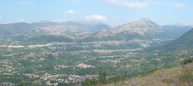
 Hiking in Fiamignano
Fiamignano, a picturesque village in the province of Rieti in Italy, is surrounded by beautiful landscapes and offers numerous hiking opportunities. Situated in the heart of the Apennines, hiking in this region provides stunning views, diverse flora and fauna, and a chance to explore local culture and history.
Hiking Trails:
-
Sentiero del Fiume Aterno: This trail follows the Aterno River and offers a relatively easy hike suitable for families. You'll encounter beautiful river views and the chance to see local wildlife.
-
Monte Giano: For a more challenging hike, consider the trails leading up to Monte Giano. The climb rewards hikers with panoramic views of the surrounding valleys and mountains.
-
Parco Regionale dei Monti Simbruini: Located nearby, this regional park offers numerous trails of varying difficulty levels. Hiking here allows you to explore deep forests, rocky outcrops, and potentially spot some of the local wildlife, like deer and various bird species.
Preparation:
- Weather: Always check the weather forecast before heading out, as conditions can change quickly in the mountains.
- Gear: Wear comfortable hiking boots and carry essentials like water, snacks, a first aid kit, and a map or GPS device.
- Local Guides: If you're unfamiliar with the area, consider hiring a local guide who can provide insights into the natural beauty and historical significance of the trails.
Cultural Aspects:
While hiking in Fiamignano, take the opportunity to explore the village itself. The region is rich in history, and you might encounter ancient ruins, churches, and traditional Italian architecture along your hikes.
Safety Tips:
- Always inform someone about your hiking plans and expected return time.
- Hike with a buddy if possible, especially in more remote areas.
- Respect local wildlife and flora to preserve the natural environment.
Overall, hiking in Fiamignano can be a rewarding experience filled with natural beauty, physical challenge, and cultural enrichment. Enjoy your adventure!
- Country:

- Postal Code: 02023
- Local Dialing Code: 0746
- Licence Plate Code: RI
- Coordinates: 42° 16' 0" N, 13° 8' 0" E


- GPS tracks (wikiloc): [Link]
- AboveSeaLevel: 988 м m
- Area: 100.62 sq km
- Population: 1337
- Web site: http://www.comune.fiamignano.ri.it/
- Wikipedia en: wiki(en)
- Wikipedia: wiki(it)
- Wikidata storage: Wikidata: Q204106
- Wikipedia Commons Category: [Link]
- Freebase ID: [/m/0gm5g4]
- GeoNames ID: Alt: [6539754]
- VIAF ID: Alt: [246351197]
- OSM relation ID: [41927]
- WOEID: [715418]
- ISTAT ID: 057028
- Italian cadastre code: D560
Shares border with regions:


Antrodoco
- Italian comune
Hiking in Antrodoco
Antrodoco, a town located in the province of Rieti in central Italy, is situated in the Apennine mountain range and offers beautiful hiking opportunities. This area is characterized by its stunning natural landscapes, charming villages, and rich cultural heritage....
- Country:
- Postal Code: 02013
- Local Dialing Code: 0746
- Licence Plate Code: RI
- Coordinates: 42° 25' 0" N, 13° 5' 0" E
- GPS tracks (wikiloc): [Link]
- AboveSeaLevel: 525 м m
- Area: 63.9 sq km
- Population: 2498
- Web site: [Link]
Borgo Velino
- Italian comune
Hiking in Borgo Velino
Borgo Velino is a charming village located in the province of Rieti in the Lazio region of Italy. Nestled among the foothills of the Apennines, it offers stunning landscapes and diverse hiking opportunities. Here are some highlights for hiking in and around Borgo Velino:...
- Country:
- Postal Code: 02010
- Local Dialing Code: 0746
- Licence Plate Code: RI
- Coordinates: 42° 24' 0" N, 13° 4' 0" E
- GPS tracks (wikiloc): [Link]
- AboveSeaLevel: 460 м m
- Area: 18.29 sq km
- Population: 941
- Web site: [Link]
Borgorose
- Italian comune
Hiking in Borgorose
Borgorose is a beautiful destination for hiking enthusiasts, located in the Abruzzo region of Italy. It's surrounded by stunning natural landscapes, including mountains, forests, and rivers, making it an appealing spot for outdoor activities....
- Country:
- Postal Code: 02021
- Local Dialing Code: 0746
- Licence Plate Code: RI
- Coordinates: 42° 12' 0" N, 13° 14' 0" E
- GPS tracks (wikiloc): [Link]
- AboveSeaLevel: 732 м m
- Area: 145.82 sq km
- Population: 4486
- Web site: [Link]


Pescorocchiano
- Italian comune
Hiking in Pescorocchiano
Pescorocchiano is a charming village located in the province of Rieti in the Lazio region of Italy. It serves as an excellent base for hikers who want to explore the surrounding natural beauty and historical sites. The area is characterized by lush landscapes, rolling hills, and picturesque views, making it a fantastic destination for outdoor enthusiasts....
- Country:
- Postal Code: 02024
- Local Dialing Code: 0746
- Licence Plate Code: RI
- Coordinates: 42° 12' 0" N, 13° 9' 0" E
- GPS tracks (wikiloc): [Link]
- AboveSeaLevel: 806 м m
- Area: 94.78 sq km
- Population: 2050
- Web site: [Link]


Petrella Salto
- Italian comune
Hiking in Petrella Salto
Petrella Salto is a charming village nestled in the Lazio region of Italy, surrounded by beautiful landscapes and rich natural beauty, making it an excellent destination for hiking enthusiasts. Here are some aspects to consider if you're thinking about hiking in this area:...
- Country:
- Postal Code: 02025
- Local Dialing Code: 0746
- Licence Plate Code: RI
- Coordinates: 42° 18' 0" N, 13° 4' 0" E
- GPS tracks (wikiloc): [Link]
- AboveSeaLevel: 786 м m
- Area: 102.93 sq km
- Population: 1146
- Web site: [Link]
Scoppito
- Italian comune
Hiking in Scoppito
Scoppito is a charming village located in the province of L'Aquila in Abruzzo, Italy. Surrounded by the natural beauty of the Apennine Mountains, it offers a variety of hiking opportunities for both novice and experienced hikers. The area's diverse terrain includes mountainous landscapes, woodlands, and beautiful valleys, providing a range of trails suitable for exploration....
- Country:
- Postal Code: 67019
- Local Dialing Code: 0862
- Licence Plate Code: AQ
- Coordinates: 42° 22' 26" N, 13° 15' 21" E
- GPS tracks (wikiloc): [Link]
- AboveSeaLevel: 820 м m
- Area: 53 sq km
- Population: 3805
- Web site: [Link]

Tornimparte
- Italian comune
Hiking in Tornimparte
Tornimparte is a picturesque village located in the province of Ávila, in the autonomous community of Castilla y León, Spain. Nestled in the Sierra de Villafranca, it provides access to beautiful natural landscapes and several hiking opportunities....
- Country:
- Postal Code: 67049
- Local Dialing Code: 0862
- Licence Plate Code: AQ
- Coordinates: 42° 17' 24" N, 13° 18' 3" E
- GPS tracks (wikiloc): [Link]
- AboveSeaLevel: 830 м m
- Area: 65.96 sq km
- Population: 3152
- Web site: [Link]