Borgomaro (Borgomaro)
- Italian comune
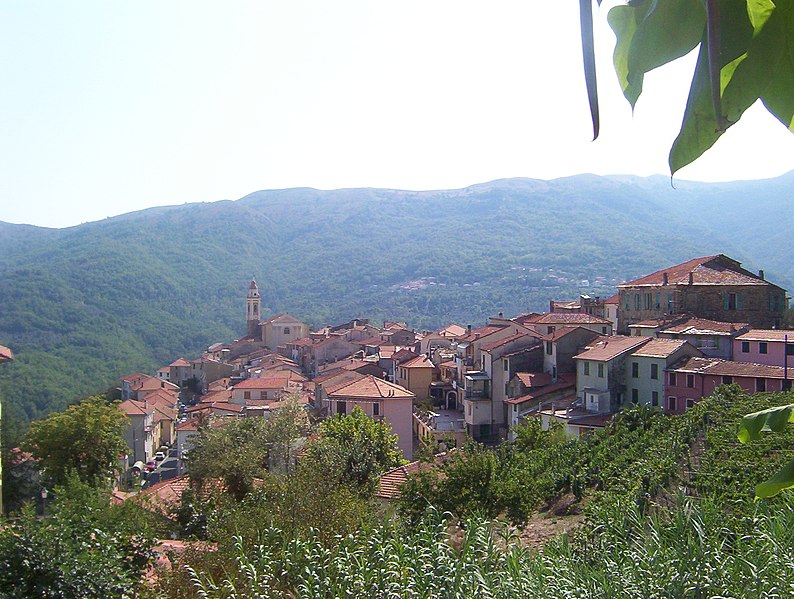
Borgomaro is a picturesque village located in the Liguria region of Italy, nestled in the foothills of the Maritime Alps. The area offers beautiful hiking opportunities, featuring lush landscapes, charming villages, and stunning views of the surrounding mountains and valleys.
Hiking Trails
-
Borgomaro to Candeasco: This trail takes you through beautiful olive groves and offers stunning views of the surrounding hills. It's a moderate hike, suitable for most levels of hikers.
-
Valle Argentina: Explore the trails that extend into the Valle Argentina, which is known for its natural beauty and diverse flora. The trails vary in difficulty, catering to both beginners and experienced hikers.
-
Monte Grande: For those looking for a challenge, the hike to Monte Grande will reward you with panoramic views of the Ligurian coastline. The trail can be steep in sections, so good fitness and preparation are essential.
Tips for Hiking in Borgomaro
- Planning: Make sure to check the weather conditions before you head out, as they can change rapidly in mountainous areas.
- Equipment: Wear appropriate hiking boots, and consider bringing trekking poles for stability, especially on steep or uneven terrain.
- Water and Snacks: Bring enough water and energy snacks, as some trails may not have facilities nearby.
- Trail Maps: Carry a printed map or have a navigation app ready, as cell service can be spotty in some areas.
- Local Guidance: If you're unfamiliar with the area, consider joining a guided hiking tour. Local guides can offer insights into the flora, fauna, and history of the region.
Seasonality
The best time to hike in Borgomaro is during the spring (April to June) and fall (September to October) when the weather is mild and the scenery is particularly beautiful with wildflowers blooming or autumn colors.
Conclusion
Borgomaro provides a unique hiking experience that combines natural beauty with cultural heritage. Whether you're a novice or an experienced hiker, the trails around Borgomaro offer something for everyone. Always prioritize safety, respect nature, and enjoy the breathtaking views that this lovely Italian region has to offer!
- Country:

- Postal Code: 18021
- Local Dialing Code: 0183
- Licence Plate Code: IM
- Coordinates: 43° 58' 32" N, 7° 56' 41" E


- GPS tracks (wikiloc): [Link]
- AboveSeaLevel: 200 м m
- Area: 23.44 sq km
- Population: 881
- Web site: http://www.comune.borgomaro.im.it
- Wikipedia en: wiki(en)
- Wikipedia: wiki(it)
- Wikidata storage: Wikidata: Q268246
- Wikipedia Commons Category: [Link]
- Freebase ID: [/m/0gby8m]
- GeoNames ID: Alt: [6540549]
- OSM relation ID: [42768]
- WOEID: [711249]
- ISTAT ID: 008010
- Italian cadastre code: B020
Shares border with regions:


Aurigo
- Italian comune
Aurigo is a charming village located in the Liguria region of Italy, specifically in the province of Imperia. Nestled in the hills of the Italian Riviera, Aurigo offers stunning landscapes, lush greenery, and picturesque views of the surrounding countryside and coastline....
- Country:

- Postal Code: 18020
- Local Dialing Code: 0183
- Licence Plate Code: IM
- Coordinates: 43° 58' 58" N, 7° 55' 22" E


- GPS tracks (wikiloc): [Link]
- AboveSeaLevel: 431 м m
- Area: 9.14 sq km
- Population: 337
- Web site: [Link]


Caravonica
- Italian comune
Caravonica, located in Queensland, Australia, is a charming area near Cairns that offers various hiking opportunities, particularly in the surrounding natural landscapes. Here are some key points to consider for hiking in Caravonica:...
- Country:

- Postal Code: 18020
- Local Dialing Code: 0183
- Licence Plate Code: IM
- Coordinates: 43° 59' 32" N, 7° 57' 31" E


- GPS tracks (wikiloc): [Link]
- AboveSeaLevel: 360 м m
- Area: 4.47 sq km
- Population: 266
- Web site: [Link]


Chiusanico
- Italian comune
Chiusanico is a picturesque village located in the Liguria region of Italy, near the stunning coastline of the Italian Riviera. The area offers various hiking opportunities that cater to different skill levels, with trails that showcase the natural beauty of the region, including hills, vineyards, olive groves, and breathtaking views of the Ligurian Sea....
- Country:

- Postal Code: 18027
- Local Dialing Code: 0183
- Licence Plate Code: IM
- Coordinates: 43° 58' 16" N, 7° 59' 36" E


- GPS tracks (wikiloc): [Link]
- AboveSeaLevel: 380 м m
- Area: 13.51 sq km
- Population: 578
- Web site: [Link]


Lucinasco
- Italian comune
Lucinasco is a charming village located in the province of Imperia in the Liguria region of Italy. Nestled in the hills above the coastline, it offers stunning views of the surrounding landscape, making it an excellent destination for hiking enthusiasts. Here are some key points about hiking in and around Lucinasco:...
- Country:

- Postal Code: 18020
- Local Dialing Code: 0183
- Licence Plate Code: IM
- Coordinates: 43° 58' 4" N, 7° 57' 46" E


- GPS tracks (wikiloc): [Link]
- AboveSeaLevel: 499 м m
- Area: 7.9 sq km
- Population: 283
- Web site: [Link]


Pieve di Teco
- Italian comune
Pieve di Teco, located in the region of Liguria in northern Italy, offers a picturesque setting for hiking enthusiasts. This charming village, nestled in the Valle Arroscia, is surrounded by stunning landscapes, including rolling hills, terraced vineyards, and lush woodlands....
- Country:

- Postal Code: 18026
- Local Dialing Code: 0183
- Licence Plate Code: IM
- Coordinates: 44° 2' 53" N, 7° 54' 58" E


- GPS tracks (wikiloc): [Link]
- AboveSeaLevel: 240 м m
- Area: 40.51 sq km
- Population: 1339
- Web site: [Link]


Prelà
- Italian comune
Prelà is a charming village located in the Liguria region of Italy, known for its lush landscapes and proximity to the beautiful Italian Riviera. Hiking in and around Prelà offers a range of experiences, from gentle walks through olive groves to more challenging trails with stunning views of the surrounding mountains and coastline....
- Country:

- Postal Code: 18020
- Local Dialing Code: 0183
- Licence Plate Code: IM
- Coordinates: 43° 55' 26" N, 7° 54' 33" E


- GPS tracks (wikiloc): [Link]
- AboveSeaLevel: 151 м m
- Area: 14.8 sq km
- Population: 498
- Web site: [Link]


Rezzo
- Italian comune
Rezzo is a charming village located in the Italian region of Liguria, surrounded by the beautiful landscapes of the Maritime Alps. Hiking in and around Rezzo offers a fantastic way to explore the natural beauty of the area, with stunning views, diverse flora and fauna, and a rich cultural heritage....
- Country:

- Postal Code: 18026
- Local Dialing Code: 0183
- Licence Plate Code: IM
- Coordinates: 44° 1' 16" N, 7° 52' 19" E


- GPS tracks (wikiloc): [Link]
- AboveSeaLevel: 563 м m
- Area: 37.37 sq km
- Population: 339
- Web site: [Link]


Vasia
- Italian comune
Vasia, located in the Liguria region of Italy, is a charming destination for hikers looking to explore picturesque landscapes and enjoy the serenity of nature. The area offers a variety of trails suitable for different skill levels, ranging from leisurely walks to more challenging hikes....
- Country:

- Postal Code: 18020
- Local Dialing Code: 0183
- Licence Plate Code: IM
- Coordinates: 43° 56' 0" N, 7° 57' 16" E


- GPS tracks (wikiloc): [Link]
- AboveSeaLevel: 385 м m
- Area: 11.15 sq km
- Population: 405
- Web site: [Link]

