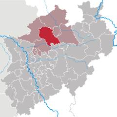
Borken (Kreis Borken)

- German district of North Rhine-Westphalia
 Hiking in Borken
Borken is a district located in North Rhine-Westphalia, Germany, and it offers a variety of hiking opportunities for outdoor enthusiasts. The region is characterized by its diverse landscapes, which include forests, meadows, rivers, and a mix of natural and agricultural areas.
Here are some notable aspects of hiking in Borken:
1.
- Hiking Trails: Borken has an extensive network of marked hiking trails. These trails cater to different skill levels, from easy walks to more challenging hikes. Popular trails include circular routes that allow hikers to explore the scenic beauty of the area.
- Local Guides: Consider joining guided hikes that provide insights into the local flora, fauna, and history. Local hiking clubs often organize group hikes.
2.
- Parks and Nature Reserves: There are several parks and protected areas where you can enjoy hiking while experiencing the local flora and fauna, such as the Hohe Mark Nature Park, which offers well-marked trails and beautiful scenery.
- Rivers and Streams: Hiking along the areas littered with rivers like the Aa and the Berkel provides picturesque views and tranquil settings.
3.
- Borken is also rich in history, and many hiking routes can lead you to interesting cultural sites such as castles, churches, and traditional villages. Hiking is a great way to explore the local heritage.
4.
- The district is well connected by transportation, making it easy to access starting points for various hiking trails. Many trails have facilities such as rest areas, information boards, and nearby cafés or restaurants.
5.
- Each season offers a different experience: spring brings blooming flowers, summer allows for lush green landscapes, autumn showcases beautiful foliage, and winter offers a serene, snowy environment for hiking.
6.
- Always check the weather before heading out, wear appropriate clothing and footwear, and carry essentials like water, snacks, a map, and a first aid kit. Inform someone about your hiking plans, especially if you are venturing into less populated areas.
Whether you're a seasoned hiker or just looking for a leisurely walk in nature, Borken has plenty to offer for an enjoyable day outdoors.
- Country:

- Licence Plate Code: BOR
- Coordinates: 51° 55' 0" N, 6° 55' 0" E


- GPS tracks (wikiloc): [Link]
- AboveSeaLevel: 65 м m
- Area: 1420.98 sq km
- Web site: http://www.kreis-borken.de/
- Wikipedia en: wiki(en)
- Wikipedia: wiki(de)
- Wikidata storage: Wikidata: Q6191
- Wikipedia Commons Gallery: [Link]
- Wikipedia Commons Category: [Link]
- Wikipedia Commons Maps Category: [Link]
- Freebase ID: [/m/0190ml]
- GeoNames ID: Alt: [3247441]
- VIAF ID: Alt: [234098034]
- OSM relation ID: [62606]
- GND ID: Alt: [4007754-8]
- archINFORM location ID: [2346]
- Library of Congress authority ID: Alt: [n81146523]
- National Library of Israel ID: [000989502]
- NUTS code: [DEA34]
- German district key: 05554
Shares border with regions:


County of Bentheim
- district in Lower Saxony, Germany
Hiking in County of Bentheim
The County of Bentheim is located in the northwest of Germany, near the border with the Netherlands. It's known for its picturesque landscapes, charming villages, and rich cultural heritage, which makes it a wonderful location for hiking enthusiasts. Here’s an overview of what you can expect while hiking in this beautiful district:...
- Country:
- Capital: Nordhorn
- Licence Plate Code: NOH
- Coordinates: 52° 25' 12" N, 7° 4' 48" E
- GPS tracks (wikiloc): [Link]
- AboveSeaLevel: 17 м m
- Area: 981.00 sq km
- Population: 135770
- Web site: [Link]


Steinfurt
- German district of North Rhine-Westphalia
Hiking in Steinfurt
Hiking in the Steinfurt district, located in North Rhine-Westphalia, Germany, offers a variety of scenic trails and natural landscapes that are ideal for outdoor enthusiasts. The region is characterized by its rolling hills, woodlands, and charming villages, making it a great place for hiking and exploring nature....
- Country:
- Licence Plate Code: ST
- Coordinates: 52° 10' 12" N, 7° 40' 12" E
- GPS tracks (wikiloc): [Link]
- AboveSeaLevel: 42 м m
- Area: 1795.76 sq km
- Web site: [Link]

Coesfeld
- German district of North Rhine-Westphalia
Hiking in Coesfeld
Coesfeld district, located in the North Rhine-Westphalia region of Germany, is not as widely known for hiking as other parts of the country, but it offers several scenic trails and outdoor opportunities that can appeal to nature lovers and hikers. Here are some highlights:...
- Country:
- Licence Plate Code: COE
- Coordinates: 51° 52' 0" N, 7° 23' 0" E
- GPS tracks (wikiloc): [Link]
- AboveSeaLevel: 64 м m
- Web site: [Link]


Recklinghausen
- German district of North Rhine-Westphalia
Hiking in Recklinghausen
Recklinghausen, located in the state of North Rhine-Westphalia in Germany, offers a variety of hiking opportunities, primarily in the form of trails that showcase the region's natural beauty and cultural heritage. Here are some aspects to consider when planning a hike in and around Recklinghausen:...
- Country:
- Licence Plate Code: RE
- Coordinates: 51° 40' 12" N, 7° 10' 12" E
- GPS tracks (wikiloc): [Link]
- AboveSeaLevel: 52 м m
- Web site: [Link]


Wesel
- district in North Rhine-Westphalia, Germany
Hiking in Wesel
Wesel is a beautiful district located in North Rhine-Westphalia, Germany, and offers some lovely hiking opportunities. The area is characterized by a mix of natural landscapes, including rivers, forests, and scenic countryside, making it ideal for hiking enthusiasts. Here are some highlights and tips for hiking in the Wesel district:...
- Country:
- Licence Plate Code: WES
- Coordinates: 51° 40' 12" N, 6° 40' 12" E
- GPS tracks (wikiloc): [Link]
- AboveSeaLevel: 17 м m
- Area: 1042.47 sq km
- Web site: [Link]