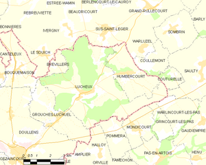
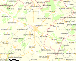
Bouquemaison (Bouquemaison)

- commune in Somme, France
- Country:

- Postal Code: 80600
- Coordinates: 50° 12' 41" N, 2° 20' 14" E


- GPS tracks (wikiloc): [Link]
- Area: 7.15 sq km
- Population: 520
- Wikipedia en: wiki(en)
- Wikipedia: wiki(fr)
- Wikidata storage: Wikidata: Q540226
- Wikipedia Commons Category: [Link]
- Freebase ID: [/m/03mbc15]
- GeoNames ID: Alt: [6444288]
- SIREN number: [218001188]
- BnF ID: [15276606t]
- VIAF ID: Alt: [244161827]
- INSEE municipality code: 80122
Shares border with regions:


Grouches-Luchuel
- commune in Somme, France
- Country:
- Postal Code: 80600
- Coordinates: 50° 10' 54" N, 2° 22' 56" E
- GPS tracks (wikiloc): [Link]
- Area: 9.02 sq km
- Population: 604

Lucheux
- commune in Somme, France
- Country:
- Postal Code: 80600
- Coordinates: 50° 11' 48" N, 2° 24' 37" E
- GPS tracks (wikiloc): [Link]
- Area: 27.65 sq km
- Population: 545


Canteleux
- commune in Pas-de-Calais, France
- Country:
- Postal Code: 62270
- Coordinates: 50° 12' 55" N, 2° 18' 27" E
- GPS tracks (wikiloc): [Link]
- Area: 3.4 sq km
- Population: 16


Neuvillette
- commune in Somme, France
- Country:
- Postal Code: 80600
- Coordinates: 50° 12' 29" N, 2° 19' 9" E
- GPS tracks (wikiloc): [Link]
- Area: 3.13 sq km
- Population: 218
Doullens
- commune in Somme, France
- Country:
- Postal Code: 80600
- Coordinates: 50° 9' 24" N, 2° 20' 25" E
- GPS tracks (wikiloc): [Link]
- Area: 33.4 sq km
- Population: 6321
- Web site: [Link]


Le Souich
- commune in Pas-de-Calais, France
- Country:
- Postal Code: 62810
- Coordinates: 50° 13' 22" N, 2° 22' 1" E
- GPS tracks (wikiloc): [Link]
- Area: 5.11 sq km
- Population: 156


Bonnières
- commune in Pas-de-Calais, France
- Country:
- Postal Code: 62270
- Coordinates: 50° 14' 39" N, 2° 15' 37" E
- GPS tracks (wikiloc): [Link]
- Area: 27.16 sq km
- Population: 656


Rebreuve-sur-Canche
- commune in Pas-de-Calais, France
- Country:
- Postal Code: 62270
- Coordinates: 50° 15' 53" N, 2° 20' 27" E
- GPS tracks (wikiloc): [Link]
- Area: 8.28 sq km
- Population: 203